10th May 2022
It was around 6am when I first opened my eyes on what was to be day 2 of my West Highland Way adventure. The light of day filtered in nicely through the outer fly sheet instantly giving me that lovely, warm, snuggly feeling which I always loved on all my wild camping adventures. The first thing I noticed was that there was no sound of rain and that was always a welcoming notion. If there is one aspect of camping that I could totally obliterate, it would be packing away a wet tent in the pouring rain. I mean, who likes it really? It makes your rucksack much heavier and can make the rest of your kit wet and muddy. It seemed that today however, I was off to a good start.
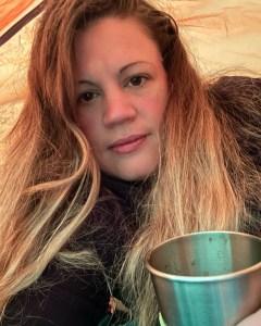
Despite sleeping the whole night through with no interruptions, I found waking up properly took a lot longer than normal. It had been such a peaceful spot in the forest with not a sound to be heard except for the occasional hoot of an owl and the gentle rustle of the trees, that the thought of leaving certainly didn’t come easy to me. Breakfast that morning consisted of a dehydrated meal by my favourite supplier Basecamp Foods and was a Granola with blueberries from their Expedition Foods selection. That and a double chocolate mocha with some breakfast biscuits to dunk went down a real treat.
Upon finishing, I realised that I felt somewhat revitalised with a new lease of searing energy and I couldn’t wait to pack up and be on the trail once more. Last night I had slept with my damp clothing in the sleeping bag, a little trick someone had once told me in passing when discussing camping in particularly wet weather. It had been suggested that if ever clothing was damp with a worry that it might not be dry by morning, that I should put it in the sleeping bag and allow the natural heat of my body to dry it. This was not something I had ever considered before and I did immediately wonder if it would actually achieve anything other than giving me a heck of a cold, however what did I have to lose? To my complete surprise, the tip paid off and by morning my hiking clothes were completely dry and ready to wear for another day.
Stepping out of the tent first off it was a beautiful sight in the forest and at 7am, it appeared I was the first camper awake. A short distance from where I was camped was a group of around 5 people. To say there were 5, they were so quiet the whole time they were there that I’d only noticed them by chance after I’d seen their torch lit tents on one of the occasions that I’d left mine. Now, in the light of the morning it appeared they were still sleeping. Despite full daylight, I was struck by how dark the forest still was in places, with only a few thin beams of light filtering through the thick firs. What an amazing place this was. The hike was still young but even at this stage, I knew this wild camp would remain one of my favourites for a long time to come.
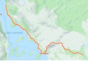
Overview: Day 2 walk route
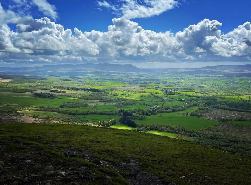
The aim of todays hike was to trek from my camping location in the Garadhban Forest to Ptarmigan Woods just shy of Rowardennan. The walk today would be longer than yesterday in which it was approximately 18 miles, this largely due to the long section of camping management zone along Loch Lomond.
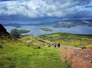
Today’s route would take me past the remaining parts of the Garadhban Forest and over open pasture land towards Conic Hill. Upon climbing the path as it follows the West Highland Way, I hoped to finally witness for myself the spectacular scenes of the Loch and surrounding mountains from a high vantage point. In order to obtain the best viewing opportunity and really make my trip worthwhile, I had decided to summit Conic Hill, something that not every hiker of the way actually does. The West Highland Way although it climbs high up Conic Hill, it does not lead all the way up to the summit but rather skirts around it before dipping back down the opposite side towards Balmaha. Venturing to the summit, I knew would add elevation and distance onto my walk but felt that having travelled so far to be part of the way and Conic being one of the most iconic places, it would defeat the object not to. I intended to take a rest stop here and really get as much out of the location as possible.
From then on, I would head downwards into Balmaha where I intended to break for lunch before beginning the long gruelling trek along the shores of Loch Lomond. This stretch along the Loch is very long and I would not be completing it all in one day. However, my aim was to wild camp again tonight and therefore I would need to reach Ptarmigan Woodland in order to do this. The West Highland Way passes through various places along the banks of Loch Lomond from pretty sandy beaches at Balmaha right through to large oak forests at Cashel, Milarrochy and Sallochy. Upon reaching Rowardennan, it is the starting point for when people hope to climb Ben Lomond, one of many Munro’s in Scotland. So overall, there was a lot to sight see from this day onwards and upon completing my day, hoped to find a quiet pitch in the woods just outside the camping management zone 2 miles outside Rowardennan. Unfortunately, on this occasion there had to be a slight change of plan regarding my camping location and a complete rethink of what worked best in my favour which I will explain later in this post.
Loch Lomond camping and fire lighting management bylaw
During the period 1st of March to the 30th of September there are camping and fire lighting bylaws in place along the stretch of Loch Lomond between Conic Hill and Ptarmigan Lodge. No camping or fires are allowed at any stage within this section without a permit. There are camp sites which can be pre booked for a charge but no wild camping under any circumstance. The area is closely monitored by rangers of the Loch Lomond and the Trossachs National Park and fines of up to £5000 can be issued if caught.
The bylaws were introduced in an attempt to prevent the landscape from being damaged by erosion and over population as the area is so frequently visited during the Spring and Summer months. Litter and damage caused by campers and fires was slowly taking its toll on the shoreline, woodland and forestry within the Trossachs. Wild camping is not affected in the months from October through to the end of February respectively.
Leave No Trace
After a quick pack up, this was my final photograph of my camping location within the Garadhban Forest. I left the site exactly as I found it and took all rubbish I had accumulated away with me. As I always say ‘leave nothing but footprints, take nothing but memories’.

As 8am approached I glanced out of the forest towards the West Highland Way and noticed that other hikers were now starting to pass. As sad as I was to leave my cosy spot, I realised that my time here was over. Conic Hill was whispering on the wind and it was now the start of day 2.
Garadhban Forest to Conic Hill
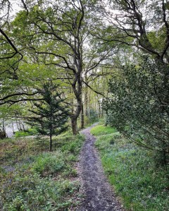
Hitting the trail once more, I began following the pathway towards the heart of Garadhban. As I walked I couldn’t help but marvel at just what a beautiful forest this was. On either side of the path grew tall evergreen pine trees which towered high above me. It reminded me very much of the long straight pathways I had seen so much in fairytales of winter magical forests and found myself wondering just what this location would actually look like in thick winter snow. I bet it would be every bit as breathtaking as I imagined.
After approximately 10 minutes of walking, I began to feel the familiar sensation of drizzle on my cheeks despite hoping for a better weather day. Battening down the hatches I pressed on regardless. As I walked, I was impressed by the number of good quality, potential wild camping pitches that I noticed on either side of the track. Some were even still occupied and it felt good being able to receive a friendly ‘good morning’ or a ‘hello’ from other West Highland Way hikers.

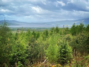
The track here is very easy going underfoot despite being long sections at times. Rounding a bend as I headed out of the densest parts of the forest, I began to catch my first glimpses of the mighty Loch Lomond over the pine trees on my left. What an amazing moment this was to finally see it! Despite the drizzle, the viewing was much better today than I had expected which lifted my spirits no end and I felt more and more energised at the thought that I was getting nearer.
It was here in this location as I ambled along that I was joined by an older Scottish gentleman who was also hiking the West Highland Way. I walked approximately 2.5 miles with him as we headed towards Conic Hill and enjoyed an interesting conversation regarding our own hiking excursions. He told me that he was on a holiday to this part of Scotland and was staying locally in a cabin with his wife who kindly dropped him off everyday at the spot he finished at the previous day. Although he wasn’t camping and had hiked sections of the way before, he had always wanted to complete the trail in full from start to finish and due to his age, felt he shouldn’t put it off any longer. He went on to tell me of other stunning locations he had visited in the highlands and of the Munro’s he had completed. Our final conversation was about how he had drank contaminated river water whilst out on one of his adventures and had paid the ultimate price for it. Despite leaving his company a short while later, it was lovely to break the day up with a chat. I never saw him again for the rest of the hike but I thought of him throughout my adventure and really hope he managed to complete the trail as he had planned.
The rain continued to fall intermittently as I pressed onwards along the track and rather than keep taking off my outer shell rainproof clothing, I had opted to keep them on. Despite feeling grateful of how effective they were, I was beginning to feel very hot and sweaty by this point. Walking in outer shell is not the most comfortable but I knew the second I removed them it would begin to rain again. The Scottish weather certainly does have a lot to answer for!

Presently, I reached a road and signpost which clearly showed a path split in the West Highland Way. Here, hikers get the option of taking the lower route into Balmaha and therefore missing out the iconic scenes of Conic Hill. The route leaves the footpath and heads down a road towards the left, whereas the route for Conic Hill continues forward. I chose the way forward as there had been no question in my mind about summiting Conic. I knew it was not going to be easy especially with a full rucksack but I knew in my heart it was doable and the views from high up would be completely worth my while.

Continuing onwards I approached a large metal deer gate which appeared to be the final gate before entering wide open pasture. This marked the end of the forest hiking at Garadhban and from now on, I would see more of the rugged mountain territory which the West Highland Way was famous for. It was here though that I realised I was now within the camping management zone mentioned earlier and there would be no opportunity to wild camp from now on until I reached Ptarmigan Woods.
The heathery section of forest close to the deer gate was clearly a popular wild camping spot and I fully appreciate the reason why people choose the area, however to my dismay, I spotted an alarming amount of litter, broken camping equipment which had been thrown into the trees and lots of used wet wipes, sanitary products and toilet roll behind bushes. It really was quite shocking to see especially in such large amounts. We as hikers carry a lot of kit in our heavy rucksacks and go to the trouble of lugging it long distances without giving it a second thought, yet so very often, it is too difficult to carry away rubbish which weighs next to nothing and is only the same as carrying it to the location in the first place. Leave no trace people, that’s the way it should always be. Our landscapes and wildlife are precious and even if that thought isn’t enough, for our own peace of mind we should try and think about the lasting damage and what others will think when they see it.
Leaving the high deer gate behind me, I began heading along the mud path towards open pasture. It was a strange feeling which came over me at this point as I thought about the beautiful forestry in which I had just enjoyed. I find it fascinating how hiking long distance trails can bring out the most vivid and powerful emotions in the blink of an eye without any warning and we can find ourselves reminiscing about things we might not have thought about in ages and probably wouldn’t in any other situation. As much as I was looking forward to Conic Hill, I was sad to leave the forest. It signified the end of a chapter in my West Highland Way adventure, one which wouldn’t come again on this journey. I found myself wishing that I could take it home so it would always be a part me and if I felt like this now, how would I feel the further along the trail I ventured?
By now the footpath consisted of mud and tiny stones with open land around me made up of nothing but moorland grasses, the odd tree and the rolling hills which broke up the landscape. Terrain here was easy enough and to my right I could see the mass of Conic Hill looming up. As I glanced in the direction of the pathway, I could see it drop down into a ditch of trees before heading up the hillside and as I looked carefully, I spotted the tiny coloured dots forming a single thin line curling and winding right to the top. It was the colourful coats of the hikers before me as they picked their way up the hill on the narrow path and it certainly showed how crowded this section of the way was today.
I remember feeling relieved that the viewing today was good. The weather had somewhat improved with a warm feel to the air and the rain had temporarily stopped. There was even specks of blue sky breaking through the clouds every now and again. If there ever was a perfect time for clear viewing it was now and I can only thank the Gods of hiking that day.
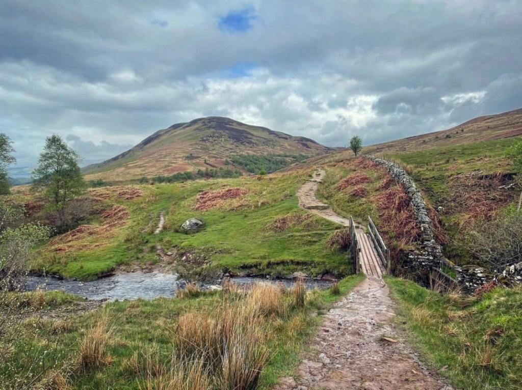
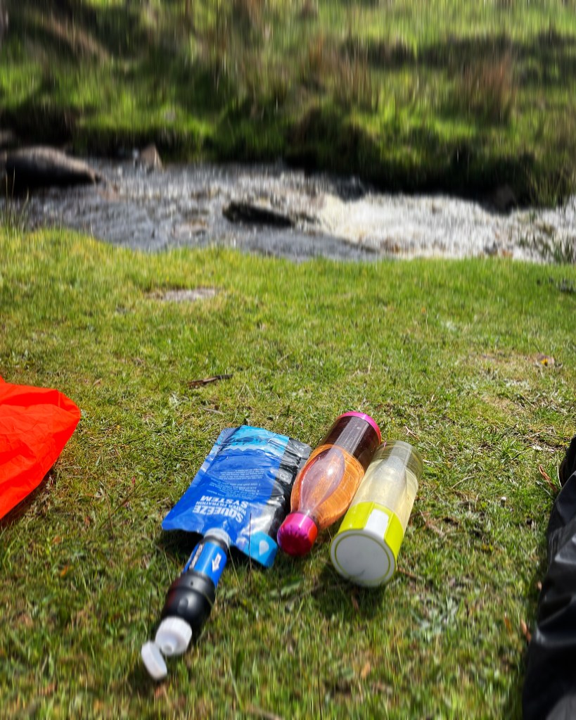
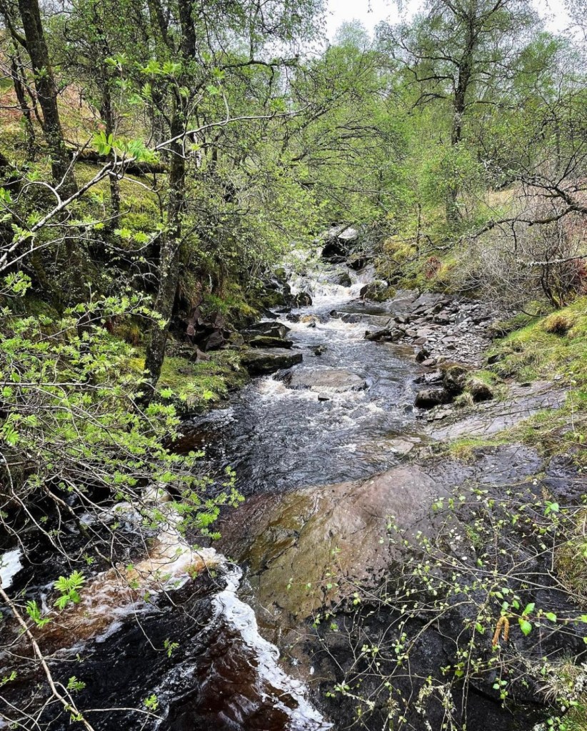
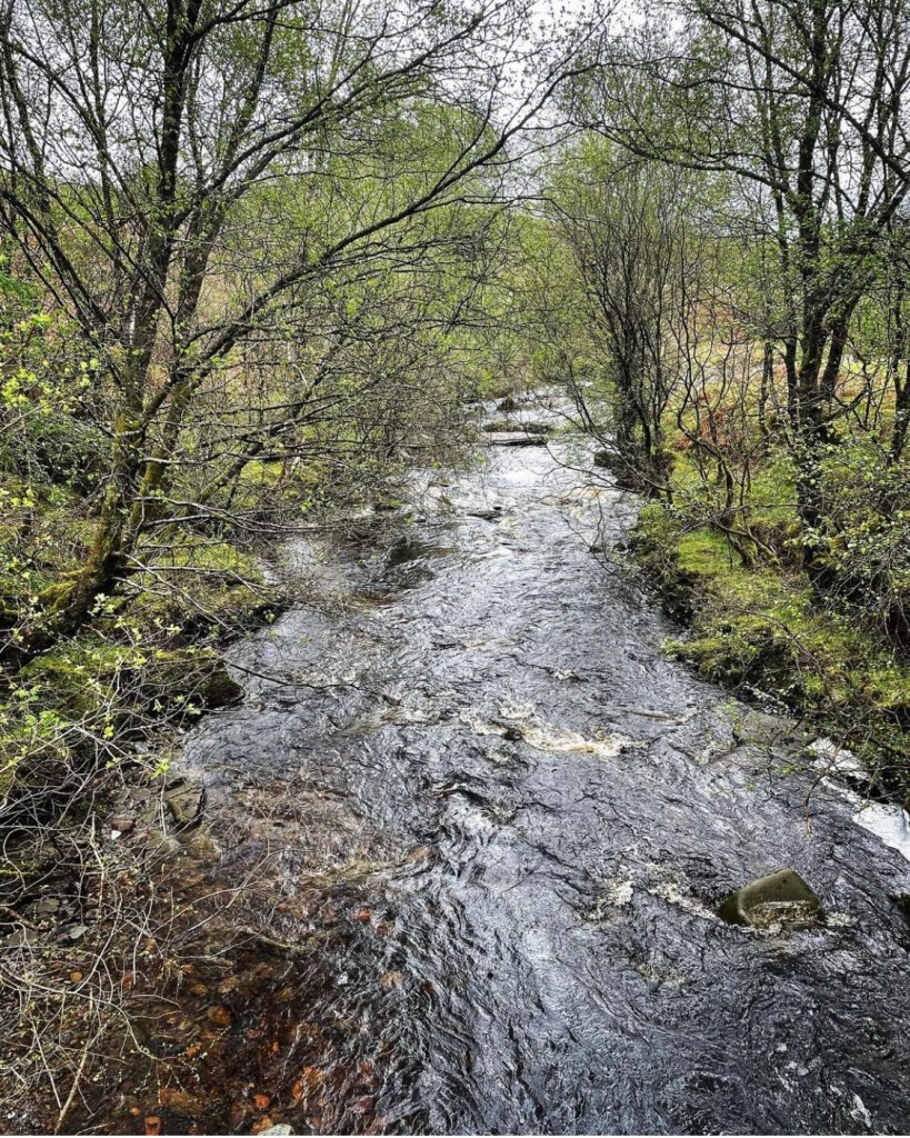
However, it was here in this moment that I realised I was running low on water and needed to top up before the climb up Conic. The pretty footbridge running over the river seemed to appear like magic and I sat down on the grassy embankment in the sun for my first real rest stop of the morning. It was a lovely place to rest and I spent a good 15 minutes here filling my water bottles and filtering it before continuing onwards. Due to the lack of a water source in the location of my camping spot the previous day, it had been a worry as the morning had gone on about where I would next find some. Yet this stream was probably the best I could’ve found as the water was fast flowing and clean.
Beyond the bridge, the pathway begins to dip down a hillside towards the base of Conic Hill and crossing the Burn of Mar bridge I noticed a mass of people resting here before the imposing climb. Pressing onwards, I began to slowly climb the steep, rocky steps which marked the start of the climb.
Conic Hill to Balmaha
The climb up Conic Hill is definitely a hard one with a heavy rucksack and one which shouldn’t be underestimated. Terrain during the hike up begins very steep from the outset with rocky, steep, steps cut into the hillside before becoming rocky underfoot which at times requires scrambling on large, loose and unsteady stones. As the route climbs higher, the views begin to really open up and the fantastic landscape and open moorland can be viewed all around in its splendour.

Colours to the landscape here in early May consisted of a range of greens, creams, russet and browns and were made up of a combination of long moorland plants and grasses.
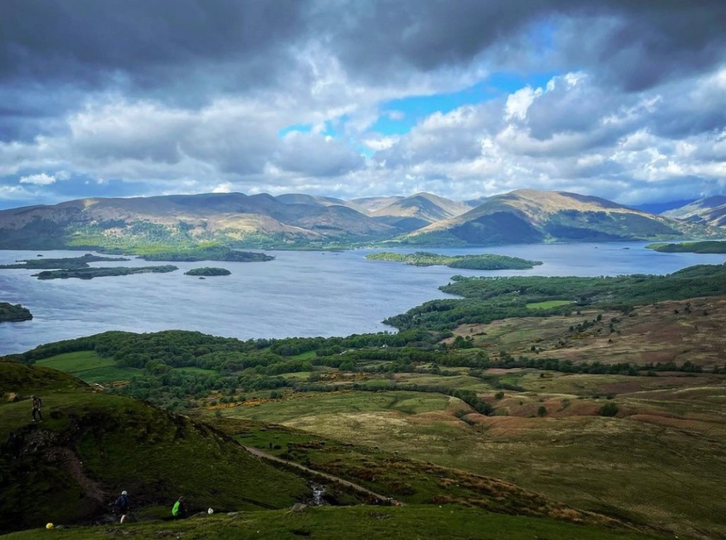
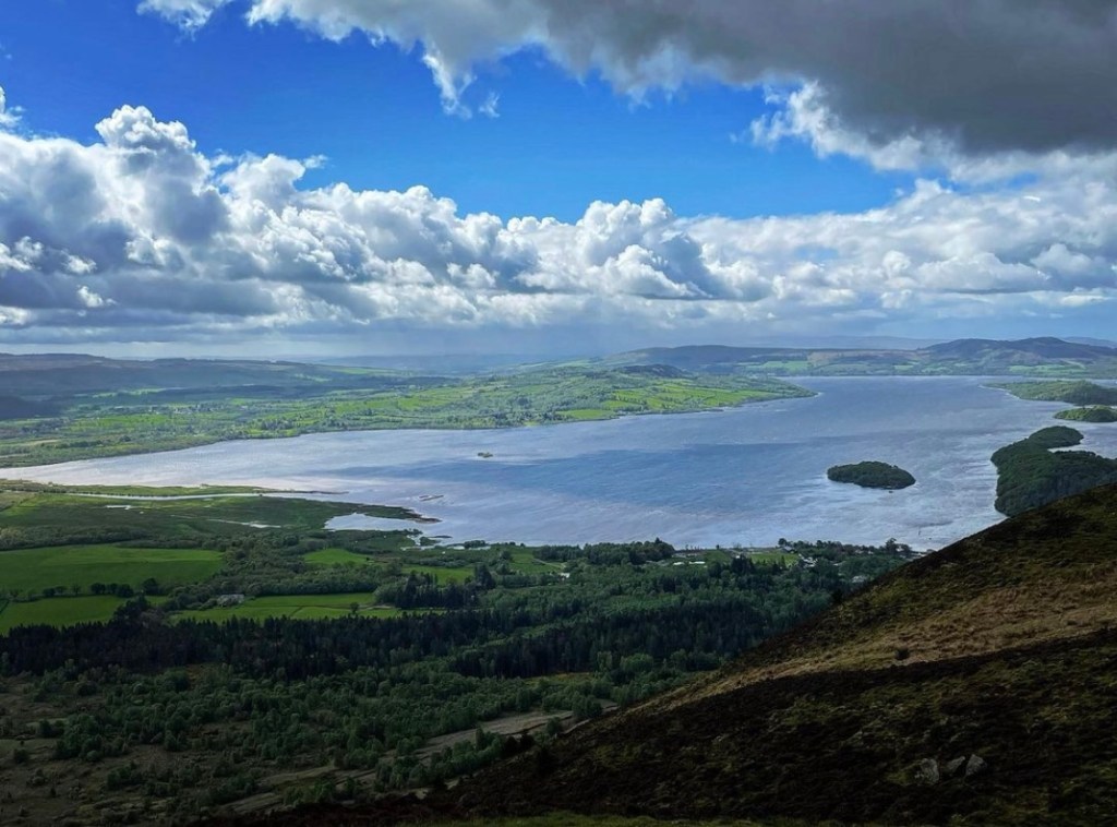
As you climb higher still and approach the section of path which heads past the summit, you will be gifted to amazing views of Loch Lomond and the surrounding hills and mountains. The photo below is one I took on my approach towards the highest section of path on Conic Hill. The footpath here is generally easier underfoot too and makes a nice treat after such a strenuous climb.

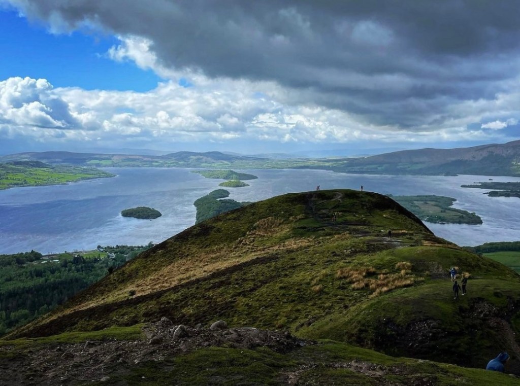
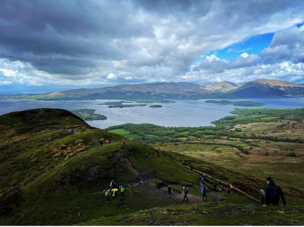
To venture to the summit of Conic Hill it means leaving the West Highland Way main path and taking the turn-off on the left which heads steeply uphill. After climbing a short distance, the pathway becomes a scramble over jagged rocks before reaching a flat section of hill in between what appears to be two summits. It turns out that the hill on the right is a sub summit known as ‘Little Conic’ which has spectacular views over Balmaha and Loch Lomond. It stands at 358 meters (1,175 feet), is somewhat easier to climb and is relatively level once onto it with a short walk across to the summit. The main summit of Conic however is a little trickier to reach and involves a steep scramble up the hillside. The wind by this time was incredibly strong as I reached this point and decided upon leaving my rucksack on the grass in between the two summits.
The scramble up was not easy and full concentration was required. However once there, I knew in an instant that my efforts were not in vain when I saw the amazing panoramic scenes which surrounded me. As I stood there being buffeted by the wind and taking in the stunning views, I remember thanking my lucky stars that my day of visiting was today and not yesterday. With the amount of rain and mist, the views would’ve been none existent and I would’ve missed this awesome opportunity. I spent a good 45 minutes here totally in awe and hardly able to catch my breath before heading back down towards the main path of the West Highland Way.

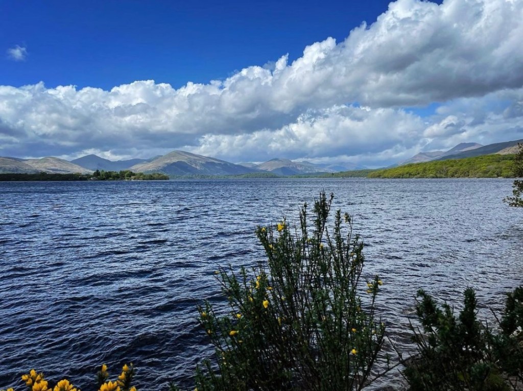
Check out the views from here though! It was definitely a magical moment standing right here, right now. The sight of the mighty Loch Lomond before me, complete with its tiny islands dotted about on the water and then looking further afield and seeing the most southernly Munro Ben Lomond and the rocky hills of the Arrochar Alps.
A part of me has always wondered why so many people choose not to climb Conic Hill. The route over Conic is the true West Highland Way and in my opinion, one of the best parts of the whole hike. I make an exception of course to those people who, for whatever reason, cannot climb or have health problems but I struggle to comprehend how anyone of fit and able health who enjoys hiking and spectacular scenery, can choose deliberately to boycott such an experience. I actually know of one long distance hiker who said that he had seen it once and so didn’t need to see it again. Me personally, I could never get bored of the sights at Conic Hill and it will always remain a must see on any future West Highland Way hike I partake in.
Below is a small gallery of photographs taken from the main summit of Conic Hill in an attempt to capture the panoramic views all around.

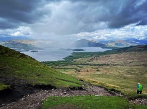
In the photo below, I managed to capture a large rain cloud which was drifting towards me with every second that passed. There was no escaping it. I was going to get drenched and quickly began the knee shattering decent down into Balmaha.
If climbing Conic Hill is one obstacle, then it’s descent down into Balmaha is well and truly another. From leaving the summit there is still a considerable distance left to cover and this takes time and careful navigation. The path underfoot is very rocky and uneven and this becomes more obvious the further down you go. There is a large section of the way where intermittently, steps have been created in the rocky path in an attempt to make the way easier to climb or descend. However, over time and with the large crowds of hikers who frequent the way, the pathway and steps have fallen victim to substantial levels of erosion.
WARNING TRIP HAZARD: Wooden slats were originally placed as mud guards in the steps and at the time I visited, the mud behind them which had once been flush to the wood had completely worn away. This left the slats sticking up which made them a treacherous trip hazard. Mindfulness and extreme care is definitely a must here! As can be seen in the next photograph, this section is not the easiest and was made all the more nerve racking by the arrival of torrential rain which made the way ahead very slippery indeed.

However the hard work was greatly rewarded by this small section of beautiful forestry which the trail leads through before reaching the car park at the Loch Lomond and Trossachs Visitor Centre in Balmaha. I was certainly grateful to get out of the driving rain by this stage and the high fir trees gave great cover.

Upon arrival at Balmaha, the trail crosses a large car park at the Loch Lomond and the Trossachs Visitor Centre. I briefly called in here to check out what was on offer and found it to be very useful in that there are toilet facilities which can be accessed at a charge of 50p and lots of tourist information regarding the local area and walks around the vicinity.

Feeling hungry now I headed towards the Oak Tree Public House in the centre of Balmaha where I intended to take my lunch spot of the day. Settling down outside on one of the neat wooden tables and chairs I couldn’t help but notice what a stunning area this was. To my right was a pretty coffee shop which smelled divine and by the looks of the plates on the table to my right, their cakes looked to die for! Across the road was a pretty picnic spot with benches and would’ve made a beautiful place to sit in the now beaming sunshine. Just another example of the temperamental weather here in Scotland, it was hard to believe I had been caught in a storm only moments before, if it wasn’t for my soaking down jacket on the back of the chair.


Balmaha to Sallochy Bay
It was now 2pm and I had ended up staying at the cafe a little longer than planned that day in Balmaha. Now that I had eaten, I have to admit that I was beginning to feel sleepy as I sat in the warm sunshine. Sleep was not an option though as I still had quite some miles left to cover before I reached my camping spot. The rest stop for lunch had only meant to be brief, no more than 30 minutes at the most but the food had been delicious, the company good and the location so attractive that I had forgotten about the time. Glancing at my phone though, I knew that my day was delayed considerably and I quickly grabbed my rucksack and began heading along the road towards the water’s edge.
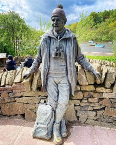
Just before meeting up with the shoreline at a small harbour, I was fascinated to discover the Tom Weir Statue which was erected to mark what would’ve been Tom’s 100th birthday on the 28th of December 2014.
Tom Weir was a Scottish climber, author, poet, TV presenter and lover of the great outdoors. He wrote articles for Scots magazine for 50 years and ran his own TV series Weir’s Way which ran from the mid 1970s until 1987. The series saw him travel to Scotland’s most beautiful locations and gave viewers a real insight into the vast and amazing scenery which can be enjoyed within them.
It is also here around the location of the statue that you will find the next blue water tap similar to the one located at the obelisk at the start of the West Highland Way. I used this opportunity to top of my bottles before swiftly heading onwards.

Following Rowardennan Road, the main road through Balmaha, this lead me along the edge of the Loch before turning sharply off to the right. The West Highland Way trail however continues forward along a narrow lane for a short distance.
When strictly following the trail as it states in the Official West Highland Way Trail Guide, hikers will notice around this location, that they are guided to follow the thistle motif as it directs people off this lane along a path on the right. I chose not to do this and to continue following the lane for an alternative route along the shore of Loch Lomond. I have been asked a number of times why I made the choice to deviate off the main trail as the route I chose was not in any way less in distance, it was purely from a scenery point of view.
A few weeks before beginning my adventure, I had received some useful pointers regarding the way from a friend who has hiked the route multiple times. He walked both routes and described them clearly stating that the path which the guide directs people along leads steeply uphill and through trees with a promise of two viewpoints which supposedly give spectacular views of the Loch. However, when he walked that section, the views could not really be seen all that well despite the high climb. He advised me to remain following the road and to cross the metal footbridge close to the waters edge before sticking to the narrow mud path. This only lasts for approximately 2 kilometres at the most before meeting back up with the original trail but the views along the entire length of the Loch can be seen clearly here and therefore, I felt this gave me a better experience overall.
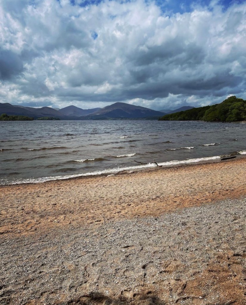
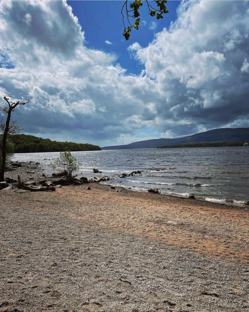
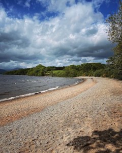
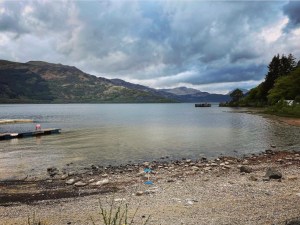
Walking along the sandy path close to the waters edge, I eventually came across Balmaha Beach, a number of sandy coves which are dotted along the shoreline. The sun kept making an appearance too in between the scattered rain showers which had dominated most of today. Taking a rest stop once more, I sat down on the beautiful pale sand and took in my surroundings. I couldn’t have been gifted to such a beautiful place if I had tried.

Balmaha Beach is a proper sand and shale beach with views across the loch towards the tree lined shores with the tall rolling mountains that still contained the last snows of winter. It felt strange sitting there in the heat of the afternoon sun yet seeing snow on the hill tops. I still had on my waterproof outer shell and was very sticky indeed, yet I knew better than to take it off.
It was hard to keep on walking without stopping to admire what was around me and I think a lot of time went around this location. Hanging out here on the comfort of the beach was like a little slice of heaven in my own mind and in an instant, all my worries seemed to melt away. Before long, I had spent an hour here and I could sense the afternoon light beginning to change. I knew that time was getting on and I was only 2 thirds of my days route along, yet I felt so in the moment that it was hard to pull myself away.
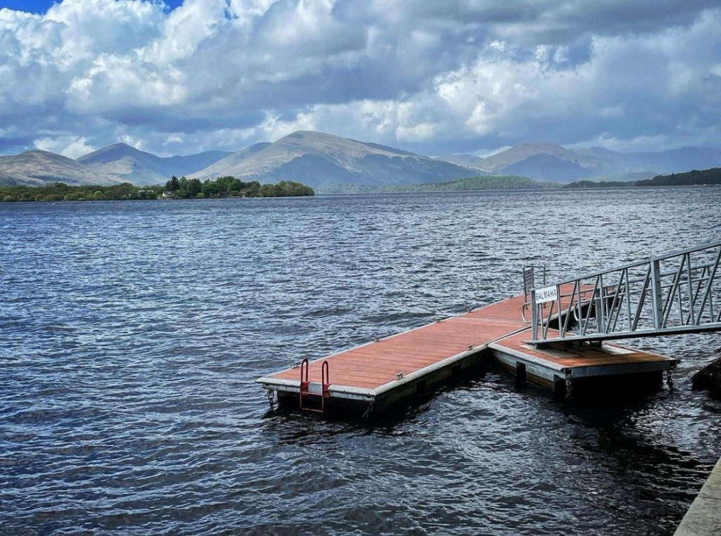
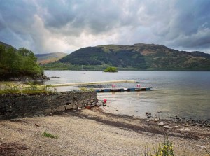
The next section of trail involves hiking along the beach and shoreline for quite some distance before eventually arriving at Milarrochy Bay. Here, there is a car park at the waterfront, benches, public toilets and various information boards. There is also a water tap with clean water although I did not utilise it on that occasion.
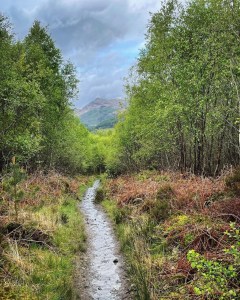
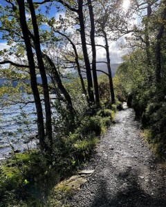
Upon leaving Milarrochy Bay, the trail heads inland briefly as it rounds a great corner in the Loch. A short section of road walking here is required before heading uphill into woodland. It is a very scenic piece of woodland with its long windy path which rises and falls as it follows the contours of Loch Lomond. At one point, I rounded a sharp bend onto a flat and straight running path and right in the centre of my view with the trees framing it, was the spectacular and popular Scottish Munro Ben Lomond.
Meeting up with Rowardennan Road at the end of the woodland stretch I realised that I was at the village of Cashel where there is a campsite if needed. After a brief rest stop on a stone bench, I continued along the never ending trail.

The section here involves a lot of road walking for quite some distance as it runs beside the Loch. At times, the trail alternates between road and beach before finally turning off to the left into more woodland. This forest is more dense than the last with thick trees growing close together. In the fading light, it made the day seem much later and I was beginning to feel nervous that I would not reach my camping spot before nightfall. It was also an extremely long stretch of path which really made me question if it was ever going to end at all. By now I was feeling the strain of the days walking, my backpack laying heavier than ever, it’s straps cutting into my shoulders with every rise and dip, thighs on fire and just feeling plain washed out. I began to pray right there and then that the end of today was near.

Sallochy Bay to Rowardennan
As I approached Sallochy Bay Campsite at approximately 6.30pm, I remember gazing longingly at the tents pitched up on the shoreline and wished that I had booked one myself. I was absolutely done in by this stage and I still wasn’t near my finish line for today. I thought back to when I had started planning this hike and had read all the comments written by fellow West Highland Way hikers who had all clearly stated that day 3 was by far the hardest day. If today was this hard, just what was tomorrow really going to be like?
Taking a seat at one of the wooden benches at the campsite, I hastily boiled some water for a coffee whilst in desperate need of a caffeine boost but no sooner had I made it than the heavens opened and I was once again soaked through. Taking shelter under a large Oak tree seemed my only comfort right then and it certainly was a better shelter than being stood out completely in the rain.
Leaving Sallochy, the trail continues on and heads slightly inland up some steep wooden steps heading further into the woodland. From there, it is a case of following a single mud path as it winds and curves. Terrain is not the easiest for so late in the day as it involves climbing with some rocky ascents and descents. However the photographs below are what I enjoyed upon glancing over my shoulder as I embraced the steps. As can be seen, the daylight was fast fading.
It was here in this moment that I realised once again that I was probably the only person still walking the trail at this stage. It really was a strange feeling to be surrounded by hikers one minute and then suddenly not the next and I began to experience that lonely feeling that I had felt towards the end of day one when I was in a similar situation.
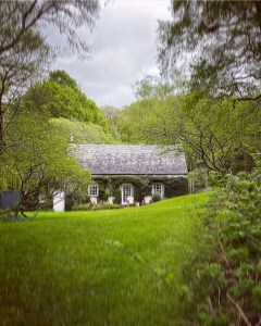
Heading further along the path I came to a section where it twists and turns through more woodland before noticing this pretty cottage set back from the path. The Mill of Ross Cottage. Despite feeling extremely tired and deflated, seeing this cottage was like a breath of fresh air. Just what I needed at this stage of my journey.
However my elation didn’t last long in the fast fading light of day. It was now approaching 7pm and any hope of reaching Ptarmigan Woods before darkness was almost none existent. As I pressed onwards along the many winds, dips and twists in the rocky steps and pathways, the last of my energy was finally zapped out of me and limping into Rowardennan, I headed straight for the youth hostel. On the way, I passed the Clansman Public House where there is a convenient water tap just outside the front door. Here I met the couple who I had met the previous day whist walking at Dungoyne and ate with at the Beech Tree Inn. It was so lovely to see them once again yet my exhaustion must have clearly been visible. So much so that they directed me to the youth hostel where they had booked their own room.
Passing the visitor centre at Rowardennan was a sought after milestone as it meant I hadn’t far to walk before reaching the hostel. In the visitor centre, it was handy to know that there are public toilets which were open despite the centre being closed. Sadly I missed the Rowardennan War Memorial which is located just beyond the visitor centre and close to the edge of Loch Lomond. It is however a well known landmark of the West Highland Way and one I hope to visit when on my next adventure.
Rowardennan Youth Hostel

The Rowardennan Youth Hostel is located on the outskirts of Rowardennan at the edge of Loch Lomond and in very close proximity to the West Highland Way trail. It is very popular with backpackers of the trail and for people hiking in the local area. As well as rooms for rent in the actual hostel, there are a number of camping pitches in a designated area at the loch side which can either be pre booked or rented on a first come first served basis. When booking camping pitches, guests can still use all the facilities within the hostel. There are toilets and showers, a communal lounge with sofas and tables with chairs, a full kitchen with all utensils, dining area, a shop with a range of basic toiletries and snacks and clean towels. Camping pitches are booked by making a donation of £10 to the hostel which was the price I paid in May 2022.
The photograph above is the only photograph that I took at the actual hostel due to feeling extremely fatigued. It was a view over the gardens towards Loch Lomond taken from right outside the hostel doorway. In hindsight, I wish I had made more of an effort to at least get one image of the hostel but at the time it was not my number one priority. For that I can only apologise.
Camping Spot
The camping area at Rowardennan Youth Hostel is a beautiful spot on a wooded bank at the side of Loch Lomond and close to the house. At the time I visited, there were only 4 tents pitched up so I had a choice of around maybe 5 other pitches which were available. Many of them had been used so much that the grass had long since rubbed away leaving nothing but bare soil and after the heavy rainfall over the last few days, this made for very muddy camping indeed. However, I managed to find a small pitch on lots of wild grass and other vegetation a short distance from the rest of the campers. It was actually a beautiful place to camp on a high section of bank above Loch Lomond and had great views across the water and right back down the Loch.
The only critique that I have about the pitch was that it was very fiddly to get tent pegs in due to how hard and stoney the soil was and took quite a few attempts before the tent felt secure. Unlike my cosy pitch last night in the Garadhban Forest which was surrounded by thick pine trees and kept me relatively warm and well sheltered, this pitch was more open to the elements including the cold mist which breezed gently across the water.
After getting set up for the night, I headed towards the house for a hot shower which felt like absolute bliss! The shower, I was fortunate to get a day early as my first shower of the hike was supposed to be at Beinglas Farm where I had booked a pitch on night 3. It was a good job really as by the end of today, my clothes and me absolutely stank! I felt hot, sticky and very uncomfortable so a hot shower did me the world of good. It felt grand to be sat in the tent afterwards all clean and warm in my fleece eating a dehydrated meal of chicken hotpot by Basecamp Foods and drinking hot chocolate. Hiking to me is all well and good but the best times come later when all the hard work is over and done for the day and I can relax eating warm food, all tucked up warm and cosy.
It was a strange feeling that came over me as I let myself out of the tent for the last time that night. I was absolutely shattered and worn out beyond belief but not quite enough to stop me wandering out and down to the waters edge to take a look at the misty Loch before me. Behind me was the beautiful Rowardennan Youth Hostel with its pretty lights and well lit windows and as I stood and watched, I could see life continuing on through the glass, people laughing as they chatted in the sitting room, couples sat at tables talking, friends sat snuggled close on the sofas, others sat drinking a beer or two, no doubt talking about their day of hiking the way. I had been invited by the couple I had seen once again at the Clansman Pub to join them in the lounge on their return. Although I had considered it, I realised pretty quickly that I was just too tired. It had been a tough day and my body needed sleep. As I stood there I realised that time for me had stopped whilst everyone else’s carried on. That really is the best way I can describe it.
Climbing into my sleeping bag that night I snuggled down into its folds. What a day it had been. Conic Hill and Balmaha Beach had been my highlights of todays walk but they had also been my downfall. I had spent so long there that I had run out of time and knew I had to be more aware of time on the days yet to come. The last thing I remember of that night was reading a comment on my social media from a fellow hiker of the way who advised that I break tomorrow up if I found today hard. I was fast asleep before I could even give it a second thought….

Hike Summary
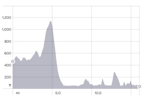
Distance walked: 16.16 miles
Elevation gain: 1,949 feet
To summarise day 2, I will start by saying that I thought today was a very long, drawn out and tiring day. It turned out to be just slightly over 16 miles that I hiked beginning as early as 8am right the way through to 8.30pm that evening. I have heard people say that it shouldn’t have taken me that long to do and that I better prepare myself for day 3 as it is considerably harder. Yet I feel that I knew already where I went wrong that day. Stopping so much to sightsee in a particular location such as Conic Hill and Balmaha definitely held me back but when looking at the situation properly, the more I feel that I got so much more out of the experience despite it meaning that I didn’t make Ptarmigan Woods before nightfall.
Although I didn’t arrive in time to my desired wild camping spot at Ptarmigan Lodge I was fortunate to have Rowardennan Youth Hostel to fall back on. I remember my sudden panic as I arrived at the door when I realised that there might not be any pitches available. The West Highland Way is a very popular trail and most camp sites get filled very quickly especially at the height of season. The relief that washed over me when the kind lady on reception reassured me that I could camp was indescribable and if I could remember her name I would give her a mention right now. Sadly I cannot and so can only call her ‘kind lady’. The added bonus of being able to grab a shower a day early really helped too as I had underestimated how tough the day would be and how hot and sticky I would feel. There really is nothing worse than stinking to high heaven and feeling uncomfortable at the end of such a tiring day. At least this way I was relieving this problem and starting out fresh the following day.
Conic Hill was one of my highlights of todays walk. In addition to that I chose to head onto the actual summit which is not part of the West Highland Way. This added distance and effort onto what I call an already strenuous walk. In saying that, I don’t regret a single thing. Conic Hill has some of the best panoramic views of the whole trail and I 100% recommend it!
My second highlight was the beaches at Balmaha and along the strip at Milarrochy Bay. At times when the sun shone through and I could clearly see the snow topped mountains on the backdrop across Loch Lomond I could almost imagine a landscape in Norway or Switzerland as opposed to Scotland. It’s at times like this when I curse myself for not having a better camera than the iPhone 12….
The long drawn out sections were at times challenging and really drained me of my energy as the day went on but I knew better than to keep stopping. What made the day tougher for me after careful analysis, was perhaps the fact that despite sleeping all night the previous night, the quality of my sleep really hadn’t been that great. My first night camping on the trail is always hit and miss due to being in a strange environment. It takes time for me to properly become accustomed to it. Secondly, I noticed that day 2 of all my long distance hikes tends to be a killer. The same happened on my Loch Ness 360 hike too the previous year in which day 2 turned out to be one of the hardest of the whole 80 mile trail. If anything, the descent from Conic Hill was by far the most challenging due to its steepness, uneven pathway and treacherous erosion on the steps.
Signposting along this section was excellent. Never once did I feel lost or not know the way to go. The same with shops, food outlets, pubs, sources of information and water taps. There were plenty of opportunities to top up water bottles if the need arose.
Finally, the main reason I feel I struggled mentally with day 2 is that I knew it was the day I had to get through the camping management zone which was in affect at the time I visited in May. Whereas usually if I was overtired, I may have just called it a day and searched for a safe camping area but here I couldn’t. The whole zone is managed by rangers of the Loch Lomond and the Trossachs National Park and there is a fine of up to £5000 if caught therefore, it was deemed too much of a risk. The youth hostel came at just the right time in my opinion.
Overall though despite its challenges, day 2 from the Garadhban Forest to Rowardennan is a stunning walk and maybe next time with a little better planning, I can make the trip less stressful and actually enjoy all aspects of it. Tomorrow on day 3, will see me tackle what is supposed to be the most difficult day of the West Highland Way and continues along the shore of Loch Lomond right the way from Rowardennan, through Inversnaid towards Ardleish, Doune and through to Beinglas Farm.
I would like to offer a heartfelt Thankyou to all the people I had the pleasure to meet on day 2 of the West Highland Way trail, in particular the older gentleman I walked with through Garadhban for a short distance and who shared his past hiking adventures with me.
All the people I shared the iconic views with from high up on Conic Hill as well as the many people I climbed down to Balmaha with in the torrential rain.
The lovely couple from Worksop, Shay Boyfield and her partner Rick who I had the pleasure of walking with for part of day 1 and who directed me to the safe haven of Rowardennan Youth Hostel.
The kind lady on reception at Rowardennan Youth Hostel who made me feel so welcome that day when I felt my worst. It’s small things like that which really make an adventure for me and to you all I will be eternally grateful.
Carl Johnson for your continued support and your extensive knowledge of walking the West Highland Way throughout the years. You kept my spirits up as darkness crept in at the end of day 2 and spurred me on in my desperate hour of need. Thankyou for that.
Finally to anyone who takes the time to read my blog. It means more to me than anyone can imagine. I hope this post has helped someone to plan their journey and given an insight into what is to be expected within this section. Once again Thankyou and hope to see you soon in part 3.
Happy Hiking
Lucy xx
Sources of information
Loch Lomond and the Trossachs (2022) Conic Hill. Accessed on 30/09/22. http://www.lochlomond-trossachs.org
Saunders, Paul (2022) Tom Weir Statue, Balmaha. Taken from See Loch Lomond. Accessed on 10/10/22 at http://www.seelochlomond.co.uk
The West Highland Way Trail Guide. Accessed 2022. Loch Lomond camping and fire lighting management bylaw http://www.westhighlandway.org
All photographs used in the creation of this blog post are my own and have been captured using an iPhone 12 camera device. They have been sourced and edited by myself Lucy Bailey from my Instagram account found at SoloExplorer23 using Instagram editor tool to enhance clarity and quality of the image. All distance and elevation images as tracked on Strava GPS are my own and were live recorded on the day in question.
