11th July 2020.
Overview
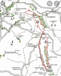
Starting at the lay-bys on Roach Road, the route took us up the designated public footpath through a small copse of pine forestry and up onto the top of the Roaches. From the top there is a path leading along the edge which covers the whole length, and offers stunning views of the Staffordshire side of the Peak District National Park. This is the route we took when doing this walk, however, we did take the additional trek to Lud’s Church which I will not include in this post. My reasoning for this is that Lud’s Church is a special location with amazing character and I felt this deserved a blog of its own which I will link to this page when published.
Both the walks combined are only 7.5 miles so a very short one indeed, however this walk was not about distance. For me it was about exploring and taking the time to check out the locations in detail. The walks might be short yet they are both bursting with action and surprises which take considerable time to explore fully. Therefore for the benefit of this blog, I will only focus on the Roaches here and will proceed afterwards to discuss Lud’s Church in finer detail at a later date. To return back to the starting point at the lay-bys when you reach Roach End, you can follow the Roach Road back along until you arrive at the starting point.
The Peak District National Park is one of my favourite places in the whole world and I feel truly blessed to have it so close to where I live. I meet many people whilst out on my travels and many are people who have travelled considerable distances to get there. It’s so easy to take for advantage the scenes of the Peak District that quite often we forget that it is unique in many ways. When comparing the Peak District to other National Parks in the UK, it becomes easy to see that each one offers a different feel and has its own character.
The Peak District is famous not only for its moorland and walking trails, but also for its rock formations, stunning edges and crags. Many of which cannot be found anywhere else in the UK. I have walked in a wide variety of locations in the Peak District now but at that time, I had tended to stick within the Edale and Derbyshire region. Realising that I needed a change in location and that there was so much more to explore, I made the decision to venture further to the opposite side to check out the Staffordshire Peaks and what it had to offer.
Starting at the lay-by (grid reference SK 00418 62114), we passed through the wooden gate and began the walk up the sandy, rocky path towards Hen Cloud. It was a beautiful, warm day that day in July with just a few clouds in the sky and it felt glorious to be out! The weather in recent weeks hadn’t been great and whenever the opportunity had arisen to go walking, it had literally bucketed it down with rain. Just my luck. Today however we had hit lucky and so had grabbed our walking gear and equipment and set out.
The path keeps on heading upwards towards Hen Cloud before approaching a fork which gives walkers the option of continuing up to the Cloud or heading off to the Roaches. On this day we decided to give Hen Cloud a miss and head straight to the Roaches, although I have heard that the views are spectacular up Hen Cloud and so have decided to definitely make the effort to check it out on my next visit, hopefully later in 2021.
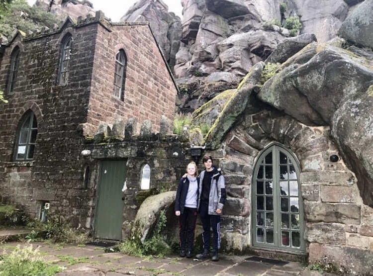
After taking the left hand fork in the path, we headed along as it began to climb higher. The path crosses over a stile and through a wooden gate before heading into a small copse of trees. At this stage we saw a building before us made of stone and so we ventured across to check it out. The building looked derelict as if it hadn’t been lived in for a while and appeared to be built into the cliff face itself. It was a very interesting find and I was immediately curious about it. There were some wooden benches outside it with a handful of walkers sat at them. We didn’t stay here long, eager to get up onto the gritstone ridge high up, but we did stop for a photograph. The house did have a very welcoming feel to it despite it standing empty and I was interested as to who had lived here previously.
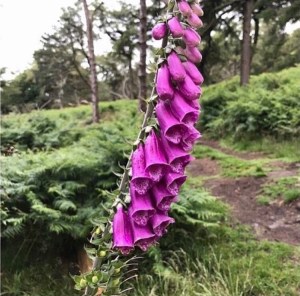
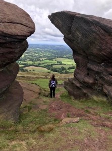
After leaving Rockhall Cottage, we began following the path up towards the Roaches which climbs rather steeply now through the wooded area of firs and evergreens. If you look towards your right at this stage you will see that you are at the foot of a steep crag of gritstone with sheer cliff edges and huge boulders. This location is very popular with rock climbers and there were already a good number of people already there with their climbing ropes. Further on down the path there are stunning scenes to be had of the rock formations and wild plants in this area. I had a good feeling already about this walk, the kind of feeling you get early on when you first set out and you get that spark from seeing what’s around you… and in that instant, you just know you made the right choice.
As the path climbs higher towards the crags, it becomes quite steep and involves climbing up and over rocks to get to the top. We followed the path up some rocky steps before climbing up and out onto the crag top to continue along the pathway along the top of the Roaches.
The Roaches
The Roaches is a superb rocky ridge of gritstone located in Leek, Staffordshire and the Peak District. It is just 8 miles outside of Buxton and is a very popular walking and climbing spot. The ridge is said to be approximately 2 miles in length starting from the accent up from Roach Road right over to Roach End. The highest point at The Roaches Trig Point is 505m (1,657ft) in height.
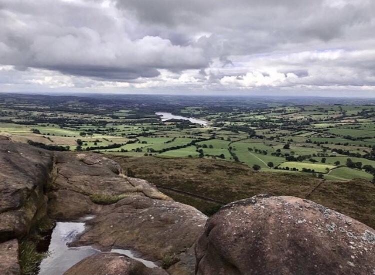
When walking along the top of the Roaches, there are spectacular panoramic views which span a considerable distance and include most of Cheshire, Snowdon in Wales and Winter Hill in Lancashire. The views from the Roaches can be enjoyed almost immediately and I couldn’t help but marvel at what I saw. As I looked out across the fields and countryside, I could see right across to Tittesworth Reservoir which is a local nature reserve and beauty spot to the area.
It was reported that in the 1930s, 5 Australian Wallabies were released on the Roaches and the colony survived into the 21st century, however, there have been no further sightings in recent years and they are now believed to be extinct.
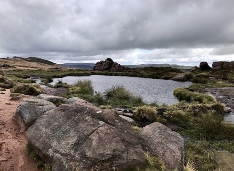
As we continued along the path we came to a large stretch of water which we later found was given the name ‘Doxey Pool’. I sat here for a while and had refreshments as I took in the surroundings, feeling at once a sense of calm and tranquility. This area of the Roaches is very beautiful and probably my favourite part of the crag top walk. It was rather like a large rock pool than a pond and it almost seemed like it didn’t belong up on the top of a crag like it was. It was not something I was expecting to find but that in my view is what I love about the Peak District, all is not as it seems… The quirks are priceless, the surprises endless and hopefully, they will be here to be enjoyed for many years to come.

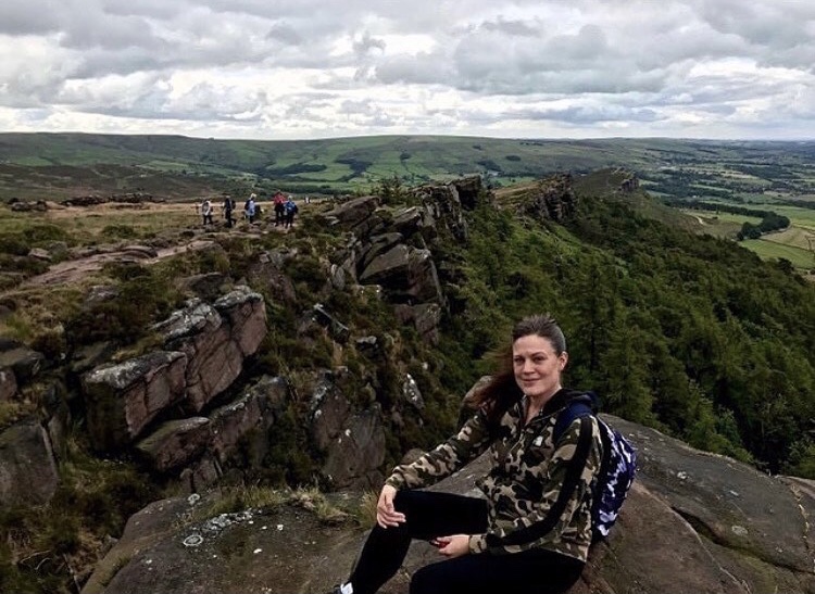
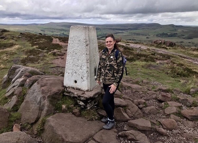
Continuing up the path along the Roaches top we eventually reached a short incline and headed up to the summit which is marked by a trig point. The trig point stands at 505 metres above sea level. From this location, it is possible to see right down the far end of the Roaches towards Roach End and across towards the woodlands which hosts Lud’s Church. The views all around are spectacular from here and I spent time just admiring the scenery.
Accessibility
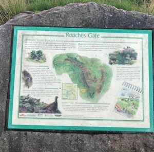
I arrived at the Roaches Gate by car after a friend kindly offered to drop me off there but the route can be easily missed if people are not familiar with the area. When following the A53 road from Leek, Staffordshire towards Buxton, people should take the turnoff for Upper Hulme which is signposted. It is located just shortly past the Three Horseshoes Hotel and after following this road a short distance, the lay-bys can easily be seen at the side of the road. They are free parking spaces and are very close to the start of the walk, however, they fill up very quickly! There is a pay car park further along the road and down in Upper Hulme village but it is a considerable walk to get to the start from there. It is important that people do not park outside the lay-bys as it is a favourite spot for getting fined. To say it is a secluded spot, the traffic wardens seem to have a field day in this location! I spotted tickets on a number of cars on our return to the starting point later in the day.
Once parked up it is a straightforward walk along the main path up onto the Roaches and there are a number of routes to choose from further up the path. There is the option of heading up to Hen Cloud should people wish to lengthen their walk and there are a number of paths which just focus on the area around the forestry and crag bottom. The actual paths up to the Roaches top are easy to follow, however do involve some climbing and does take a considerable amount of effort. Unfortunately, this route up the Roaches is not recommended for pushchairs or wheelchairs due to the uneven, rocky footpaths and the steps leading up. Due to it being my first ever adventure in this location, I cannot suggest another route as I do not yet know of any others. If anyone can shed some light on this then please drop a comment in the comments section.
On the day we walked the Roaches, we hit very lucky with the weather. It was mid July and although not always sunny, it was a clear day and no rain fortunately. However, the Roaches is a high crag and so is prone to mist and strong winds. When the mist comes over it can make visibility quite poor and obstruct viewing. Care should be taken if choosing to do this walk in these conditions as it is a very steep drop down sheer cliff face in most parts of the Roaches crag top walk.
The main bus route along the A53 is the service 118 which connects Hanley, Leek and Buxton. This tends to be very popular and is the most used service to access the Roaches, however, there are other services which are further and fewer between. If wishing to access any of the other services to Upper Hulme then please check out Aimee’s Bus services Website which has services for Bakewell, Longnor, Warslow, Hartington and the Manifold Valley. Train services to this area are to the nearest station in Buxton which is 8 miles away.
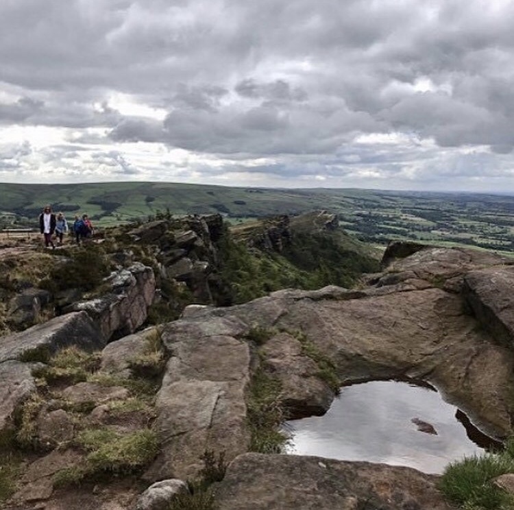
After stopping for photographs at the trig point, we continued the walk along the final section of the Roaches. It is here that we were greeted with some fairly spectacular rock formations and a welcome shelter from the wind. I discovered a wonderful view over Staffordshire and the surrounding countryside from here.
Return to Roaches Road
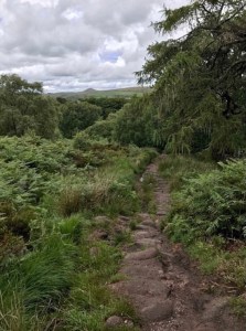
From this point, the path begins its decent down towards Roach End which is the end of the crag top walk. As we walked along, the path became paved once again and easier to walk on. It was a fairly straightforward journey from then on down the far hillside. As we approached the Roach Road, we noticed that the route continued across it and over a stone stile into woodland towards Lud’s Church and this is where we headed that Summer’s day in July. This adventure however ends here and focuses on the return back to the starting point at Roaches Gate.
From Roach End, it is a very simple route back to the starting point. The footpath joins the road heading back past a small car park on the left and it is from here that people follow this road back. It is approximately 2 miles to return to Roaches Gate. There is of course the option if people are feeling energetic, to walk back up across the Roaches and back the way they came.
Walk Summary
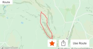
Distance walked: 4.26 miles.
Total Elevation Gain: 876 ft
Overall, I really enjoyed this section of the walk in the Staffordshire Peak District that day in July 2020. As explained above, the walk was never aimed at being a long one focusing more on the stunning views that this particular route has to offer. Staffordshire is fairly new to me in that this is the first adventure I have ever done in this region and I was more than happy with what I experienced that day. Coming away from the familiarities of my usual walking place was an eye opener for me as it made me realise just how much more of the Peak District there actually was.
As I mentioned early on in this blog, it is easy to get stuck in a comfort zone and become almost nervous to try new places for fear it may be a let down. It becomes almost a ritual to remain with the scenes we know and love so well and end up missing what is really out there. I’m not saying for a second that the old favourites are bad choices, or that we shouldn’t stay in a familiar walking spot. If this is what makes people happy then we have to do what is best at the end of the day. I just found that for me, taking the plunge of expanding my exploration locations worked in my best interest and made me want to try other routes which perhaps I would not have considered before.
The actual walk although involving some climbing and scrambling initially, was not a difficult one. The path along the top of the Roaches is clearly set out and easy going underfoot making it a very pleasant walk indeed. The scenery and surrounding countryside are stunning and there are spectacular views to be enjoyed on either side. To say that this crag is only approximately 2 miles in length, there is certainly lots to take in during the adventure.
I have since learned that there is much more that I didn’t see unfortunately, as at the time I didn’t have the knowledge about it. This includes an ancient 36 inch stone carving near the trig point, the ‘Winking Man’ a strange rock formation found on Ramshaw Rocks a short distance from the Roaches, the ‘Queens Chair’ a rock cut into the shape of a chair set on a boulder high on the cliff above Rock Hall and the ‘Hanging Stone’ on Forest Ridge. All of which I would like to see on my next visit hopefully.
Although this location is popular with walkers and climbers, it is important to bare in mind that there are no shops etc to buy provisions. If planning on doing this walk it is necessary to bring your own food and refreshments and plan accordingly. There are also no toilets. There is however a tea room known as ‘The Roaches Tearoom and Restaurant’ at Paddock Farm on the Roach Road at Upper Hulme. I haven’t visited here personally as yet but it is definitely somewhere I will consider in the future.
Lastly, I have to mention that when we did this walk in 2020, there was a section of the hillside down from the crag that had been severely damaged by fire. It was starting to recover by the time we visited but I could clearly see that the amount of damage was vast. According to signs put up near Roaches Gate it was apparently caused by a barbecue. It is now an offence to use barbecues in this location so bare this in mind if planning one during your visit.
I would like to Thank each and every one of you who reads my blog posts and supports me in what I do. It means a lot in so many ways. Thankyou, and I hope they help you in your explorations. Take care and see you soon for Lud’s Church and part 2 of this Staffordshire Peak District walk.
All photographs for this blog post were taken and edited by myself Lucy Bailey using iPhone 7 camera.
Local history regarding this area and included in this blog post were sourced from the following: http://www.thebmc.co.uk, http://www.roachestearooms.co.uk, http://www.ukclimbing.com, http://www.roaches.org.uk, peakdistrictwalks.net, letsgopeakdistrict.co.uk

One thought on “Trig walks: The Roaches – Staffordshire and the Peak District”