11th May 2021
It was bang on 6.30am when I awoke on Tuesday morning to the sound of rain pattering on the tent. For a split second, I had forgotten where I was. It was only as I gathered my thoughts and roused myself from semi consciousness, that the purpose of being here came into clarity. I was doing the Loch Ness 360 hike and I was already one day along the 80 mile trail. I laid for a good 10 minutes not wishing to move anywhere, the comfort and warmth of my sleeping bag and the sound of the rain making this all the more prominent. My alarm had been set for 7am anyway but now I was awake, I knew there was not much point in trying to get back to sleep. My intention today was to get washed, dressed, breakfasted and packed away by 7.45am and be back on the trail no later than 8am.
Slipping on my walking boots and unzipping the tent, I hastily looked outside. The rain was not actually as bad I thought. The sound on the tent upon waking had sounded much heavier as I’d lain there listening but now, as I pulled myself out through the doorway and stood gazing round outside at the surroundings, I realised it was only spitting which I suppose was a good thing.
Last night had been a late pitch up. It was gone 8pm when I had finally found a camping pitch where the ground was even remotely suitable. Then together with getting set up, preparing tea and a hot drink, I had finally climbed into my sleeping bag at gone 10pm. I remember feeling absolutely shattered and quite ill just before I’d fallen asleep and seriously hoped that come morning, I would feel well enough to continue the hike. Yesterday’s walk was originally meant to be 12.5 miles, but continuing on in search of a spot had brought me an extra 5! I suffer with sciatica and have for a number of years. Although leading an active lifestyle has improved it, I still suffer bouts every now and then mostly when my spine has been jolted or aggravated. Due to this and the heavy day yesterday, I had taken some paracetamol and an anti inflammatory just before falling asleep in the hope it might minimise potential damage. Now, it seemed to have worked a treat as I flexed my joints and walked around the tent. Apart from my legs feeling a little stiff which was to be expected and a bit of bruising on my hips from the hip belt of my rucksack, I felt ready to take on the day and all the excitement and amazing scenery that today was sure to bring.
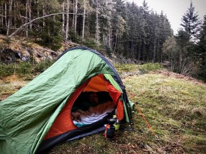
The night had not been a bad one and I hadn’t woken once during it. The rain nor the nearby trickling brook had disturbed me and I felt amazing after a really good sleep. I had at first felt apprehensive about pitching right on the trail. It had not been in my plans having hoped to find a pitch in the forest hidden from view. However, last night this had been impossible and I had had to make do with the first opportunity that became available. As far as I was aware, nobody had ventured past the tent once during the night and so far this still stood. Having daylight on my side now though did wonders to relieve that fear! I have always been fascinated by how much light changes your perception of things and how it feeds your imagination. Even the most beautiful of locations can so quickly become your enemy when darkness falls and your imagination goes into overdrive. It is something I have been trying to conquer for years and is still on occasion, a work in progress.
It was soon time to have breakfast and a hot cup of coffee. Whilst I waited for my water to boil, I headed over to the viewpoint and gazed through the pine trees over Loch Ness. Up until this point, the trail does not go within viewing distance of the Loch and it was only as I dropped down over the Abriachan Forest Trust Trails that I was able to catch just glimpses of it. As I looked on now, I was met by the spectacular formation that ran along the Great Glen fault line, lying still and moody and shrouded in early morning mist which swirled slowly by. As I stood there, it was hard not to think about it’s depths which are said to reach as far as 754 feet (229.8 meters). There is a theory that the Loch has depths reaching well over 850 feet but as yet, due to it not being fully explored, the current record stands at 754 feet. Straight across from where I was pitched was the village of Dores on the opposite side of Loch Ness. It filled me with excitement once again at the thought that I would be there in the next few days.
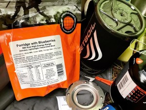
Breakfast today consisted of porridge with blueberries, a high calorie Expedition Foods freeze dried meal from a ration pack I had purchased before the trip and a double chocolate mocha coffee. I was pleasantly surprised upon trying it for the first time, that it was actually delicious! There is nothing worse than not having food you enjoy on a hike and it was always a big worry for me on previous walks whenever I selected foods to take. It was largely due to this that I had stuck with sandwiches and picnic food for so long. Now however, I had been kind of forced to make the transition in order to keep my pack weight low and not have to think about food going stale. I have to admit now that it was the best decision I ever made and I will be using these foods for the majority of any future long distance hike I do. After finishing breakfast, washing my utensils in the nearby stream and packing away, I was ready to begin the day. The time was now 8.10am and the trail was calling.

Leave No Trace
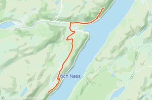
Overview and day 2 walk route
The aim of today’s walk was to make it past Grotiag which is a small cluster of farm cottages just past Balbeg on the Bunloit Road. That was the original plan anyway. Due to the fact that I had already walked 5 miles of today’s hike yesterday however, I was hoping to try and get further to remain ahead of myself in case I needed to cut a day shorter later down the line for whatever reason. The hike today would be approximately 11 miles and would begin from where I camped in the Abriachan Forest then proceed along the Great Glen Way dropping down through more forestry to Temple Pier. This was a considerable reduction in distance from the original day hike which was set at 16 miles. From there the route carries on through Drumnadrochit and Lewiston where I planned to buy lunch, and climbs back up steeply through farmland and more forestry towards the Bunloit Road. It is worth knowing that the section of the Bunloit Road that the Great Glen Way uses is extremely long! The majority of the day was spent walking on road. Upon reaching Grotiag, the route then continues along dirt path as it heads up through woodland and back into forestry as it heads towards Glenmoriston on the outskirts of Alltsigh. My intention was to reach Grotiag and attempt to walk a little further in order to find a suitable camping pitch in the woodlands around that area.
Abriachan Forest to Drumnadrochit
It was still raining as I hit the trail first off that morning. I had ensured that all my gear was carefully placed in adequate dry bags and that my rucksack was covered properly with its protective rain cover so as not to end up with wet kit later. It is surprising how quickly this can happen if adequate care is not taken when packing away gear and will make a huge difference to both pack weight and more importantly, your overall experience of a hike. The trail continued along the straight track which ran parallel to Loch Ness, before heading into forestry once again. As I set out along the trail that morning I once again had that amazing tingle of excitement that was all too familiar when starting a walk. I really felt free out here away from all the hustle and bustle of everyday life back in Sheffield. It was amazing to only have myself to worry about. It didn’t matter in the slightest that it was raining and I was wearing men’s waterproof trousers, that I had no makeup on or that my hair was a mess! It was my time to be completely myself without a care in the world… That’s truly one of the best parts of hiking and the great outdoors.
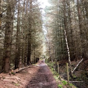
Just before entering the forest ahead of me, I came across a notice board at the side of a Great Glen Way marker and stopped to read it. It talked about this section of the forest and how in 1941, approximately 2,000 Canadian Lumberjacks had set up camp in this location to fell pine trees in order to provide timber for the war effort. At the time it was World War 2 and it was more cost effective and efficient to harvest British timber than import it from the USA. Many lumberjacks remained in Scotland after the war, married local girls and set up home rather than return to their native Canada. On close inspection of the trail in this location, evidence of their work remains to be seen. If you look closely, old sections of track is still present from the trains which were used to carry the timber to its respective location.
The forestry here is very attractive and I couldn’t help but marvel as I passed through. Just shortly after entering, the path begins to descend and involves crossing various streams to continue on the route. Although there are wooden footbridges for the majority, there is one crossing where there is no bridge at all. It involved using various rocks placed there as stepping stones and care should be taken. On the day I crossed, the water flow down from the steep imposing hillside was low, and I crossed easily but depending on the time of year and of course the weather, this might not be so. The path in particular was slippy in places along this stretch of the route.

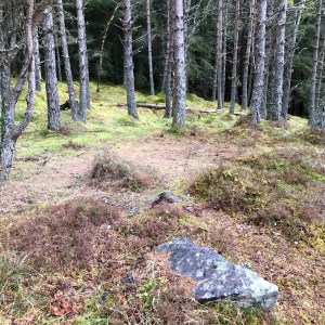
It is around this point that I came across the first opportunity to wild camp since leaving my spot. It was only 10 minutes into the forest and would have been an excellent place to pitch with a stunning view over the tree tops down towards Loch Ness. Again, it was slightly off the trail but it was a large spot with room for at least 3 tents and a handy bench that someone had made. A part of me wished that I had made it the extra 10 minutes further last night and found the spot as it looked so beautiful and tranquil, but I guess I wasn’t to know what was round the next corner and being so fatigued and aching, I just couldn’t take the risk. For all I knew there might not have been anything for miles! I made up my mind that in my future hike of the Great Glen Way, that was definitely going to be my camping spot.

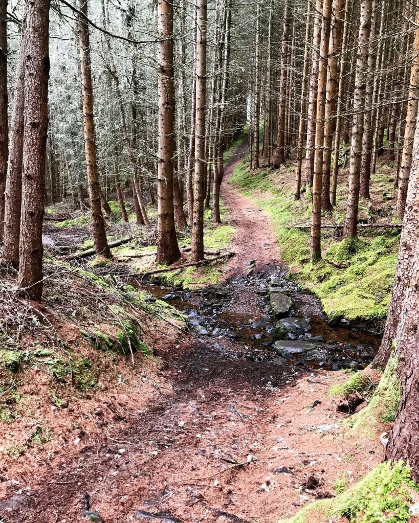
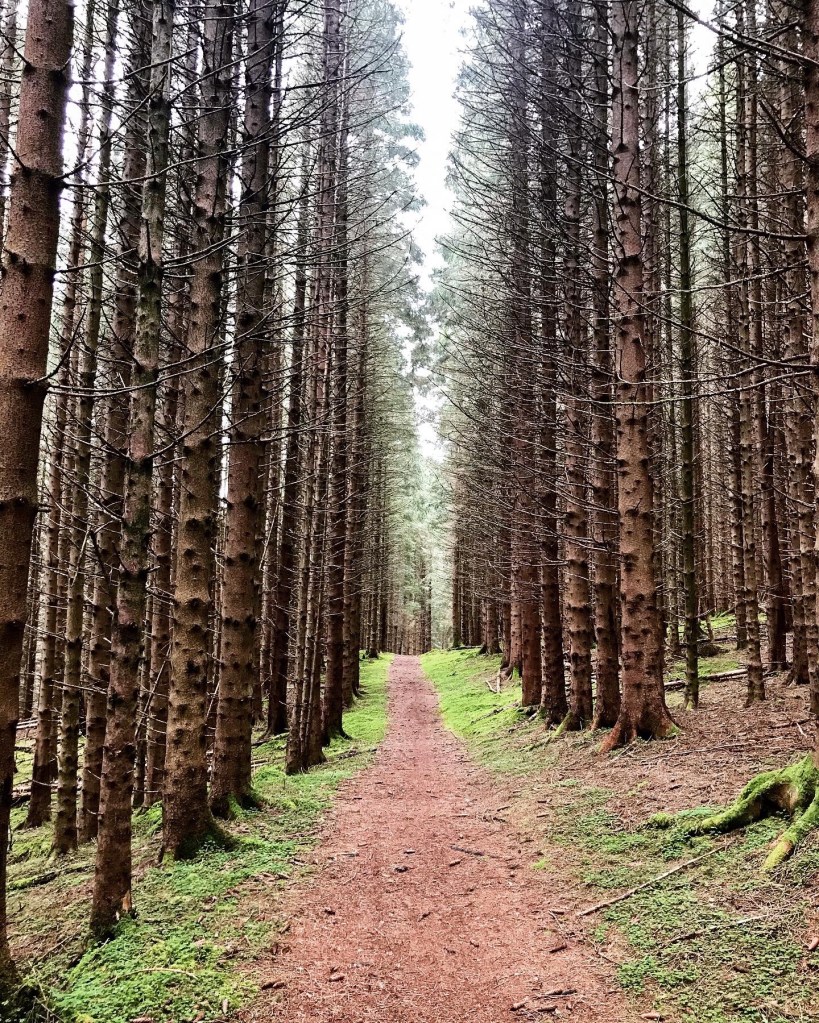
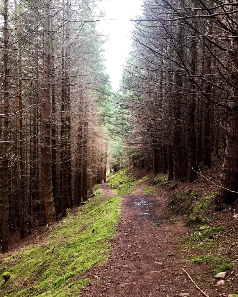
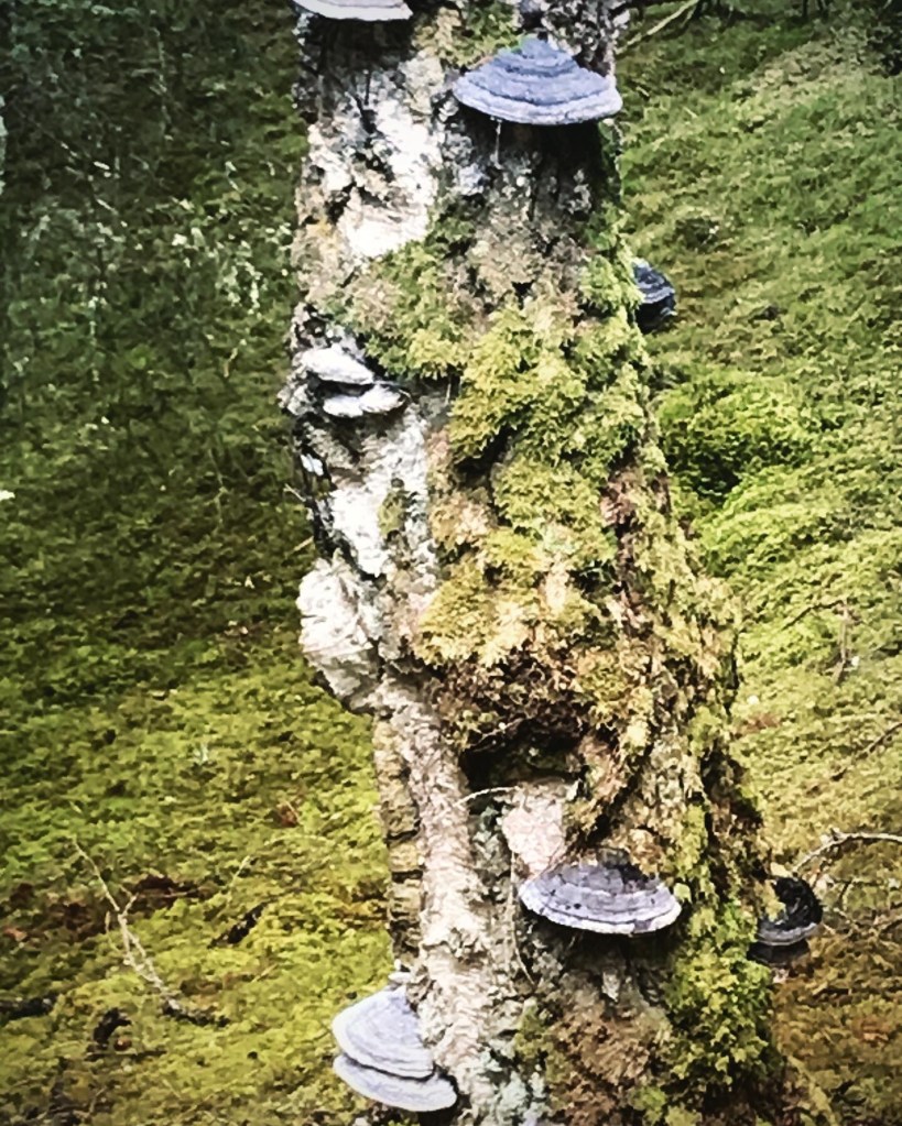
The path from then on continues onwards through the forest before starting to drop down quite steeply in places. I found during this stage that the path zigzags a few times and has some extremely sharp bends which almost saw me lose my footing and fall. The ground underfoot was very muddy on the steep decline which was difficult to remain upright with the weight of the rucksack pushing me forward. Extreme care was required during this section of the trail and I used this opportunity for a short stop off break to fill my reservoir bags from a nearby stream. The forest here however, is a very attractive part with the smell of the pine in sharp abundance. The path was dotted everywhere with fallen pine needles and the trees either side grew so thick and dense it really added to it’s mysteriousness. What I loved most was the vibrant green of the moss against the reddish tinge of the mud path which appeared to glow in the shafts of light which found its way through the firs. I noticed that the atmosphere felt really humid and damp here and the tree trunks of many trees were coated in mosses and fungi of all shapes and sizes. I have always loved a pine forest. Despite them being dark and mysterious in parts, it always feels like I am in a story book whenever I go in one. Another magical aspect of exploring.


Leaving the forest through a metal gate, I entered a large area of open farmland with fields on either side of the path. The views here over the Loch are incredible with a clear viewpoint directly across the water to Urquhart Castle, an iconic landmark at Loch Ness. The castle has a lively history which can be accessed on a wide variety of websites if readers wish to know this information and can be visited by purchasing tickets on dedicated sites. The castle was the only castle in Scotland to withstand invasion by the English for the longest period of time and is now classed as a ‘noble ruin in a majestic setting’.
From here, the Great Glen Way continues on through the Tychat Estate, following the cart track through open farmland. There are livestock grazing in many of the fields passed through on this stretch and I passed through a number of farm gates as I walked. The landscape really opens up over this part with splendid views over Loch Ness and the surrounding areas. The road which leads into Drumnadrochit runs parallel to this path and can be spotted coming into view from this location. I could see that after a short distance ahead, the trail once again meets the road and that I would once again be following road right into the village. It was at this point that I met my first hiker of the day, a man walking towards me in the opposite direction and also my first Loch Ness 360 cyclists who were 2 women with large rucksacks, pulling their way with difficulty up the tough dirt track. I have to admit that I didn’t envy them and what lay ahead. The drop down out of the Abriachan Forest had been a steep one in places and I couldn’t imagine what it must be like to cycle or climb in the opposite direction. I didn’t say anything to them about the accent and secretly wish them well in their travels. The trail leads onwards behind a house, follows the contours of the road for approximately a kilometre before eventually becoming part of it at Temple Pier.
There was an interesting notice board at Temple Pier in which it gives information about John Cobb and his attempt to break the World Water Speed Record. In September 1952, John Cobb used a jet propelled crusader on the Temple Pier location of Loch Ness and had reached 200mph speeds when he crashed and was tragically killed in front of horrified onlookers who had gathered to watch the show. He already held the world champion title for land speed records 3 times.
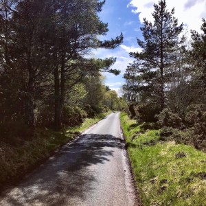
The next stage of the route consisted of road walking into Drumnadrochit for the next mile and a half. It was still raining and once again I could feel myself being jolted as I walked along due the rucksack weight and the impact of my feet against the concrete. Just as I rounded a corner, I was once again met by the 2 male hikers that I had met during my travels yesterday. We discussed our respective camping places and the lack of camping spots before wishing each other well and continuing on our journeys. The time was 11.15am and according to my Strava GPS, I had walked 4 miles already. Not bad going really. The walk along the road to Drumnadrochit was probably one of the most boring sections of the day. The road was an extremely busy one and due to the thick trees either side, there was no view of the Loch or surrounding countryside. Although I had been aware of the road walking beforehand, I was beginning to really despise it. I was grateful when the first buildings of Drumnadrochit came into view and I could take a well earned break with some lunch from a nearby outlet.
The village of Drumnadrochit is relatively small. Noticeable attractions are the Loch Ness Centre and Exhibition, Nessy Land and Loch Ness Cruises, a gift shop, village green, post office, public houses and a number of shops and supermarkets. I considered visiting the Exhibition Centre but decided against it when considering the hike ahead, as I was determined tonight to find a suitable camping pitch and get set up early. The centre is supposedly interesting however with lots of useful information about the history of Loch Ness and also features a display about an interesting fellow who dived to the bottom of Loch Ness in search of the rumoured monster. It uses high performance lazers and special effects to tell stories and give factual information about the Loch. Although I didn’t visit on this occasion, it is definitely something I will consider in the future when walking the official Great Glen Way.
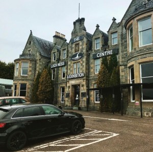
After passing the Exhibition Centre the trail continues over the River Enrick and follows the road down past the War Memorial. From here, you can see a selection of shops which are useful for stocking up on supplies and other materials, and also a Post Office which serves also as a cafe. I decided to stop here for a while and ordered a breakfast sandwich, coffee and a chocolate brownie. I have to admit that I was impressed with the service here. The staff were very friendly and prompt and the food was delicious. They also sold the best chocolate in Scotland! I recommend this cafe to anyone walking the Great Glen Way.


Drumnadrochit to Grotiag
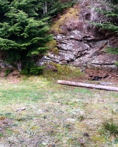
After finishing lunch it was soon time to continue along the trail again. The route follows the main road through Drumnadrochit and onto Lewiston where it crosses the River Coiltie by a stone road bridge. It is just shortly beyond the bridge that the route turns off sharply onto a farm track on the right. Following this, it begins the first real climb of the day as it heads up towards a farm house and camp site and continues on into forestry where I decided to sit and rest. The pull up the hill from Lewiston was a killer with the rucksack and took considerable time. The path gradually becomes a dirt track as it winds ever higher with spectacular views back down in the direction I had walked from Drumnadrochit and I could see right back as far as the Abriachan Forest where I had camped the previous night. It all looked so far away and it was hard to imagine that I was there only this morning. As I climbed though, I was met with the spectacular sights of the rocky crags high above me which both beckoned and taunted me with every step.
It was here that I met a man who was walking the Great Glen Way in the opposite direction. He asked me about where the nearest campsite was and stated that he had set off from Fort William at 4am the previous day. He had taken the high route out of Fort Augustus, to which he said there was not a single camping spot to be had. He had made do by sleeping in bracken and other undergrowth before continuing on along the trail.
The next section along the Great Glen Way from this point is probably my least favourite of the entire route and nothing could’ve prepared me for how challenging it really was! Approximately halfway along the forest track, the path turns a corner and starts a gradual uphill climb past some secluded cottages where two teenage lovers were having a heated argument outside at the trail. I couldn’t help but smile as I went past. It then heads up quite steeply towards a small car park and a gate which leads out onto yet more long and imposing country lane. The Great Glen Way then uses this extremely long, brutal road all the way to Grotiag, a cluster of small houses, a farm and a glamping site all within close proximity of each other. The road in question was the Bunloit Road and stretched on for approximately 4 miles. It was single track with passing places along it and there were times that I had to dodge incoming and passing traffic.
By now the rain had stopped and was now glorious sunshine meaning I once again had to remove quite a few layers of additional clothing. As I walked along, I began to feel the familiar aches and pains of the previous day, the road being ruthless in more ways than one. Road, I had found during this trail was plentiful and was so difficult to walk on for such long periods. It wasn’t that the road was particularly hilly, in-fact, after the tough climb out of Drumnadrochit and the forest, it was a gradual slow decline all the way to Grotiag, but the sheer length of it and the constant repetition of feet slamming concrete for just over 4 miles was torture. The agony felt in the knees and thighs during and following it I truly cannot describe and it really takes the energy out of you.
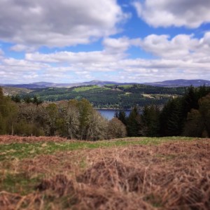
I truly believe that if it wasn’t for the beautiful scenery admired from the road on either side, this section may have got the better of me. I have viewed several video blogs of other hikers who have walked the Great Glen Way and Loch Ness 360 trails and it had occurred to me at the time of my own walk that hardly any had filmed this stretch! Those that had had only shown a brief moment of it. I now fully understood why as it seemed to stretch on forever and for most will probably have been their least favourite too. After a long while, there is the opportunity to come off the road and follow a narrow footpath running parallel to it alongside some bright gorse bushes. At least on this I didn’t feel as threatened by oncoming traffic and I was able to enjoy the scenery as best I could. To my right I could see the vast shape of the Meall Fuar-mhonaidh, a mountain which gives a spectacular view of all the Loch Ness location. There was still snow on the tops and it looked quite picturesque in the afternoon sun. There is a footpath at Grotiag which leads past the Great Glen Way and heads up the Meall Fuar-mhonaidh for anyone who wishes to take a detour from that point on. Be aware though that once at the top, the same route has to be utilised to get back and the whole detour adds around 5 miles onto your day.

Upon reaching Grotiag, I passed a camping/glamping campsite on the right called Ancarraig Lodges which was temporarily closed due the Covid 19 pandemic. The site actually looked quite beautiful with a stream running through the ground, small lakes and the lush greenery. A row of farm cottages lay on my right with a working farm and then finally the trail leads off the road once more. It was here that I had made my original day 2 check point and I could’ve chosen to camp here if I really wanted to. However, due to walking far less miles today, I opted to press on and try and get a few extra miles in.
Grotiag to Glenmoriston
At Grotiag, at the point where the path leads off towards the Meall Fuar-mhonaidh, the Great Glen Way takes a sharp left turn through a wooden farm gate and starts heading downwards towards a pretty stream with a stone bridge leading over it. I spotted a perfect little place here for a wild camp and it had obviously been recently used as there was a fire pit by the side of it. I felt at the time, that I had not walked quite far enough for the day and so pressed eagerly on however, it is worth baring in mind this spot for future reference. The trail begins to head uphill again at this point and took me into woodland where there were quite a few spots to choose from. Again I chose to keep heading onwards and upwards.
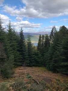
Before long, I began to head into thick forestry once again and passed through a number of high metal gates along the way. The trail from now on consists of a steep uphill mud path which follows the contours of the Loch Ness through dense forestry. Along the route I was gifted with the sights of the forest and occasional glimpses of the Loch whenever there was an open space or gap in the tree line. There were also tiny trickling brooks which tumbled down from the mountain side and crossed the path. Although very pretty, this section of trail was tiring especially after the long period of road walking. I made up my mind that the next suitable camping spot I came across would be mine for the night. It was approaching 6pm by this time and I hoped to be settled and had tea early. Tomorrow was set to be a long day and an early start was required.
Camping spot
I came across my camping spot by chance as I climbed ever higher along the forest path towards Glenmoriston. The intention had been to walk slightly further but when I saw the location, I found it to be perfect for what I needed. Again, it was right at the side of trail but after last night I didn’t feel quite as apprehensive about it. The time was now 6.30pm and it felt right to be pitching about now and getting settled. This location had 2 places that were suitable to pitch tents, each one being on opposite sides of the trail. There was also a bench and a look out place in which there were views right down through the forest to Loch Ness. The path was quite high up the mountain side and so the views really were something. It was a beautiful, sunny evening with a gentle breeze and I felt that a lovely chilled and relaxed evening was in store.
The first pitch I looked at on the right side of the trail was my favourite and I moved over to take a better look. I soon changed my mind however when I glanced up at the trees which grew all around. The pitch backed onto the mountain side and had enormous tall fir trees which grew dense and thick all the way up the mountain. However, just above the pitch there were about 5 toppled firs which were now balancing on the branches of other trees and looked like they could fall any moment. I decided not to take the risk of being speared during the night should a tree branch give way. The fir trees in these parts are huge and could cause some serious damage if ever one fell and to be honest, I had noticed that many trees looked ancient and unsafe. I quickly crossed the trail and set up my tent at the side of the wooden bench where I felt confident that nothing untoward would happen.
Tea on night 2 consisted of Expedition Foods Spaghetti Bolognese which was really nice and filling and a hot chocolate. I also had a chocolate bar which I had bought from the post office cafe in Drumnadrochit earlier in the day. I sat on the wooden bench gazing down at the Loch while I ate and thought about the events of the day. It was here that I noticed that I had no mobile phone signal in this location and my phone and Strava app was running purely on GPS signal only. I could however make and receive telephone calls, I just couldn’t access any social media or any of the apps on my phone. It is worth baring in mind when thinking of camping in this location and many other sections of the Loch Ness 360 trail. There are lots of parts throughout it where a mobile phone will only run on GPS or will have no signal at all.
As I settled down in my tent that night I felt content and happy with the days events. Once again I had managed to hit the milestones of the day meaning I was on good course to make Fort Augustus tomorrow where I had booked a room in a Youth Hostel for the night. Just before I went to sleep, I refilled all my reservoir bags from a nearby burn which ran down from the mountain side on the opposite side of the trail. It really was a perfect camping spot and probably my favourite wild camping spot of the whole hike.
Walk Summary
Distance walked: 11.17 miles
Elevation gain: 1,291 feet
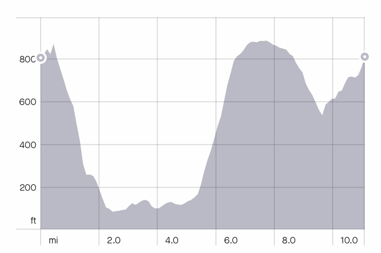
Upon reflection of day 2, I have to admit that I found it to be very challenging due to the amount of road walking involved. Most of the distance covered on this day involved hiking on the road which is not my favourite terrain. Although I had an idea that some of today would be like this, I hadn’t anticipated it to be quite as much. It really took it out of me with carrying the heavy rucksack and it made me realise that I was lucky in a macabre kind of way that I had been forced to walk the considerable longer distance yesterday. On day 2 I managed to cover just slightly over 11 miles yet I felt just as tired in the evening as what I felt upon finally finding a camping spot on day 1 which was almost 17 miles of hiking. It just goes to show that what appears easier may not actually be the case at all.
Overall though, I thoroughly loved the scenery throughout day 2. The forestry passed through and the breath taking view points over the Loch Ness and from Drumnadrochit were what makes the hard work worth it. My only regret of the day was perhaps not visiting the Meall Fuar-mhonaidh which is a very popular detour point on the trail. I feel now looking back at the fact that I didn’t walk much further than Grotiag, that I could have managed the extra 5 miles and still made it to my current camping spot. There were also plenty of other spots available should this have proved difficult, but I guess hindsight is a wonderful thing. Future hikes of the Great Glen Way will be much better prepared and planned based on the knowledge gained whilst doing this hike.
Once again, I would like to offer heartfelt thanks to everyone who has supported me so far in this incredible journey both by reading the blogs and by messages of support and advice throughout the trip. I try to keep the blogs as informative as I can in order to both tell my story of the Loch Ness 360 and to aid others who may be considering doing it. All messages of support received during this time and all the advice I received from people with firsthand knowledge of the Great Glen Way has helped me enormously and I value every word immensely. Thankyou so much…
If you enjoyed part 2 of the Loch Ness 360 series then I hope to hear from you again upon release of day 3 and I hope it helps in any future hike you may have planned.
All writing, editing and photographs have been taken and created by myself Lucy Bailey. Photographs were taken using iPhone 7 camera and then edited on Instagram using editor tool. All images can be viewed on my Instagram account at soloexplorer23. Distance and elevation was tracked using Strava app. All factual information was sourced from public Loch side notice boards and the following websites:
