13th May 2021
Waking up in Morag’s Lodge at 8am came around way too fast. It had been such a comfortable night that I could’ve stayed there forever. After evening meal, I had spent the remainder of the previous night relaxing on the bed making the most of my time in relative luxury, something I would not experience in the next coming days on the trail.
I had considered taking advantage of the on-site bar and ordering a drink but the current Covid restrictions at the time had meant no drinking in the bar area, with beverages having to be consumed either in the bedroom or outside on the garden decking area. With this in mind, I had decided against it. One drink would most likely have become another and before I knew it, I would have woke the following morning with a thumping head. Hardly the best way to start the day!
I have to admit that I felt amazing after a good night’s sleep. Considering that I had walked 45 miles of the hike already, I was surprised just how well my muscles had gotten used to walking the long distances so quickly. It appeared that the initial aches and pains had now passed and with each waking day, I was beginning to feel stronger. Despite feeling ghastly as each walking day drew to a close, the overwhelming feeling of accomplishment truly cannot be underestimated. The beautiful scenes of the Scottish Highlands are what makes all the effort worth it in my eyes, however no one ever said a trail hike was easy.
Checking my power devices, I was pleased to see that they had all charged fully overnight with no problems. One of the main worries I’d had during this hike so far was if I would have enough power to keep my devices running efficiently or if any of my power leads would break. With a first time trail hike and the uncertainty of what to expect, I guess this is a common thing. Experience is only learned from experience…
As I headed down the narrow passage to breakfast I had a spring in my step as I caught sight of the morning through the open side window. It was glorious sunshine and so far, not a cloud in the sky! This was how I liked it. Yet a lot can be said of Scotland’s temperamental weathers and the saying “You don’t come to Scotland to sunbathe” is definitely an understatement!
I hike Scotland for its rugged terrain and endless rolling hills, something which sounds so ordinary you would imagine it is not much different to any other National Park in the UK. There is however something special about the Highlands which draws me in so much that even the bad weather is a small price to pay. Yes, at the time it is challenging and I cursed it to the fossil when I ended up saturated to the bones and severely midge bitten on a previous hike to Steall Falls in August 2020, but the sheer vastness of the open Glen and the rugged, snowy mountains all around even in the late Spring captures me by the heart.
I have never felt as free as I do when I’m in Scotland… That said, when the weather is good and the sun is out in the Highlands it is a special bonus and for me, there was no better place than Fort Augustus to have the best sunshine days. I was so looking forward to photographing the famous lochs at Neptune’s Staircase on the Caledonian Canal as I passed through.
Breakfast at Morag’s Lodge was enjoyable and thoroughly set me up for the morning. I enjoyed a friendly chat whilst I ate with the lady who had shown me to my room the previous evening and I had shared my walk route with her and my plans for the next three days. After breakfast, it was time to pack up my equipment, take advantage of the glorious power showers there and set out on today’s adventure.
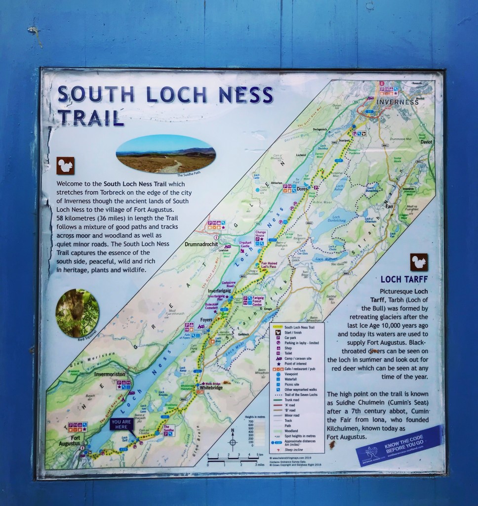
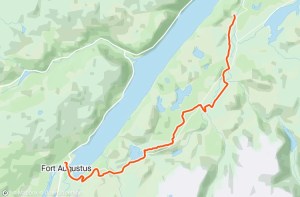
Overview and day 4 walk route
The aim of today’s hike was to make it from Fort Augustus to just before the village of Foyers on the South Loch Ness Trail. I was still unsure exactly where I would camp tonight but I had a rough idea. I knew that I couldn’t camp in the village but hoped to find a spot somewhere close to the river in between Whitebridge and Foyers.
Today’s route would take me along the shoreline as it passed through Fort Augustus and would climb higher into the mountains on the South side of Loch Ness through to Loch Tarff. From viewing the Loch Ness 360 Trail Guide, the trail heads inland at this point as it weaves through the mountains into open, rugged terrain and there are no views of Loch Ness for quite some time. There is quite a steep and backbreaking climb up the mountains before reaching the summit which the trail passes through and on to the Suidhe Chuimein, an iconic high point which promises spectacular panoramic views especially on a clear day.
It then drops down to the Whitebridge Plantation and follows the General Wade’s Military Road for quite some distance until it reaches Cumbrack Burn and the Allt Breineag, two large rivers which the trail crosses. From this point the trail proceeds to follow the Ardochy Road into the village of Whitebridge before meeting up with the River Foyers. It then continues along farm track which runs parallel to the river past Dell Farm and into open moorland.
I had planned to set up camp somewhere along this section past Dell Farm as I could see that it was out of the way of civilisation and there appeared to be a good water source nearby. Due to the fact that I would not be passing any shops on the route today, I had paid for a packed lunch to be prepared by Morag’s Lodge to save buying food in Fort Augustus in the morning. Evening meals and breakfasts were not an issue due to carrying freeze dried meals in my rucksack.
Area’s passed through on the Loch Ness South Trail are as follows:
- Fort Augustus
- Whitebridge
- Foyers
- Inverfarigaig
- Torness (Fair Haired Lads Pass)
- Dores
- Torbeck
- Inverness
All in all, today’s hike was set to be a good one with approximately 15 miles to cover. I wasn’t too sure of a time that I would reach my camping location but my intention was to get pitched up and settled into my sleeping bag after tea. I knew that I would once again be absolutely shattered by the time the day was done having walked 15 miles and I only hoped that the ground would be suitable. The area on the map looked to be open pasture and seemed the best location around that area, but as mentioned in my previous blog posts, I was fast learning that this means absolutely nothing. I guess only time would tell…
Fort Augustus to Loch Tarff
By the time I left Morag’s Lodge that morning and begun the descent down the steep road into the heart of Fort Augustus it was gone 10am. So, a very late start to the day… I have to say though, sleep is very underestimated when doing long distance trail hiking and I had well and truly made the most of it, savouring every possible moment that I could. It had worked wonders for all my aches and pains and I set out that day with clean clothes and a fresh mind.
Morag’s Lodge is situated on the Great Glen Way Trail itself and so I was fortunate enough to be able to get straight back on the trail as quickly as I had left it. Following the iconic Great Glen Way markers as they directed me down the hill, I headed towards the village knowing that my time following them was almost coming to an end. It was a strange feeling, a mixture of sadness and pride. Pride at knowing that I had completed 45 miles of the Loch Ness 360 Trail and was over halfway to completion, and also a jolting sadness when I thought of all the amazing experiences I had enjoyed and the stunning, breathtaking scenery which I would soon be leaving.
For the benefit of this blog post and for anyone reading this before any of my others, I will say that the Great Glen Way continues into Fort William from this point but the Loch Ness 360 Trail doesn’t use it further. It continues on to go full circle around the Loch Ness by following the South Loch Ness Trail from here onwards.
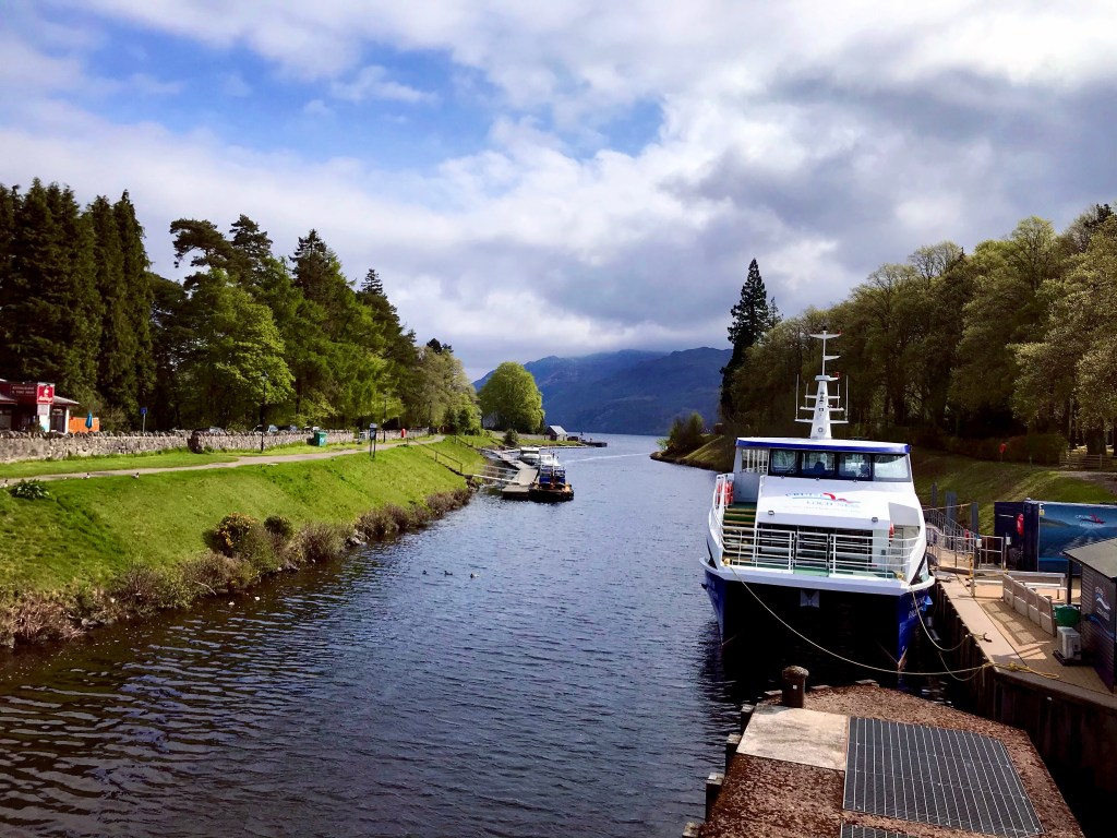
Fort Augustus is a village situated at the southern west end of Loch Ness and is one of the main tourist attractions of the whole area. It has the Caledonian Canal with Loch Ness Cruises offering tourist boat trips out on the Loch, a wide variety of shops, eating outlets and public houses, and stunning views of the southern end of Loch Ness and the surrounding countryside, moorland and mountains. On a previous visit here in 2010, I had treat myself to fish and chips and sat close to the lochs at Neptune’s Staircase whilst I ate. Unfortunately, due to it being so early in the day I could not take that opportunity today and felt slightly disappointed because of it. They were absolutely amazing fish and chips!
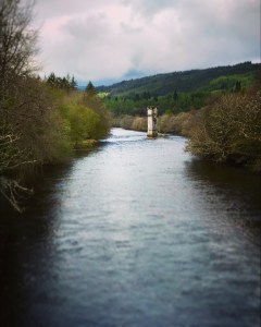
Crossing the River Oich that morning, I stopped to gaze over the stone bridge down the vast stretch to Loch Ness. Standing tall and proud was the large bridge pillar in the centre of the River Oich which still looked as beautiful and untouched as it had 11 years ago. It once formed part of an old bridge which was built in 1903 to carry railway tracks from Fort Augustus Station to Fort Augustus Pier and from there, passengers could catch a steam boat which would transport them the full length of Loch Ness right to Inverness. Despite the train service stopping in 1933, the bridge remained but was left to ruin. Today, that single pillar viewed from the main bridge is all that remains of yet another fantastic piece of Scottish history.
Just a short walk beyond the River Oich is the bridge which leads the way over the Caledonian Canal. From here, the spectacular lochs at Neptune’s Staircase can really be enjoyed in their finery. If I’d had more time that day and not such a late start, I may well have ventured up the staircase and spent a little more time here but unfortunately, not today. I decided to save that for another future adventure and continued on my way in order to get in some real miles before I stopped for lunch. I did however pause briefly to enjoy the views over the opposite side of the bridge where the cruises depart from. As I stood there, I thought about what an amazing addition to this hike it would’ve been if I had been able to throw in a Loch Ness Cruise… Dreaming would never get me anywhere however as I would need to take a complete rest day here in order to really get the most out of Fort Augustus. The journey must go on.
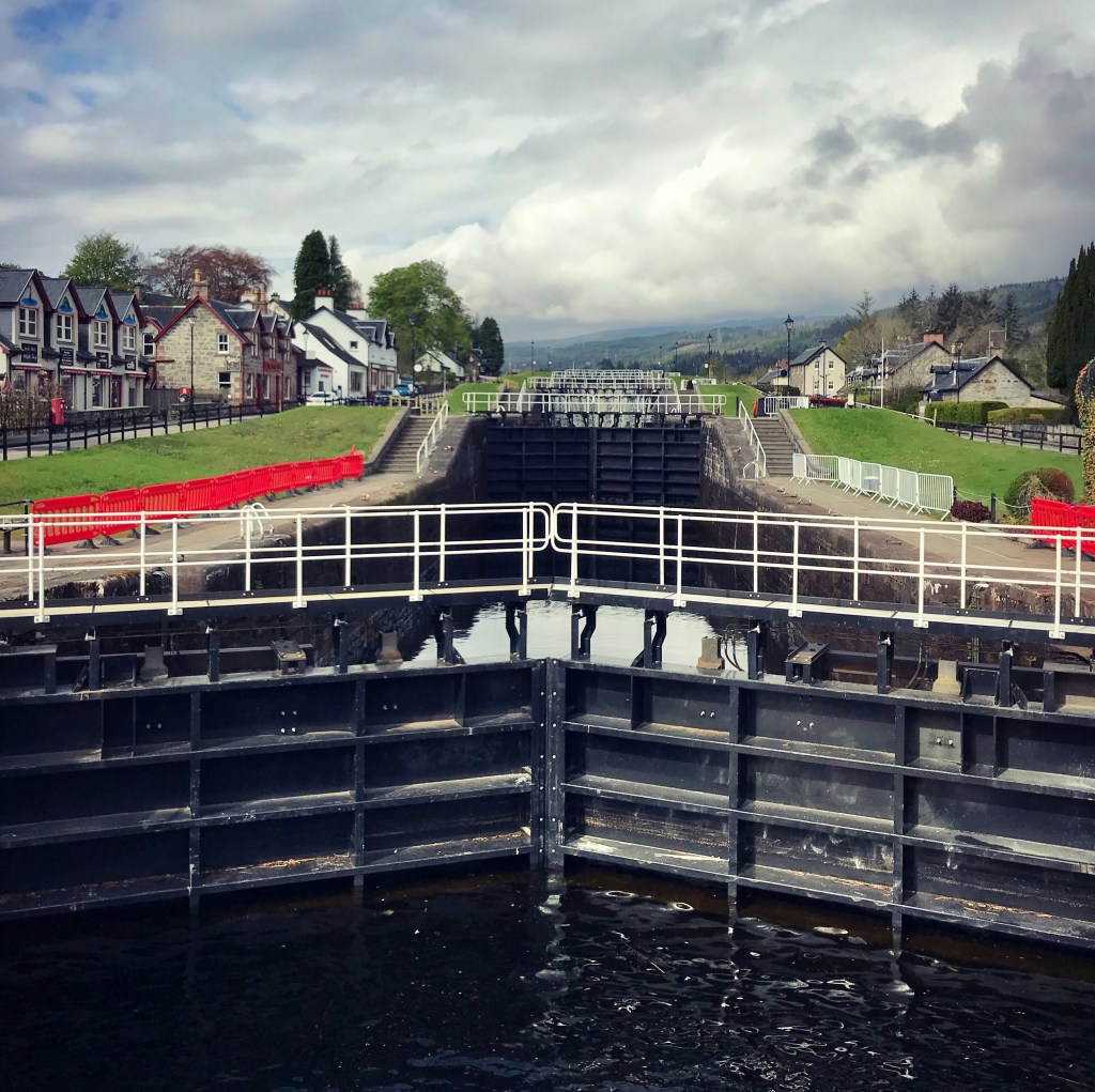
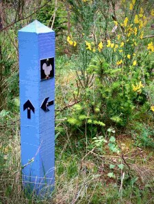
It is at this point that the Loch Ness 360 Trail leaves the Great Glen Way which turns right at the bridge and continues along to Neptune’s Staircase and follows the Caledonian Canal. My route required me to continue over the bridge and follow the General Wade’s Military Road right through the village before crossing another bridge running over the River Tarff and arriving at a small gate leading through an open field at the shoreline of Loch Ness. From this point on, I was on the official trail route of the Loch Ness South Trail which is identifiable by a blue marker with a black squirrel symbol.
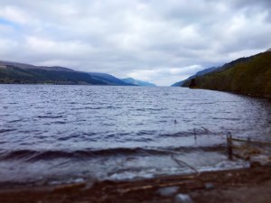
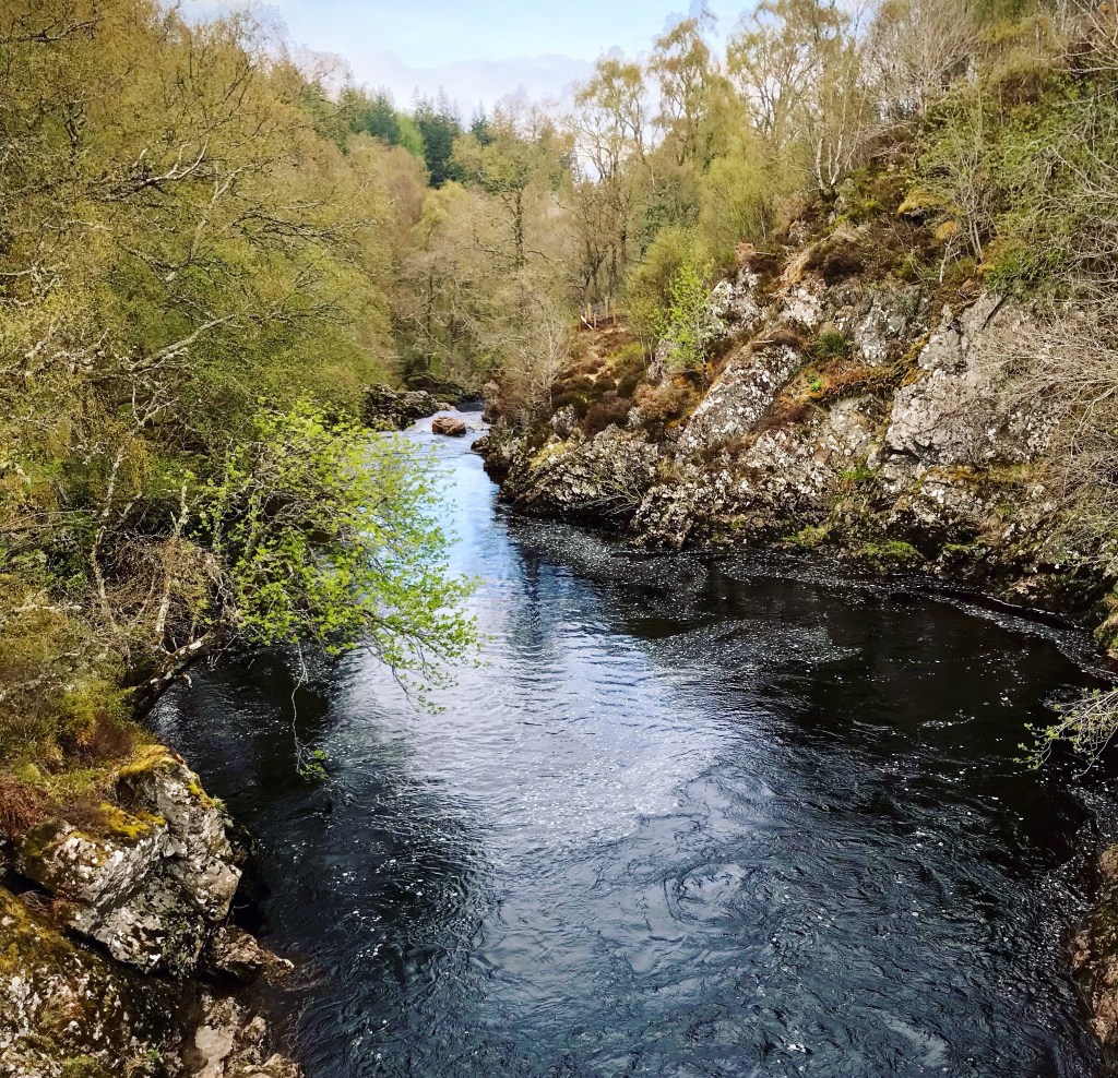
The footpath running along the shoreline is the closest that I have been to Loch Ness so far on the trip. As I walked along, I could see right up the vast waters as it stretched the whole length of Loch Ness towards the village of Dores which was so far away it couldn’t be spotted from where I stood. Although a beautiful sunny morning, a sharp breeze was in the air and the waters were forming waves which crashed to the shore. I was also watched closely by a flock of friendly yet inquisitive sheep who stared at me with their heads cocked on one side as though I wasn’t from this planet. After five minutes I thought it best that I bid them good day and continued on the trail.
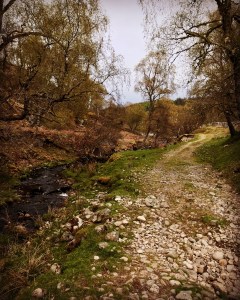
It is at this stage that I begun my first ascent of the day as the path begins a sharp, steep climb out of Fort Augustus and crosses the Allt an Dubhair, a fast flowing downhill river by way of a wooden footbridge. At the top of the hill, I reached the General Wade’s Military Road once again and crossed this as the trail continues on the opposite side. Once through the metal gate, I continued my ascent as the path climbed ever higher over Fort Augustus running parallel to the main road.
This stretch was quite a long one and I made two stops along the way to rest my legs which absolutely killed by the time I reached the top. The views from here are so worth the climb though and it was nice to actually see a true, clear view of Loch Ness and the surroundings without having to peer through forest pine. Fort Augustus looked magnificent from where I was stood right now all tucked away nice and neat like a model village surrounded by snow topped mountains right in the far distance.
As I looked closely further down the loch, I realised that I could just make out Cherry Island on the opposite side that I had spotted faintly through the trees yesterday. I remembered what the billboard had stated of the rise in water levels causing most of the island to become submerged and it certainly was obvious now. If it wasn’t for my pre existing knowledge of its existence, I probably would never have spotted it as it sat there lonely and still, and it would once again have become just a forgotten piece of land that for most people it already was.
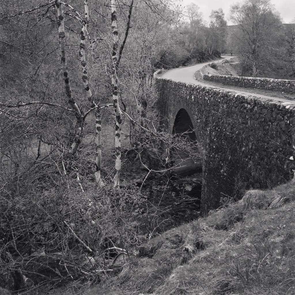
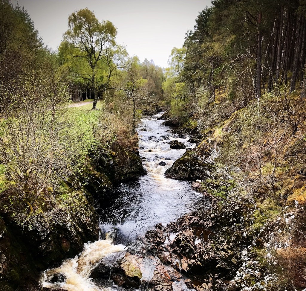
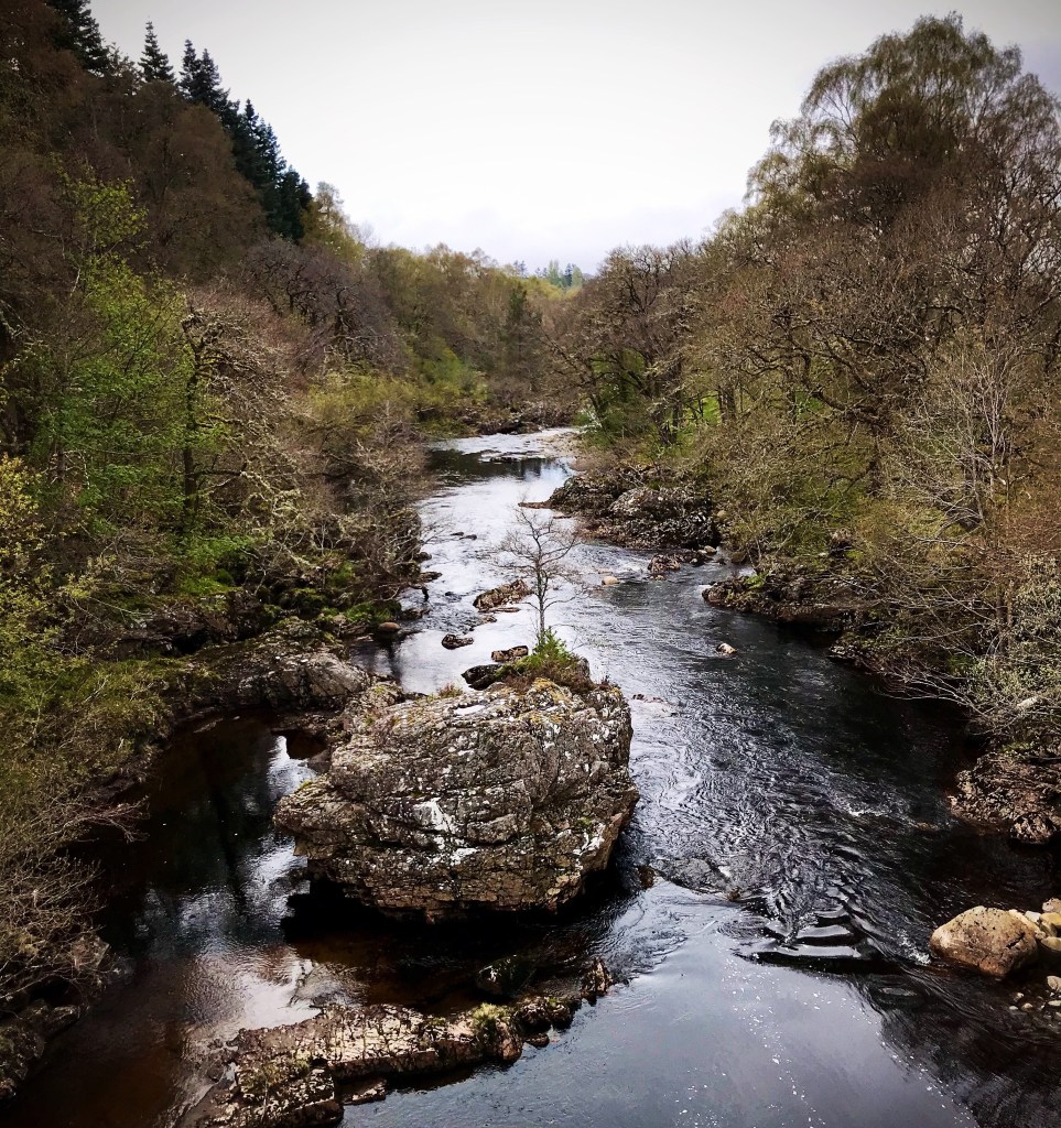
Continuing on, the trail skirts the back of a small wooded area and leads through a number of tall metal gates before meeting up with the General Wade’s Military Road once again. Crossing this and continuing on through another gate, I followed the path downhill until I reached a country lane and turning right here, came across an attractive stone bridge. The road bridge crosses the Allt Doe at this point which is another river and from standing here I could hear the loud, gushing cascades of a nearby waterfall. From here also, a second unused bridge can be spotted from the roadside. This small area is very attractive and after a sharp climb up the hilly road for approximately five minutes, I came to a gate on the opposite side with a Loch Ness South Trail marker at the side of it.
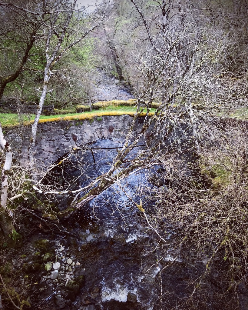
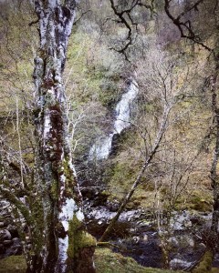
Upon going through the gate, I found myself at the top of a steep path leading downwards towards a very large and attractive waterfall which tumbled into the Allt Doe running along the bottom. It is a very beautiful and tranquil place to sit and enjoy the scenery, made even more welcoming by the presence of a single wooden picnic bench. I decided to take my first rest stop of the day here after much climbing out of Fort Augustus and settled upon a double chocolate mocha and a packet of cheddar and red onion crisps.
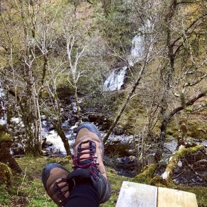
The waterfall in question I since learned is the Sputan Dubh which is far bigger than first anticipated. I found myself quite impressed by its beauty as I sat there on the picnic bench in this idyllic spot. After the tiring climb up the hilly trail, I found the sounds of the waterfall very therapeutic and I stayed approximately 20 minutes enjoying the views. I noticed a tiny path leading down to the falls but if I’m honest, it didn’t look to be very safe. However there was a man sat hidden in the bottom with a tripod and camera which really didn’t surprise me. The scenery out here really was picture postcard and unfortunately, my iPhone 7 camera really doesn’t do it any justice.
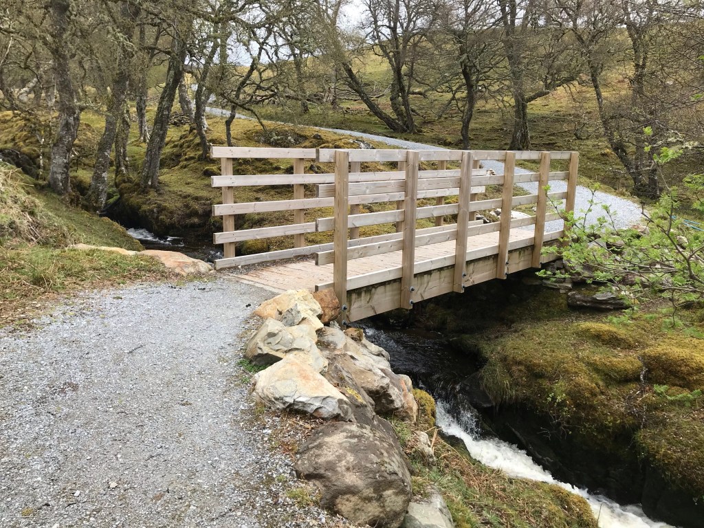
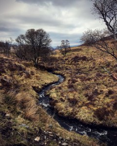
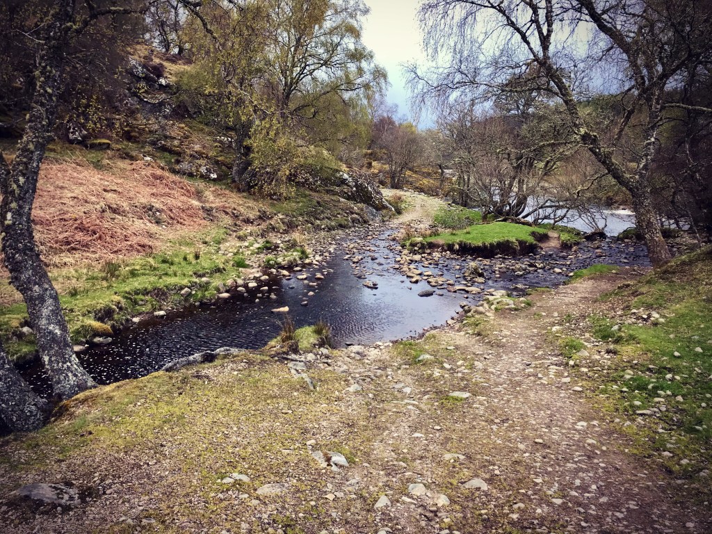
The pull up the hillside path out from the Sputan Dubh with a heavy rucksack was a killer! However, this was the official route and so it had to be done. The trail in this section climbs steeply for about 200 yards before gradually levelling out and weaving its way in and out of the hills following the contours of the Allt Doe. After crossing the river by way of a newly built wooden footbridge, I continued following the trail as it headed further inland and away from the Loch Ness into open land. Presently, the path meets up with a small stream called the Aban Burn where I stopped to harvest water as my bottles were running low. The trail then runs parallel to the Burn as it heads towards Loch Tarff just a short distance away.
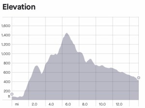
I have to admit that by this stage I was really beginning to see the difference in the terrain here on the South trail as opposed to the Great Glen Way. There were far less trees here and no forestry, yet the mountains all around certainly made up for it. From looking at the elevation for the South Loch Ness Trail it would appear that today (day 1) would have the highest ascents, after that, it didn’t appear as hilly.
It was here as I stood looking around though that it’s seclusion really hammered home. There was not a house nor property in sight anywhere and everywhere I looked was just tall forbidding mountains and open glens. Very much in stark contrast to the cosy, closed in scenes of the pine forests in which I had so recently been used to. I guess this can seem daunting, especially when considering the sheer size of the open landscape but I was thriving on it and couldn’t wait to start to climb through the hills to catch the real views.
Loch Tarff to Suidhe Chuimein (Cumin’s Seat)
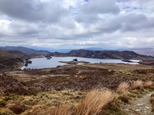
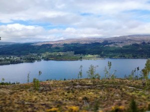
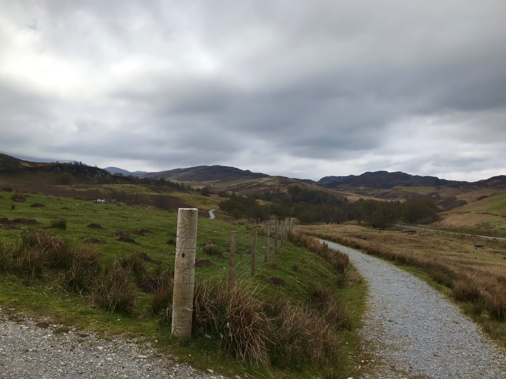
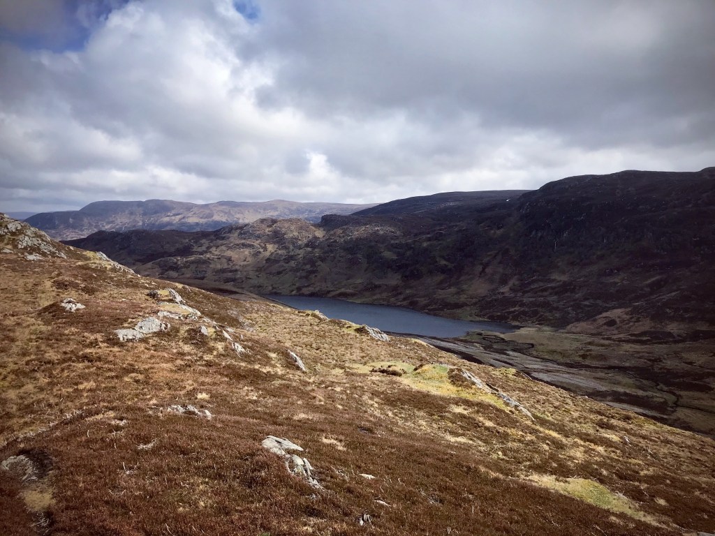
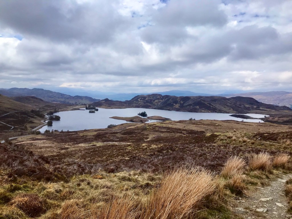
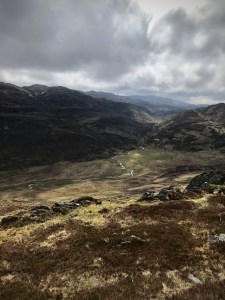
This was the stunning sight which greeted me as I ambled over the brow of the hill from the Aban Burn. I had known that Loch Tarff was fairly close by but I was not expecting it to be so beautiful. The entire meadow and surrounding mountains had completely opened up to reveal vast open space for literally miles. The trail proceeded to follow along the gorge in which the Loch Tarff lay and ran parallel to the water giving amazing viewing opportunities to anyone walking along it.
Loch Tarff had tiny islands dotted here and there and was surrounded by hills with larger mountains in the background. I had initially planned to take a rest stop here for lunch but after seeing what lay ahead, I decided to hold out just a while longer and climb the upcoming mountain to enjoy lunch with a view. The stretch of trail along Loch Tarff is very long and flat and seemed to take an eternity to reach the end but as I walked, I was gifted with amazing scenery. It was great to take in the sights from different angles as new valleys and glens opened up before me and there were always new surprises around every corner I came to.
The terrain here is rocky, uneven ground with barely any trees, lots of heather with long grasses giving the landscape it’s almost bare and barren appearance. Colours around Loch Tarff and the surrounding moorland are deep browns, rich red tones and green with cream blended in. The Spring colours were late coming this year due to the long and harsh wintery conditions which until only recently, had dominated this area and many others in the Scottish Highlands. Despite how vast and exposed this location was, it remains one of my favourite places observed during the Loch Ness 360 experience.
Upon reaching the end of this section along Loch Tarff, the trail meets up with the General Wade’s Military Road again and crosses over it to begin a steady but very steep climb up to the summit of the Suidhe Chuimein, a mountain with a viewpoint across much of the Highlands itself. It is here that the official start marker is placed for the South Loch Ness Trail. Despite beginning the trail back in Fort Augustus and following trail markers for a good 4 miles since then, it is only here that walkers get any real inclination that they are following a true documented hike trail.

Here is the first place that gives any real information about what to see and expect whilst on your travels and shows a large scale map of the areas passed though whilst venturing along the South side of the Loch Ness.
The climb up the Suidhe Chuimein from Loch Tarff was a long and tiring one. The added strain from carrying a full rucksack is what really made it hard work but as I climbed ever higher, I kept turning round and admiring the scenic panorama which took my breath away with every step. The pathway so far today had been a wide concrete, man made one which made the journey easier underfoot, however, now it became a rocky, uneven path in which extreme caution was required.
The summit of the Suidhe Chuimein was not marked by anything in particular which did surprise me (no cairn or trig point for me that day), it is literally nothing more than a bare mountain peak which involves a sharp scramble upon leaving the mountain path. Standing at approximately 1,400 feet above sea level, the views to be had from this vantage point however, took my breath away! I could see for literally miles in every direction and I have since learned that the Suidhe Chuimein (also named ‘Cumin’s Seat’), is the hot favourite spot to visit if hoping to view the whole of 7 lochans on a clear day.
The Trail of the 7 Lochs is another exciting trail hike spanning 50 miles in length (one definitely to consider in the future), however if weather conditions are good, the spectacular sight can be enjoyed from this vantage point high on the Suidhe Chuimein. The 7 lochans to look out for at this stage are as follows:
- Loch Mhor
- Loch Conagleann
- Loch Ruthven
- Loch a’ Choire
- Loch Duntelchaig
- Loch Bunachton
- Loch Geo Glais
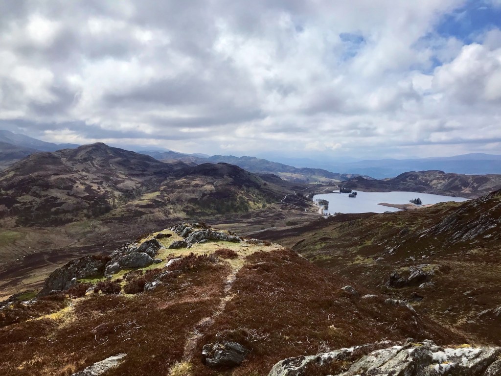

As I sat down to lunch in this idealistic spot on the mountain top, I remember how blessed I felt that day. I truly cannot have chosen a better time to have walked the South Loch Ness Trail than now with the weather being how it was. This section of the trail is vast and spans quite some distance. It’s remoteness and the fact that it is very open with no surrounding woodland or forestry would have made for a challenging and treacherous hike if I had been unfortunate enough to have had bad weather on my side. I could only thank my lucky stars that this was not the case that day.
Suidhe Chuimein to Whitebridge
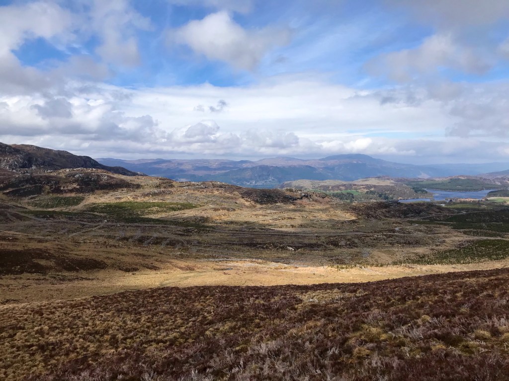
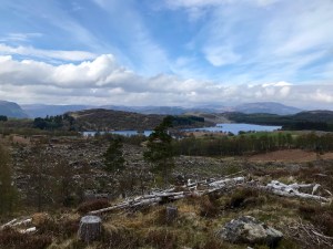
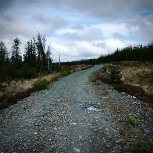
After a pleasant 30 minute lunch break on the edge of Suidhe Chuimein, it was time to head off and continue the journey. Edging back onto the trail, it was a steady descent along the rocky path down towards the wide asphalt road. As I walked I could see by the landscape that this area should have been the Whitebridge Plantation, an area of once lush forestry which was now no more. Every tree and greenery which had once grew here had been completely cleared in a vast project of deforestation. Although this had opened up the viewing opportunities somewhat and made the surrounding areas more visible, I couldn’t help but feel a little disappointed. Forestry and woodland areas are key to providing a viable habitat to the various wildlife which are popular in these parts of Scotland and without it, the population would most definitely suffer.
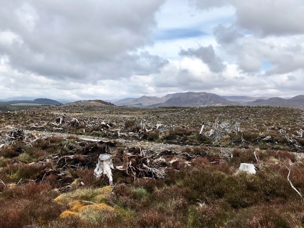
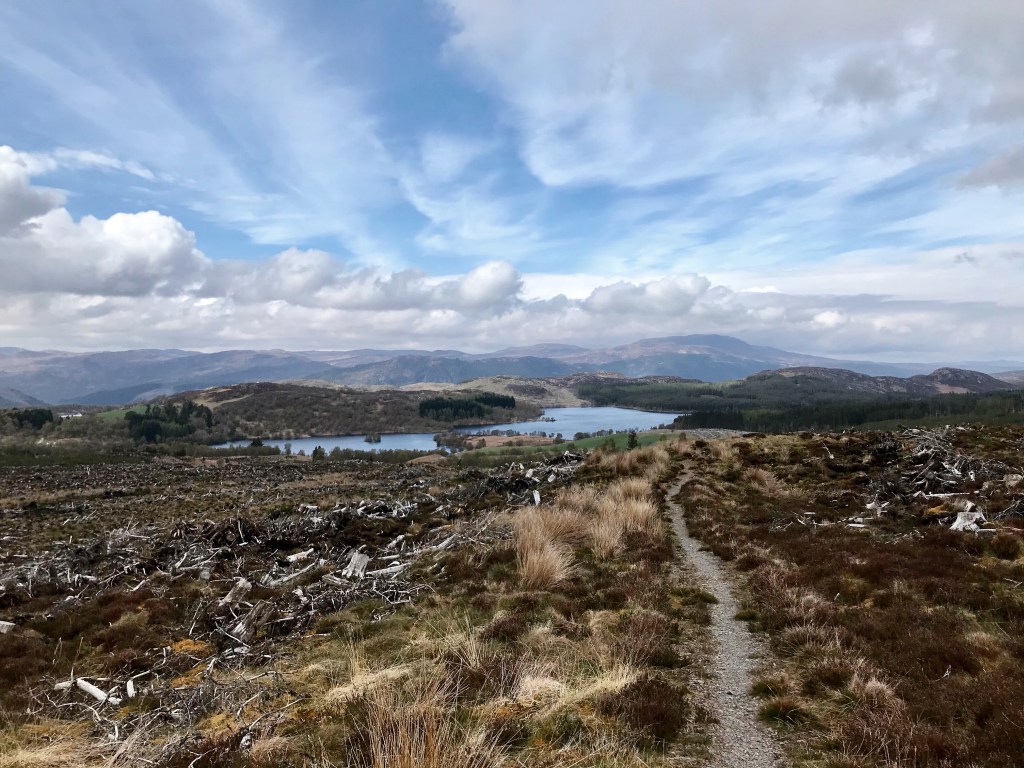
Deforestation in many circumstances is necessary for several reasons but it seemed that I had experienced an awful lot of it so far during this hike. This area at Whitebridge Plantation in particular was a large one and all that remained was vast amounts of dead, dry tree trunk and sticks. It certainly was not recent that this work had been carried out and no signs of any tree planting was visible. It really looked like a bad sign for much of the Scottish forestry in recent times and I remember praying that this would change if only to preserve nature and not completely spoil a very beautiful part of the Scottish Highlands. Check out the views though of the surrounding landscape.
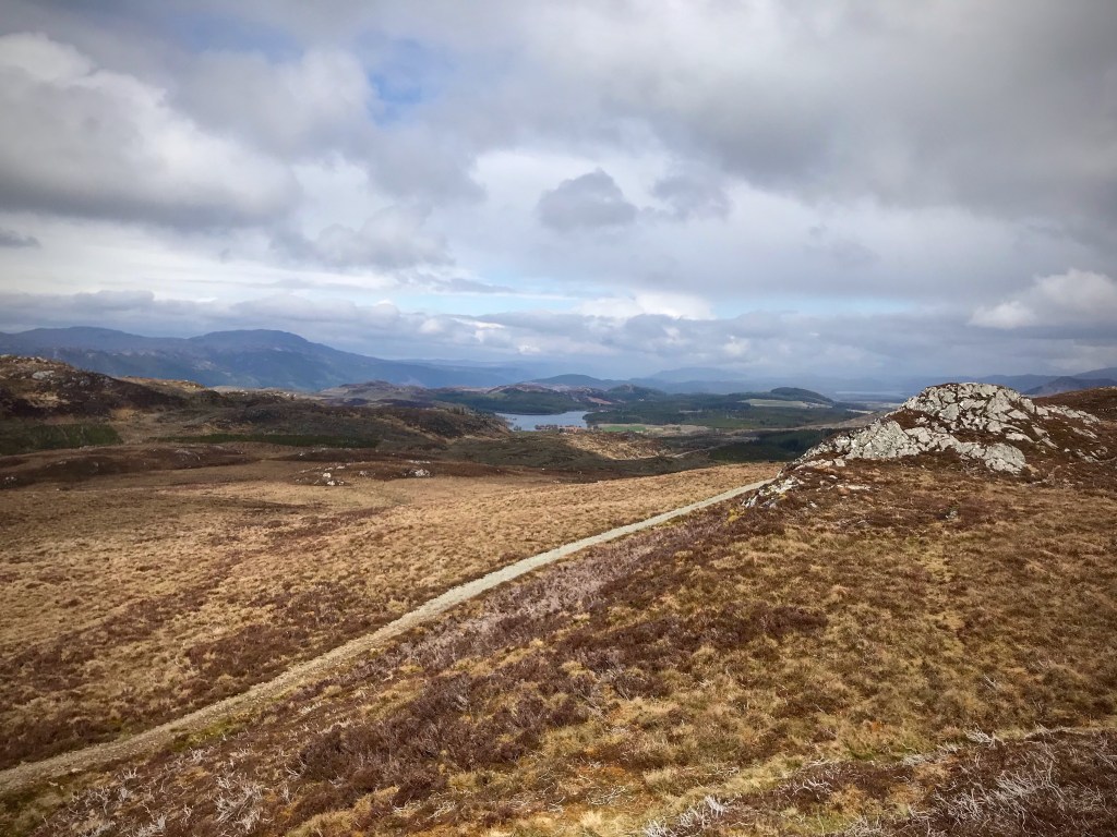
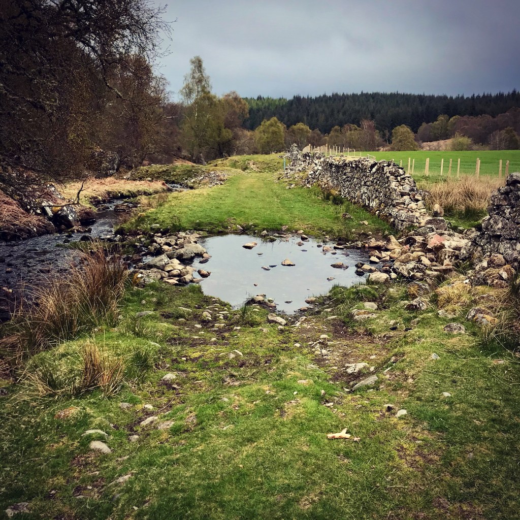
After following the dry asphalt road for a while, the trail eventually meets up with the Knockie Road, a long, single track lane with passing places which leads right the way to the General Wade’s Military Road. Crossing over to the opposite side, the trail continues off to the right through open fields towards the first of two large rivers, the Cumrack Burn and the Allt Breineag, the latter having to be crossed via a large wooden footbridge. Immediately upon crossing, the footpath turns sharp left and continues parallel to the river. Eventually I reached a place where the ground levels off towards the waters edge and there was a beautiful spot with short, soft grass. The perfect rest spot! I stayed here approximately 20 minutes while I heated some water for a coffee and relaxed taking in all my surroundings. What a beautiful day this was turning out to be. It was approximately 3pm and the sun was out shining in full force.
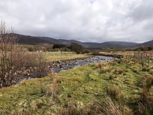
The river in this section was extremely shallow with large rocks breaking through the surface. This location would have made an ideal wild camping spot if only it had have been far enough. So far I had walked approximately 8 miles and didn’t feel this was anywhere near enough to consider calling it a day. Despite the initial hardship of the first stage of today’s hike, the rest had been downhill walking or reasonably flat. This makes a definite difference to how far a person can walk in a day and I felt I should make the most of my energy whilst the going was still good.
Upon leaving the Allt Breineag a short while later, the trail leads through a small clump of Silver Birch trees before hitting a grassy path through open fields just before the Ardochy Road. It was here that I spotted my first Deer of the day. I just caught sight of it for a fleeting moment as it ran at full pelt into the woodland and was gone within seconds. In the past I have always dreamt of seeing Deer. They are so rare in my locality that up until now, I had only ever seen one properly on this trail. During the first wave of the 2020 global pandemic of Covid 19, a Deer had stepped out of woodland opposite my house in urban Sheffield in June that year. It had been so random that I remember having to look twice to ensure I wasn’t hallucinating! I wasn’t, and after speaking with my neighbours shortly after, I learned that Deer do indeed roam the woodlands opposite my home and have for years. It just goes to show that we are never far away from these beautiful creatures even if we do not always see them.
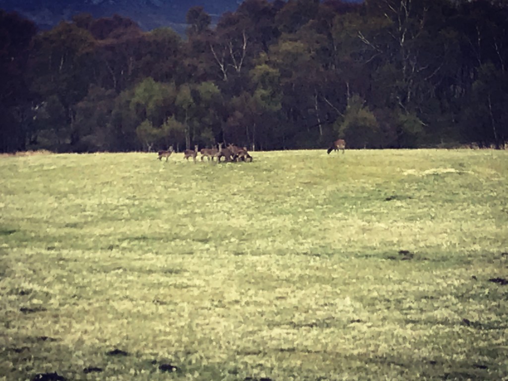
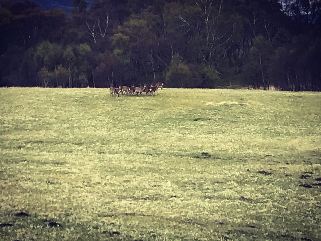
The next section of the trail along the Ardochy Road was probably my least favourite of the day. It was a very long and boring road which ran in a complete straight line, surrounded by high wire fences. On either side however were farmland and in a large field only a short distance away, my first opportunity arose to photograph and film a herd of Deer. I was in complete awe and thought at first that they must belong to the farm. They looked so at home in their surroundings despite watching me carefully as I photographed them. I soon figured though that they were in-fact wild Deer when they all suddenly leapt over a dry stone wall into the surrounding woods… but what a grand way to brighten an otherwise boring road walk! I was beginning to understand now how these trail hikes go. For every high there follows a challenging part, and every challenge is rewarded in beauty… You just have to open your eyes and look.
The long road continues as it heads into more civilised territory at the village of Whitebridge. I have to admit that by now, I was feeling grateful to see houses and people, the stretch of today being so long and secluded. After leaving the Sputan Dubh many hours earlier, I had only encountered one other person on this section of trail, a female hiker heading in the opposite direction as I had stood on the mountain top at Cumin’s Seat. I was fast learning that the Loch Ness South Trail was nowhere near as popular as I had initially thought and considering the time of year, definitely not utilised as much as the Great Glen Way.
The village itself consisted of farm buildings, rows of houses and pretty cottages in which some had real Pagan character. I walked past one particular property which stood out for me from all the rest, a detached house surrounded in fir trees which had a circular built wooden shelter in the garden. In the middle of the shelter was a burning fire with a Dutch Oven hanging over it and there were wicker decorations with firs, feathers and garlands. It was interesting to see and I was considering photographing it until I spotted a person sitting around the pot. As pretty as it was, I decided against it and hurried down the road.
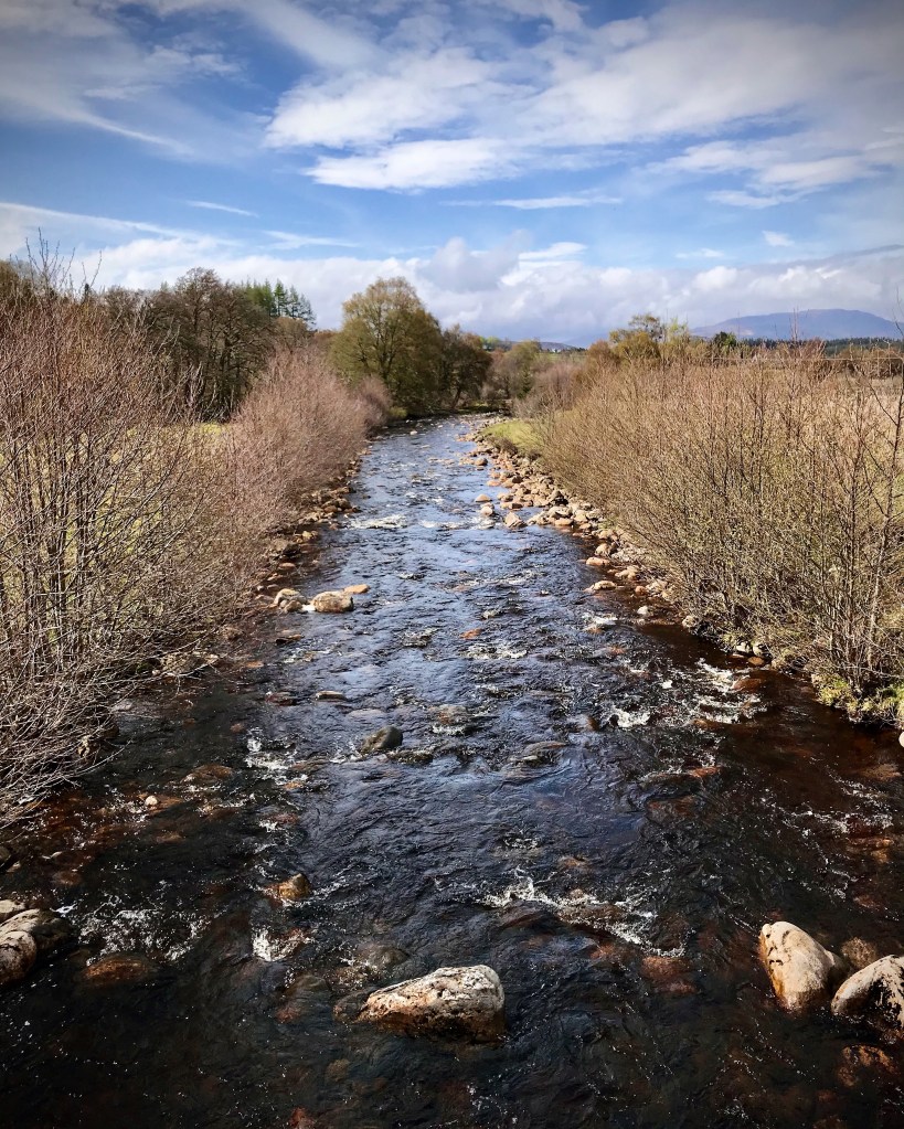
Further along, the trail eventually crosses a road bridge over the Cumrack Burn before heading off right through a small wooded copse of trees and joins up with the General Wade’s Military Road for the last time on this journey. The views over the bridge are quite breathtaking and in one part, the river looks almost perfect to swim in. What I would have given to take off my hot, sticky walking gear right there and then and taken a dip I really cannot describe! However, on closer inspection, I saw that the undercurrent was actually very fast despite the water looking relatively calm on the surface.
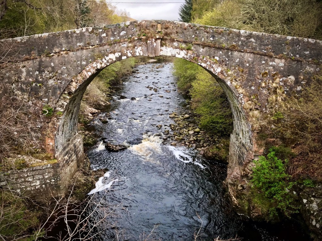
The next small section of trail involves following the road for approximately 15 minutes or so until a large public house can be spotted on the right. This is the popular Whitebridge Hotel which offers cooked meals and accommodation. If I’d had more time I may well have paid it a visit but it was getting late now and I still had not reached my camping destination. I did take a short 5 minute rest stop however to photograph the famous bridge crossing the River Fechlin which gave the village of Whitebridge its name.
Whitebridge to the outskirts of Foyers
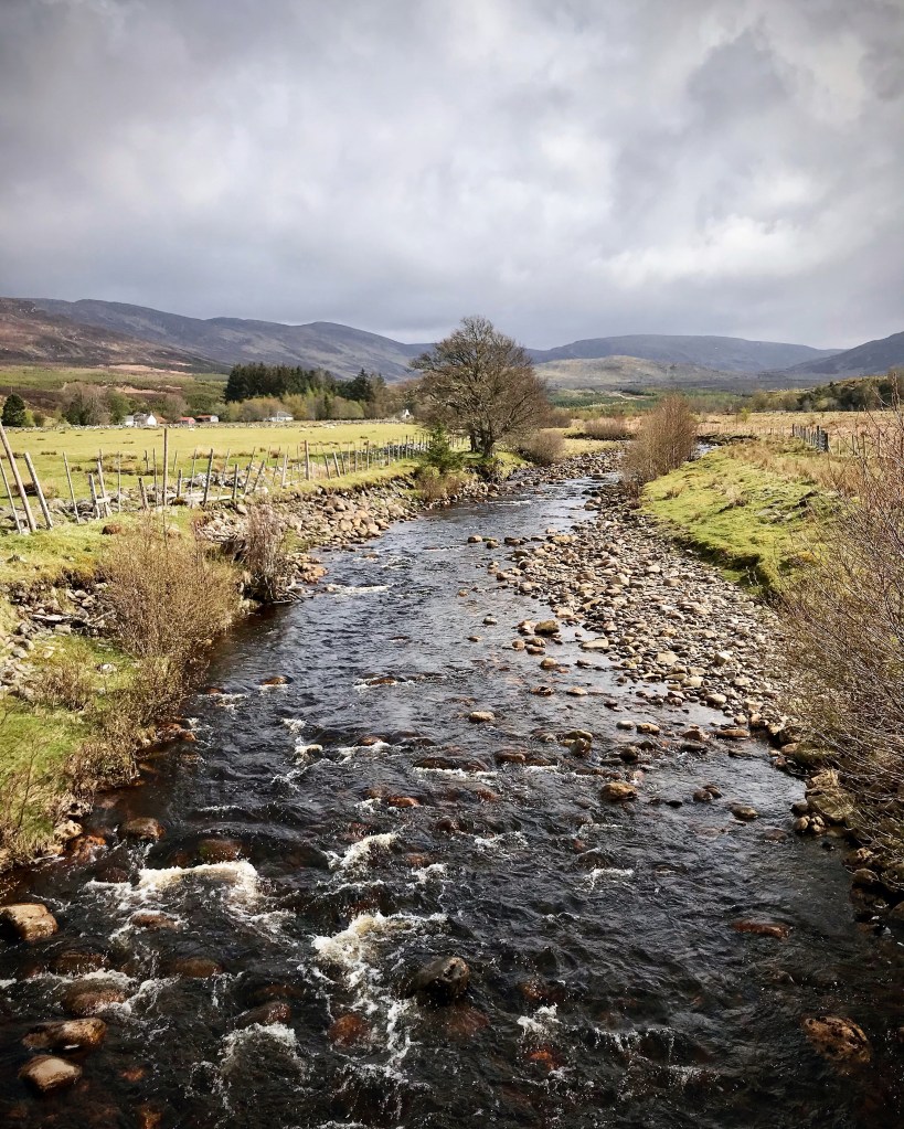
After leaving the bridge and heading back towards the hotel at Whitebridge, the trail crosses the General Wade’s Military Road and begins to head along a straight and narrow country lane running parallel to the River Fechlin which eventually joins an estuary becoming the River Foyers.
It was around this location that I noticed that I had no phone signal at all and my device was running completely on GPS only. I wasn’t sure how long this had been the case but I felt certain, due to my surroundings that it wouldn’t be returning any time soon. The village of Whitebridge is very secluded and closed in on all sides by the high mountains and hills which completely dominate the landscape in these parts. Although stunning in appearance, it is a very daunting thought as a solo explorer to know that evening is fast approaching and you have no phone signal. The feeling of being so alone becomes very real!
The lane in particular is a very long, tree surrounded lane which continues on for quite some distance. The only residents up these parts are situated in a tiny cluster of approximately 6 cottages which I passed as I headed onwards towards farmland. The lane eventually narrows down to become a farm track leading out across the fields towards a large working farm. As I walked, I could feel the air changing as the evening drew in and I began to feel the familiar chill of the Scottish nights. The light was starting to fade too and I hoped it wouldn’t be much further until I reached my camping spot.
The farm passed at this point is named Dell Farm. Upon reaching this point, the trail skirts around the back of the building where I had seen other vloggers state that there was an impressive honesty shack. This might have been available in pre Covid times but unfortunately it was no more. I remembered feeling a little deflated as I ambled past as I had been looking forward to purchasing some chocolate as a comfort during my lonely, no signal camp that night. Chocolate always made everything ok right? I guess tonight I was having to do without. As I left Dell Farm that evening, this would be the last civilisation I would see until the following day.
From this point on, the trail headed out through a metal farm gate into open pasture which had lots of limestone rocks dotted about and several paths leading off in various different directions. I had noticed also that I hadn’t seen a South Trail marker for several miles and this made this section of the route quite confusing. I was fortunate that I had plotted the 360 route into my Strava app beforehand and was able to use it to direct me otherwise I might easily have gone wrong. It was quite worrying to think that my app was only working without signal because I had set it running whilst in a location which had signal at the time. If I hadn’t done that, it would have been impossible to get directions.
After a time, the footpath narrows down further and heads inland to begin following the contours of a limestone crag which was very picturesque in the evening light. The tiny path winds between tumbled down dry stone walls which separate the crag and its surrounding woodland from the livestock fields on the right side.
During this section there are 3 stream crossings which are mentioned in the Loch Ness 360 Trail Guide. Two of the crossings are quite large with water that comes higher than walking boot height however, the level of water varies greatly on the time of year that the trail is walked. One thing I noticed was that other hikers had been generous enough to position large rocks of limestone as stepping stones to aid the crossing and due to this, I was able to cross safely without falling. When using the Loch Ness 360 Trail Guide to cycle the trail, it strongly suggests missing this section out completely as the ground is very rocky and uneven. There is an alternative route to the 360 for cyclists or hikers if considering doing the challenge in winter or when the water levels are deemed to be impassable.
It was along this section just shortly after leaving the last river crossing that I spotted a herd of 6 Deer running across the path in front of me. This meeting was probably my most favourite one of all and I believe it had an almost spiritual feel to it. The Deer all ran off up a path on my left which led up towards the crag top. As I approached the bottom of the path, I stopped and looked up in that direction fully expecting the Deer to have scarpered. How wrong was I? Standing at the top just a short distance from me was the same 6 Deer, all stood side by side in a line staring down at me. I froze and looked up at the tallest one of all. For a fleeting moment he/she stared right into my eyes. It was so powerful it felt that they could see right into my soul! Then another broke the silence with that all too familiar warning screech…. They all turned at once and was gone into the night…
Camping spot
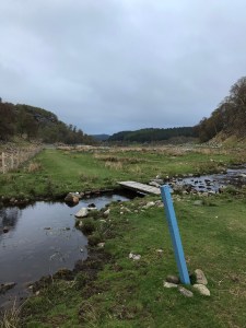
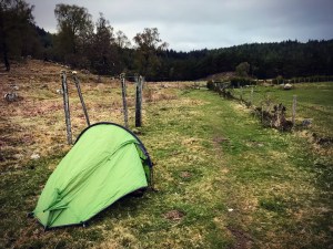
I finally discovered my camping spot at 7.45pm as I followed the limestone footpath along the crag bottom that evening. I spotted it by chance, a nice flat area of short grass just off the edge of the trail. The area I finished off the day in was slightly outside of Whitebridge but not quite quite as far as Foyers which, according to my GPS was only 2 miles away. Looking around, I figured that this spot was probably my safest bet. Despite being right on the trail itself, I felt confident that no one would be walking past at this time. The daylight was quickly fading and this location didn’t strike me as hugely popular with late night walkers. It was very secluded and out of the way with plenty of other suitable locations to walk the dog or go for an evening stroll. I set to work almost immediately putting up my tent and getting sorted for the night.
The location for night 4 of the Loch Ness 360 Trail hike was different in regards to what I had been used to whilst camping the Great Glen Way. On the opposite side of the Loch Ness and whilst following the Great Glen, my wild camping spots had been amongst the trees in dense forestry with lots of shelter from the elements. This location in the South Trail was very open with no protection whatsoever. I have to say that I definitely felt it as I put up the tent. The wind really carried across the open pasture and the temperature difference due to this was noticeable with it being the coldest night I had yet experienced on the trail. In saying that though, the spot was comfortable and was large enough for maybe three small tents. Due to having plenty of water in my bottles and reservoir bags, I didn’t need to rely on a water source that evening but there was the stream crossings just a short walk back down the path should I have fell short. After setting up, I managed to capture a photograph of the camping location just before the night finally closed in.
After getting settled and resting a little in the tent, it was time to prepare tea and get ready for bed. I believe I made the right choice in calling it a day here as I was well and truly shattered by this stage. According to my GPS I had hiked 15 miles today with the most challenging parts being almost at the start. Tea tonight consisted of a Tagliatelle Carbonara freeze dried meal by Expedition Foods, a small chocolate bar and a hot chocolate. Settling down to sleep, it took me a while to get warm that night. The wind really blew hard making the tent shake and just that was enough to keep me awake much longer than I anticipated. Checking my phone, there was still no signal in these parts so I was unable to give anybody an update on social media being restricted only to a single telephone call to my loved ones to reassure them that I was ok. Switching out the light and plunging myself into darkness, I laid peacefully listening to my surroundings. The last thing I remember was hearing the Deer close by in the woodland outside the tent. That familiar warning screech again… Then there was blackness.
Walk Summary
Distance: 15.11 miles.
Elevation gain: 1,884 foot.
To summarise today’s hike I thoroughly enjoyed it in more ways than one. A definite blessing was the weather! When considering the definite difference in terrain and landscaping, I was truly thankful that there was no rain as there had been just a day previously. Day 3 from Glenmoriston to Fort Augustus had seen drizzle from the second I awoke which progressed to torrential rainfall shortly after leaving Invermoriston. Despite being in relative shelter amongst the Fir trees in the forest, I had found myself completely drenched by the time I had reached Morag’s Lodge some 4 hours later. The reality of how lucky I had been with weather today really hit home when I thought about how exposed today’s section of the South Trail had been. If I had experienced yesterday’s rain and blizzard out on the Suidhe Chuimein for example, it definitely would have made for a totally different experience indeed!
Walking today’s section was a real treat when it came to mountain scenery and waterfalls. The Great Glen Way is beautiful in its own way especially when venturing through the forests and woodland, but having open spaces to really soak in the views are limited to snapshots whenever a gap was visible in the trees. Here on the south side there were much less trees to block the sights and so pretty much everywhere I looked today was very exposed. Whilst walking the section over Cumin’s Seat through to Whitebridge the sense of being completely alone really became apparent. There was no phone signal at all for pretty much most of the way and I only saw one person the whole time on the trail. I did however feel safe as I walked apart from one time near the Whitebridge Hotel which I will discuss further in the safety section of the epilogue blog post set for future release. Despite being long stretches where there were not properties or businesses, I did see plenty enough where I could have sought help if the situation arose.
I most definitely felt tired after my day of hiking and I was glad to be settled at my camping spot that evening. I have to say that I found it pleasantly strange to be camping out in the open once again, the comfort of the forest not an option on this night. Before my trip, I had thought a lot about how I might cope camping in the forest with all the strange sounds around me. It was something which up until now, I had never contemplated before and had spent my overnight wild camps in locations such as Kinder Scout in the Peak District. However after two successful camps in forestry whilst hiking the Great Glen Way, I had managed to overcome my fears. Tonight though, those fears of being exposed came at me like a thunderbolt. It was looking like my overall views on wild camping locations were changing rapidly and I would need to embrace it. It just goes to demonstrate how change can alter a person’s perception of a situation in a matter of moments.
I wholeheartedly Thank each and every person who has taken the time to read my Loch Ness 360 series blog and support me through this journey. Juggling work and writing in the current situation has been particularly hard these last few months and I apologise for how long it has taken me to edit and publish this fourth post. I am now hopefully back on schedule. Once again Thankyou for all your words of enquiry, support and interest. It means a lot to know that the blogs may have helped in some way and assisted in the planning and preparation of a thru hike. I am not an expert in backpacking and I have made some hilarious and at times, cringe worthy mistakes along the way, but I can say that a lot of my knowledge has come from making these mistakes, adapting a new coping strategy and learning from them as well as following other adventure bloggers both on WordPress and YouTube. Adventuring for me is a gift which I intend to make the most out of. I am truly grateful that I can share my experiences however dazzling or dismaying it might be and put into words a true account of what walking the trail was really like. I hope you enjoy part 4.
References and sources of information used in this blog are as follows:
- Britain Express. Fort Augustus, Loch Ness. http://www.britainexpress.com
- Cherry Island, Loch Ness. http://www.wander.am
- Loch Ness 360 Trail Guide. 2019. http://www.lochness360.com
- Wade bridge at Whitebridge. The South Loch Ness Heritage Group. http://www.southlochnessheritage.co.uk
All photographs used in this blog post are my own. They have been edited using Instagram editor tool and sourced from my Instagram account found at soloexplorer23. All photographs were taken using iPhone 7 camera. Images containing distance and elevation information was sourced from my Strava account and is actual data of the hike in question.
