6th July 2019.
Overview
I had been itching for an outing in the days leading up to this walk and had been browsing the internet looking for a great new location. I had decided I wanted something with a view that wasn’t too far to walk, something that would enthral me and make exploring the Peak District worthwhile on this hot Summers day in July 2019. On the day in particular, I again had my 1 year old daughter in a baby sling and my 16 year old Son accompanying me so the walk needed to be short and sweet, yet packed with excitement and adventure. As I sat trawling through endless photos on the internet, totally spoiled for choice over the wonderful places there on offer, my eyes fell on one image in particular. One that showed a rocky outcrop overlooking Ladybower Reservoir with stunning rock formations along the top.., and with that, my mind was instantly made up. I needed to go here! The area I had taken an interest to was Bamford Edge, which is an overhang of gritstone rock high up over the north of Bamford in Hope Valley. This part of Derbyshire, I had only passed through briefly and so Bamford was new to me from a walking and exploring point of view.
Bamford
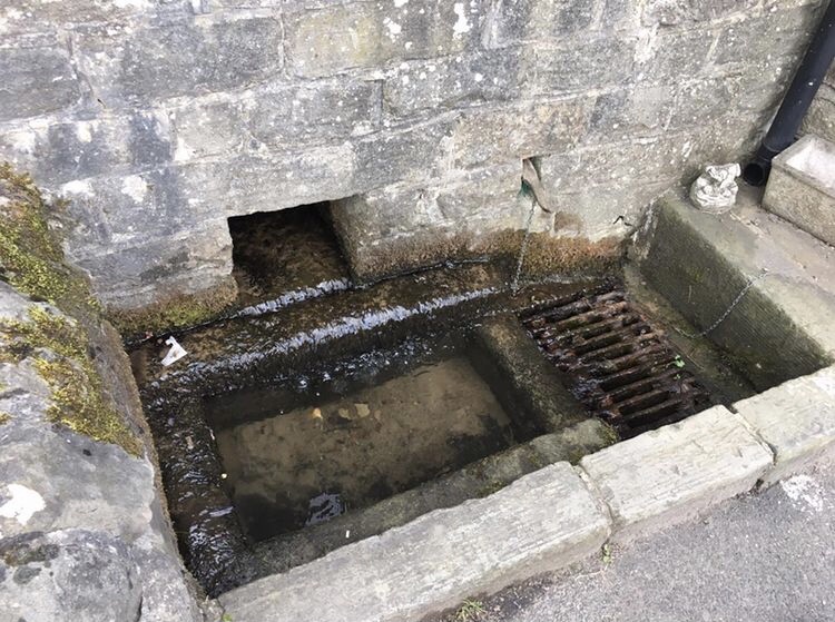
Bamford is a quaint and picturesque village within the Peak District, Derbyshire and is within close proximity to Hathersage, Hope and Castleton. The Ladybower Reservoir, which forms a chain of reservoirs with Derwent and nearby Howden is on the very outskirts of the village. Within the village itself are a few local, small shops, a few churches, a train station and four public houses, the Derwent Hotel which is now a self catering venue, the Anglers Rest, the Ladybower Inn and the Yorkshire Bridge Inn. The graveyard within the village contains graves which were moved many years ago after the flooding of the Derwent and Ashopton villages whilst constructing the Ladybower Reservoir. The remaining structures of the submerged villages can sometimes be seen sticking up through the water on Ladybower during the hot Summer months when the water levels drop considerably. The village is also well known for its yearly carnival and Well dressing display. The Well, although no longer functional, can still be seen on the right hand side of the Ashopton Road when heading through Bamford towards the Yorkshire Bridge Inn.
As we got off the train at Bamford Station at approximately 12.00, we headed up the Ashopton Road in the direction of the Edge which we could see high up the distance. I remember feeling a flurry of excitement at this stage thinking about what it would be like when we finally reached the top. Would it really look just like I’d seen in the photograph online? Or would I find like a lot of things I’d experienced lately, that it was nothing spectacular, just a clever photographer’s way of making us see things through rose tinted glasses?
The village of Bamford can be accessed by a number of ways. People can drive in their car and park in the village or free car park up on New Road which is much closer to the Edge, or people can use either the train or the bus. The bus services currently are the 271 and 272 which link Sheffield and Castleton calling at various places in Hope Valley along the way, and the Snake X57. The latter has currently been stopped due to the current Covid 19 pandemic but this service when running links Sheffield with Manchester and uses the Snake Road. An excellent service for people who wish to explore the moorland and scenery around the Snake Pass. Then there are train services regularly stopping at Bamford Station, so a wide variety of public transport options available.
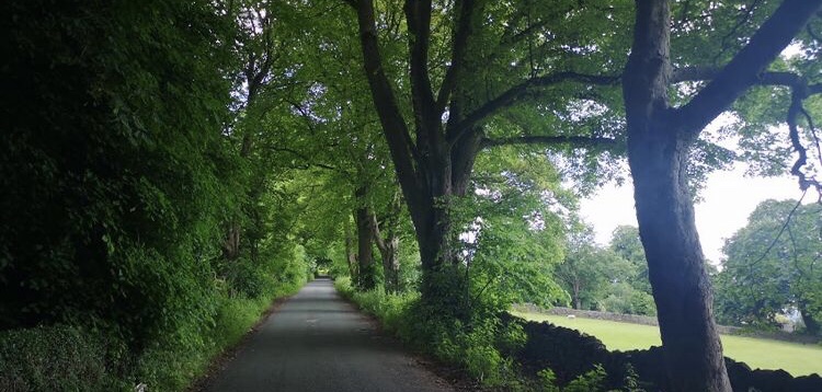
Before setting out on our walk, we decided to have lunch in the Anglers Rest and seen as it was a lovely sunny afternoon, we opted to sit outside in their beer garden. As we ate, we got chatting to a lovely waitress who served our food. She told us a little about the pub and we discovered that it was previously owned by the pub chain Admiral Taverns and was once at risk of being closed permanently. In October 2013, it was purchased by over 300 community residents and is now a community run pub which also serves as a cafe and post office. Upon finishing our meal, we decided to begin our walk up to the Edge and set off along the Ashopton Road. The way to get up to the Edge is by turning off on the right up a narrow road named New Road which is a considerable distance long. The walk up there is quite pretty with some beautiful views of the surrounding area as we climbed higher over Bamford. The road although relatively quiet on this day, requires people to stay alert at all times for cars and other modes of transport, as several times we had to swiftly step aside to avoid being knocked over!
The Edge
Upon approaching the part of the road where it levels out, there is a footpath on the left hand side of the road which leads up on to Bamford Edge. We began walking along this, me getting extremely tired due to carrying the extra weight of my daughter on my chest. I remember thinking to myself there and then that it would be ace when she eventually started walking and was strong enough to climb for herself. Then I stopped myself as I realised I was unknowingly wishing her life away. How awful! These times like right now are priceless and one thing is definitely for certain… You don’t get these moments back.
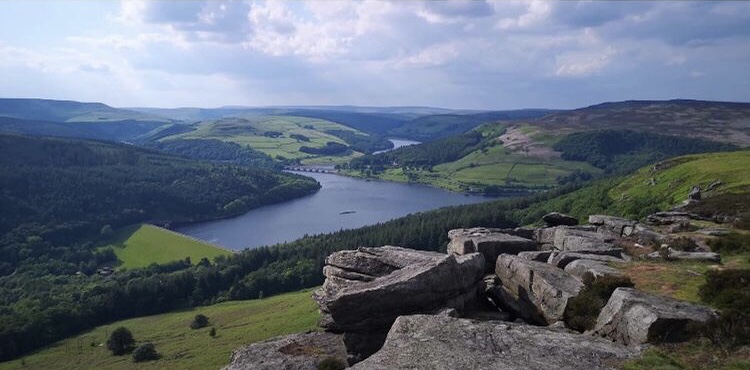
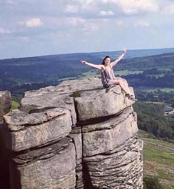
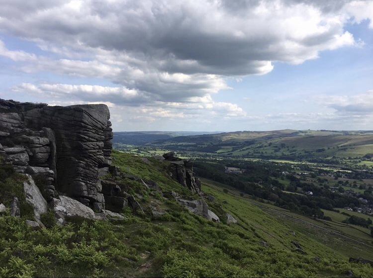
As we slowly walked along the Edge I knew we had made the right decision coming here. The views from the top are spectacular and I could see many other parts of the Peak District that I had never visited before. There was the whole of Bamford and right down into Hope Valley, Winn Hill, Ladybower Reservoir and the dam down at Heatherdene side. All around that area were thick dense forestry which I knew I needed to explore at a later date. Then over to the right was what I thought was the start of the Derwent Edge. My Son Luke was thoroughly enjoying himself this day and was climbing all over the large rocks and down the huge faults in the gritstone rock face. I did have to warn him several times to be careful and not fall over the edge as it was a sheer drop down in places. Although, if I’m honest, I’m a bit of a dare devil too and I had a couple of photographs taken sat on the edge of some high parts.

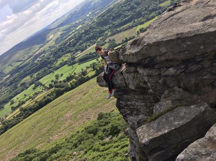
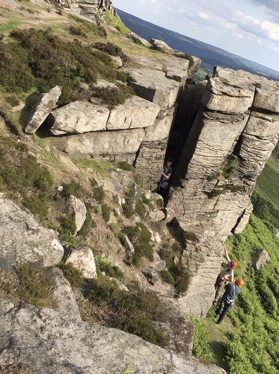
The terrain here is wild grasses, bracken and heather with slightly sandy paths along the Edge. Once up properly and walking along, it is a very pleasant and easy going path. It’s getting up there that takes time and effort! Care needs to be taken especially if straying from the path to walk closer to the edge as this involves climbing from rock to rock, and although the rocks are not a great height from the path, it is a pretty steep drop down the other side to the foot of Bamford Edge.
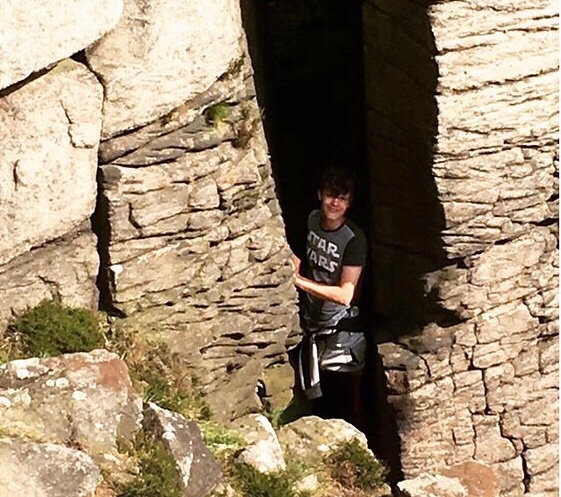
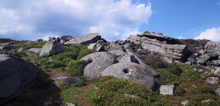
As we approached the end of the rock face, we sat down a while and admired the views. A million thoughts swam around in my mind of just what had gone on in the area over the years. What had Bamford Edge been used for in the past? Had anything sinister ever happened here? These are all questions I have found myself asking whenever I visit a new place and have been both pleasantly surprised and shocked by what I discover. It turns out that this Edge was used dating back to the Bronze Age in which gritstone was quarried in order to make millstones for the local mills in the area. Many were never finished or were abandoned having been too heavy to carry. Many millstones can still be seen dotted around in this location and in many others all over the Peak District.


Return to Bamford
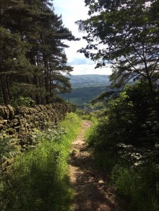
For the return back to Bamford from Bamford Edge, we headed back to New Road. The intention had been to go back the way we had came, but on the opposite side of the road and slightly to the right of a farm gate, I spotted a footpath leading down the hillside. I guess it was a risk but I decided to venture down it hoping it might lead us to the village and make the trek a little shorter. It was a rocky path and quite steep in places. I dreaded to think what it might be like to walk up it instead of down. The path opened up further down to become a dirt track named Leeside Road, although it looked anything but a road to me. In saying that it was quite a pleasant downward stroll alongside a dry stone wall and woodland and eventually, to my delight, led us straight to the Ashopton Road and the Anglers Rest.
Walk Summary
I thoroughly enjoyed this walk up onto Bamford Edge. It was definitely the right choice to make whilst having a baby in a sling as it is not too far of a walk from Bamford village. The weather conditions on this day made it all the more pleasant as I should imagine the Edge being quite windy on certain days and being very cold in the winter months. Bamford Edge is not a long edge and so the walk along it does not take too long. If people are just wanting a short walk with stunning views and scenery, this is definitely a good spot. It is easily accessible too and can be approached via various paths which lead up to it from different parts of Bamford. I would like to visit this location again when I haven’t got my daughter with me to spend a little more time exploring and to hopefully catch the sunset on a clear night. As much as I enjoy outings with her and introducing her to the Peak District, I feel restricted at times and limited to the type of exploring I can do. I have to bare her safety in mind and save the more daring episodes for another occasion. Overall, a brilliant walk for people who just want a short getaway with not too much climbing and also magnificent views from high places. Definitely a favourite for me.
Thank you for taking the time to read my personal blog about Bamford Edge. There is loads more history about the area which can be found on the internet easily enough. I sourced local information for this entry from peakdistrictwalks.net, Wikipedia and letsgopeakdistrict.co.uk.
All photographs for this entry were taken on iPhone 6 camera and edited by myself Lucy Bailey on 06/07/2019.

What a great adventure! You did choose wisely. That sure is interesting looking stone. The photo of he fault makes the stone look like it was ancient bricks. Good on ya for finding something off the beaten path!
LikeLiked by 1 person