12th May 2021.
It was another rainy awakening on what was to be day 3 of the 80 mile Loch Ness 360 hike. I had set my alarm for 5.30am that day in the hope to be ready and on the trail for 7am. It was set to be a long day to Fort Augustus from where I was camped on the outskirts of Glenmoriston and I wanted to get a head start with quite a few miles covered before lunch time. As I laid there now listening to the strum of rain hammering down on the outer fly sheet, it was hard not to think about the stunningly warm and beautiful evening I had enjoyed only the night before. It really had been something! I had sat for hours on the wooden bench at the side of my tent gazing out over the Loch, the warmth of the late afternoon sunshine beating down through the gap in the thick firs, and later, as the night closed in, a gentle breeze had rippled across the tree line taking the edge off the heat but keeping it warm none the less. Never then did I even give rain a second thought…. I had been spoiled these last 2 days considering it had forecast downpour for most of the week.
When I had first booked my travel and planned to hike the Loch Ness 360, I hadn’t considered that May is actually high rain season for these parts. Since learning this, I had made sure that everything in my rucksack was water tight and that my waterproof clothing was in a place of easy access. Due to the lack of phone signal in this location I had been unable to check the forecast for today which perhaps was a good thing. The beauty of not knowing is sometimes the key to remaining hopeful on these long distance treks, something I have since learned to appreciate.
Last nights camp had been a good one. After settling down in my sleeping bag I had relived the day by looking through the photos and videos I had taken during the walk. These included the ones I’d taken on day 1, in which the Abriachan Forest now seemed a million worlds away. It’s strange how long distance hiking does this to you. Only 2 days had gone by but due to the distance and how physically tiring it was, it seemed like I had walked for much longer.
Today did give me an extra reason to smile though. It was ‘clean sock’ day as I called it although, it wasn’t really just clean socks. Every 2 days all my clothes were changed and it was such a wonderful feeling. I had brought 2 changes of clothing for the whole hike and my first set had now been well and truly used. Slipping on my clean clothing now, I could smell the soap powder as clear as day which appeared all the more prominent due to the fact that my others were so sweaty and uncomfortable by this stage. I have to admit that I was looking forward to taking advantage of the laundry service and a hot shower at Morag’s Lodge this evening.

Breakfast today consisted of Granola with blueberries, another delicious freeze dried meal by Expedition Foods, and a Latte which I enjoyed despite preparing and eating within the tight confines of the Vango Nevis 100. My pitching location was ideal for a wild camp with flat, level terrain and short grass. Nearby was a water source with fresh, clean, trickling water which had served me well during the night. I honestly don’t think I could’ve found a more perfect spot anywhere else and I knew in my heart that I had made the right choice staying here. Although I had felt warm and comfortable over night, I certainly felt the chill this morning as I unzipped my sleeping bag. After 2 nights in the Nevis I was impressed. I hadn’t ever used the tent before and didn’t really know what to expect when I purchased it but I can say this.., it is well insulated and for a small one person tent it fits all your belongings inside quite comfortably. Once settled inside, it was a very cosy existence. It’s fair to say, I had no concerns so far about this tent.
As I was finishing getting ready in the tent, the rain, as if by some miracle suddenly stopped. I jumped at this chance to get everything packed away and into the dry bags as quickly as I possibly could. What a wonderful stroke of luck! Packing a wet tent away really was the least of my worries however, it was the thought of my sleeping bag getting damp which was the real problem. I can cope with most obstacles which are thrown my way but wet kit is not one I’m looking forward to. I hoped with every fibre of my being that I didn’t have to experience this any time soon. In no time I was sorted, packed away and ready to continue the trail at 7am.
Leave No Trace
So after packing up and securing all my rubbish in a carrier bag tucked in the top of my rucksack, I was ready to continue along the Great Glen Way. I took one last look back at my camping spot as I left that morning feeling a little sad that my time there was over. However, I knew that I would one day be back when I walk the actual Great Glen Way in the future.

Overview and day 3 walk route
The aim of today’s hike was to reach Morag’s Lodge in Fort Augustus where I had pre booked a room for the night. The reasoning behind this was so I could top up the charge in my power banks and wash my clothing. As mentioned in my earlier blogs, I had brought the bare minimum of clothing (just 2 days worth in fact) and I was looking forward to starting out again on day 4 fully rested, showered and with all clean clothing.
Today’s walk would take me high up into the forest around Glenmoriston and would continue along the Great Glen Way through Alltsigh towards the village of Invermoriston where I intended to stop for lunch. Along the route, there are 2 places where the path splits and an alternate route can be taken. The first one is just before Alltsigh where a choice of higher or lower route becomes available. Due to not walking the official Great Glen Way route on this occasion, I had chosen the lower route. This would take me through dense forestry where I would be gifted with the chance to visit Stone Cave and Stone Seat, two iconic landmarks along the Loch Ness 360 trail. The route then rejoins the main trail and drops down to Invermoriston. After passing through the village of Invermoriston, the Great Glen Way climbs up into the hills yet again towards the second choice of higher or lower route. Again I had opted for the lower route which continues through yet more forestry to Inver Coille and proceeds to follow the contours of Loch Ness all the way through Auchterawe and on into Fort Augustus. Today’s hike was set to be approximately 17 miles and an early start was definitely on the cards in order to make the check in early enough for evening meal at Morag’s Lodge.
Glenmoriston to Stone Cave
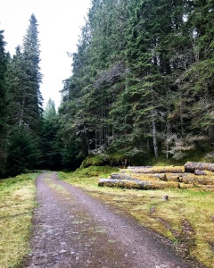
It was the gradual uphill climb along the forest path just shortly after 7am that morning that really brought me out of my shell and shook the final cobwebs of sleep from my eyes. Not a sound could be heard apart from the crunch of my boots on the gravelly track as i ambled along. Despite being wet from the recent rainfall, it was not cold, and the warmth of the morning on the trees and vegetation really brought out the smell of nature. This section of forest had a tremendous, rich aroma of strong pine, one of my favourite aspects of this hike and did wonders to add to the calming nature of this location. However, as I rounded a sharp bend in the steep path, two Deer who had been bedding down in the undergrowth slightly ahead of me suddenly leapt out, obviously startled by my appearance. I honestly don’t know who was more jumpy, me or them! They were gone in an instant leaving me no time once again to photograph them but it really was an amazing experience to see them if only for a short time. They were so close that I could make out the white markings on their back ends as they ran, all spotty and beautiful. I stood still in awe as they both leapt up a steep embankment and disappeared into the thick forest on my right.

Continuing on I passed by two tents pitched side by side in a comfortable spot at the side of the trail. All was still in the tents, their occupants no doubt still sleeping. It did cross my mind in that instant that it might just be the two male hikers that I kept meeting so far on the trail. I hoped it was as it meant that I may see them again perhaps later in Invermoriston. I remembered that they had mentioned whilst at the Eco Cafe that they were hoping to walk the high route on the Great Glen Way and I was looking forward to hearing about their adventure if I bumped into them again. I would keep my eyes open for them further along the trail.
Eventually, the path levelled out and became a much easier walk for quite some distance. The dense, thick pine trees gave way and the view over Loch Ness opened up giving spectacular views right the way along in front. It really was an amazing sight! The sheer stretch of the Loch and the low lying clouds running the length of it as far as I could see. The landscape surroundings were low level pine trees which resembled the appearance of Christmas trees. All around were the beginnings of Spring plants and vegetation which brought wonderful colours to the location and were tinged with a touch of autumnal colour with it. I had noticed that many flowers up in these parts were only just making an appearance now, which in May was considerably delayed in comparison to England where I had been seeing these for weeks. The temperature and weather difference was definitely more obvious up here and was a reason why some plants were late sprouting this year.


It was around this point that I came to a notice board indicating the first turn off for the alternative route along the Great Glen Way. As mentioned earlier, there are two sections where the trail forks and there is an option to take the high route along the mountain tops. The higher level routes do offer spectacular views over the Loch Ness and surrounding areas and on this section, if choosing that route, climbers get the pleasure of experiencing the ‘Troll Bridge’ and the ‘View Catcher’, two iconic and highly sought after gems of the Great Glen Way. Although I badly wanted to see them firsthand (I had only ever seen them on YouTube vlogs), after careful consideration I had opted to take the low route and miss out on the chance. The reason being that on this occasion, I was not actually doing the official Great Glen Way trail, I was hiking the Loch Ness 360 and felt obliged to stay as close to the Loch as possible. I made a pact to myself that I would return in the future to hike the Great Glen Way and then choose the high route to mix it up and add some change to the route. The high level paths are what really make the Great Glen Way, the View Catcher and Troll Bridge being the highlights. I felt that I would be spoiling the experience by not saving them for the official route. In saying that, the low level path had highlights of its own which included the Stone Cave and Stone Seat and meant hiking through more forestry yet again which I adored. With my decision made, I turned left at the fork and began heading down the windy path back into the forest.
High level route: 22km (13.5 miles)
Low level route: 23km (14 miles)

Just shortly beyond this point, I began hearing the familiar sound of text messages coming through on my mobile phone indicating that I was back in a signal area. I used this opportunity to message my family to let them know that I was ok and back on the trail. It was a worrying time for them as it was my first thru hike and they worried about me wild camping alone as a solo female backpacker. Having no phone signal at times was adding to that anguish. It was then that I learned that there had been a severe thunderstorm in South Yorkshire only the night before which was one of the worst in a long time. I was asked if I had experienced it yet. I reassured everyone that I hadn’t and that apart from rain overnight there had been nothing of that severity. However, I did receive the ‘Scarborough Warning’ off my teenagers that day who had said that my camping locations so far resembled something one would see in Friday the 13th, or better still, the Texas Chainsaw Massacre! They said that I should know better than to camp there! I guess that told me…
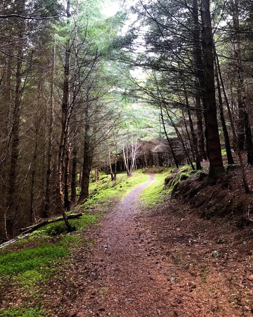
The following section was extremely long and eventually became an asphalt walkway once again. Although it isn’t particularly easy to walk on, the surrounding forest near Alltsigh was stunning. I crossed the Alltsigh Burn which had quite a severe drop down the side via a concrete, unfenced bridge. According to myth, it was here that the last ‘she wolf’ in Scotland was killed. The track continues uphill and on through the forest until a blue sign is spotted indicating Stone Cave on the right. At this point, the rain began falling again and I used this opportunity to don my waterproofs and protect my rucksack.


Stone Cave to Invermoriston
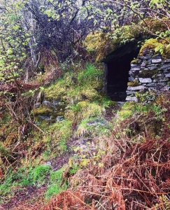
Stone Cave lies just to the right of the trail as you head in the direction of Invermoriston from Alltsigh and is so easy to spot that it cannot be missed. There is also a marker which clearly states it’s location just to the side of the trail. I have to admit that I was impressed with this find. The cave in itself is built slightly into the hillside but has been constructed mostly with stone in much the same way that a dry stone wall is built. Over the years, the exterior has become covered with mosses and wild plants of many types. The colours seen here are amazing. It reminded me of the kind of dwellings I saw in story books as a child and brought a million memories flooding back about my childhood. Due to the rain which was pouring down heavily, I decided to take a rest stop here and climbed up to the entrance of the cave. The interior of the cave has a long stone seating area which runs right around the edge. Although the roof is low, it is large enough to sit inside comfortably and made a wonderful shelter. The cave, it turns out was actually built many years ago for a local washer woman in the area, who used to walk this route every day to her place of work in the Invermoriston Arms. It marked the halfway point of her walk and proved to be a useful shelter for her especially when the weather conditions were particularly treacherous in Winter.
Continuing further along the Great Glen Way, the trail becomes a narrow path which begins a steep climb up the imposing hillside. At the top of this, the path joins the asphalt road once again where it heads alongside the forest towards Invermoriston. At this point, I saw a signpost which offered a detour to visit ‘Stone Seat’, another iconic feature of the lower route. I decided that I would walk the extra distance of the trail and pay it a visit as the sound of it intrigued me. Stone Seat is approximately a 10 minute hike from the trail and involves following a narrow forestry path for some distance before climbing steeply up onto the crags. Climbing up with the rucksack was tricky in places and due to the wet rocks, it was quite a slippery ascent. There is also a small section of scrambling over a large, steep rock but the views from the top are impressive. A Stone Seat has been constructed on the top of the high rocks with a view point over the tree tops towards the Loch near Invermoriston. It was still raining slightly and low mist was still present over the Loch when I was there but I was impressed still the same. I could only imagine the views on a clearer day.


The descent down from Stone Seat was a different matter. The path is very slippery and seemed more uneven going down than coming up. I took my time during this stage and finally made it down in one piece. The journey continued by rejoining the trail and following the asphalt track as it winds through the pines above the village of Invermoriston. As I walked along, it was impossible to see the village from so far up, but as the trees gave way to yet another vast area of deforestation, the views began to open up once again. Although I was following the low route of the Great Glen Way, it wasn’t exactly low. The trail was actually quite high up the mountain side and was not as close to the Loch as what you would expect. From this vantage point however, I could see right down the steep valley into the village and right the way across the River Moriston to the rolling hills of the second high route stretching away into the distance. Just before joining the steep, zigzag road down to the village, I spotted the path on my right which drops down from woodland where the first high route once again meets the main trail.

The drop down into Invermoriston is a knee shatterer! There is no denying that… I remember really feeling it as I walked on the road with my heavy rucksack and I found myself thinking about all the vloggers I had watched on YouTube who had hiked up this way in the opposite direction when hiking the official Great Glen Way. It must have been an absolute killer, especially if walking the high route as well. It really opened my eyes to just how challenging this section really is and hit home that this would one day be me in the future. The road is a single lane road with passing places and care needed to be taken when walking down. Despite it being this way, it didn’t stop motorists from using the road as a race track! I was pleased when I finally reached the bottom, crossed the main road and was safe at last on pavement heading towards a pretty cafe I had spotted on the corner in Invermoriston.
Invermoriston to Inver Coille
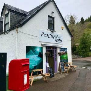
The time was now 12.30pm and I had walked approximately 10 miles by this point. I decided that lunch was definitely in order and I had spied the perfect place. Just on the corner of the main road leading into Invermoriston, there was a tiny cafe called PeachyNess which sells breakfast rolls, cakes, chocolate, coffee and sandwiches alongside many other treats and snacks. Since it had stopped raining, I opted to sit outside at the pretty tables set there and ordered myself a Latte and breakfast roll. I was becoming used to the way these meals were served now. The first time I visited Scotland, I remembered fondly being asked what I wanted and upon stating that I would like a breakfast roll, I listed the ingredients I would like with it. After that I was shocked when the waitress asked what I would like on the actual roll! Just bare in mind that you could end up getting much extra than you bargained for if you don’t state clearly that you want roll only with the ingredients on it!
Heading further into Invermoriston after lunch I passed by St Columba’s Well on my right. It meant having to glance over the wall running along the roadside although there are steps leading down to it should people wish to. The Well, also known as ‘Fuaran Choluim Chille’ in Gaelic was believed to have poisonous water which caused boils to the skin if touched. It was visited by Saint Columba’s who cleansed it of all impurities and evil spirits, and has apparently remained completely pure ever since. My impression of the Well was that it wasn’t much to look at in comparison to other Wells, but it is a sought after landmark and visiting spot when visiting the village.

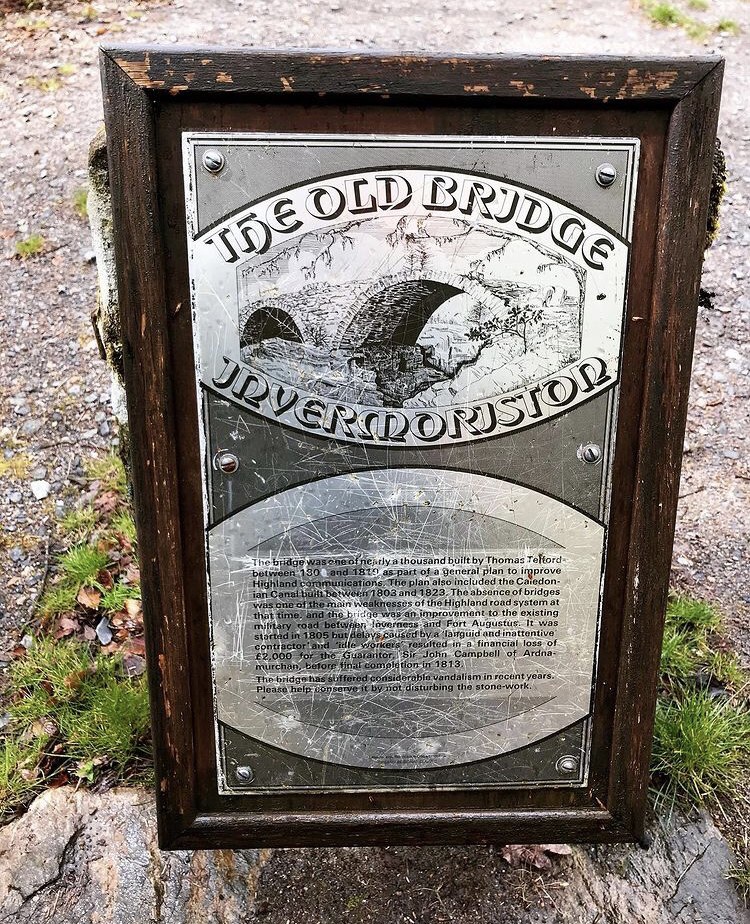
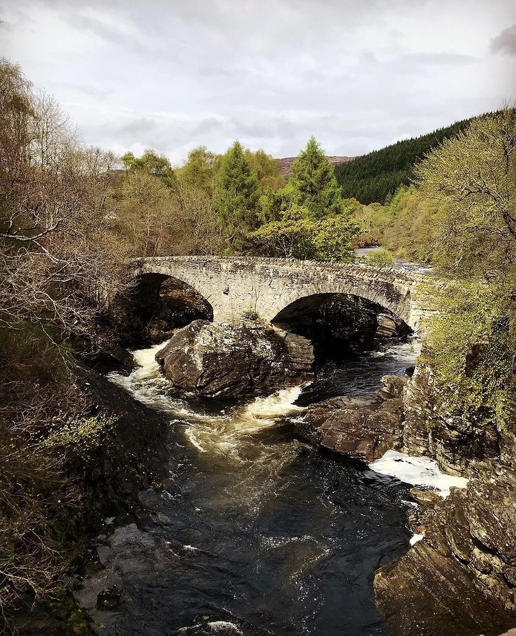
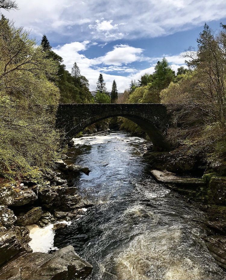
It wasn’t long before I heard the rushing waters of the River Moriston all around me as I headed further along the main road. Here was a very interesting spot and one of my favourite scenes throughout the Loch Ness 360 hike. Invermoriston is known widely for its beautiful waterfalls and white water rapid river which flows through it. The falls can be accessed in a number of ways and there are some stunning walk routes just in this location alone which give tremendous views of the river and its cascades. It is also home of the Thomas Telford Bridge, an old stone bridge which ceased use in the 1930s when the current bridge was built. The original bridge built in 1813 was at one point the only crossing over the River Moriston which linked Invermoriston with Drumnadrochit and Fort Augustus. It is still standing to this day and is the most photographed scene in Invermoriston. I spent a good 30 minutes here resting and admiring the sight around me, totally captured by its immense beauty. I remembered in an instant the way I had been drawn in and captivated by it in 2010 when I had last visited. It is truly a stunning spot and classed as one of the finest Northern Beauty’s that there is…


Leaving the village of Invermoriston, I turned off onto farmland track and the Dalcattaig road which continues for quite some distance before turning off on the left to begin a steady climb through open vegetation towards woodland. It was 7 miles to Fort Augustus from this location and it gave me a great feeling to know that I had a comfortable bed awaiting me later. The climb up the hillside towards the top road was a slow one due to the fact that I had really gone to town with lunch at PeachyNess. I could quite easily have curled up in a ball in the soft grass and slept… I was so stuffed! I was fast learning that having eyes bigger than my stomach was not such a great thing when out on the trail. Despite this, I pressed on eagerly and soon entered a pretty pathway that rose and fell as it climbed slowly up the hill. The ground was completely strewn with fallen pine cones here and it was lovely to see together with the views over the River Moriston back towards the hills near Stone Seat.
Just a short walk along the road at the top, I came to the place where the trail splits again for the high route along the Great Glen Way. Once again, I continued forward having chosen the low route and began dropping down to thick, dense forestry once more. This stretch of the hike is very long and involves around 2.5 miles of road walking. There was also a lot of road works and construction machinery here in which walkers were advised to stick to a designated walkway created by the construction team. There was a pathway behind fencing which was the only way through, however it did look as if some good work had already been done to make the route safer. Many pot holes and uneven surfaces had already been levelled and filled in. Although it is an eyesore at times to see this, it was comforting to know that the maintenance would be improving the route and that it would be only temporary. I can only thank the team for making these routes possible for us to enjoy in the way we do. One thing I noticed along this stretch though is that there is no opportunity to wild camp due to the trees growing so close together and the uneven ground in the forest. This is a long stretch so it is something to bare in mind when walking this trail. There is however a camp site at Inver Coille which is signposted from the roadside. On the occasion that I walked the Loch Ness 360, this was closed due to the restrictions of the recent Covid 19 pandemic.
Inver Coille to Fort Augustus
The route onwards through Inver Coille and beyond was a long asphalt road which appeared at times to be never ending. A continuous long stretch of thick forestry with the occasional waterfall which tumbled and fell down from the mountain in rushing cascades. The route ahead, although broken in parts by several wooden footbridges which crossed the walkway, was quite uneventful until the trees cleared. At this point, the long, straight road gifted it’s walkers once again with closer views of Loch Ness stretching right the way along to Fort Augustus, which still seemed a million miles away. I thoroughly enjoyed this section and found myself gazing across to the opposite side of the Loch which could be clearly seen in all its splendour. There appeared to be less forestry up the Northern side and far more open mountain terrain which was appealing. I found that tingle of excitement building up yet again as I thought about the adventure tomorrow which would see me begin the South Loch Ness Trail, the route used on the second half of the Loch Ness 360.
I was halfway across the open section of the trail when the heavens opened dramatically and the rain began to pour down in a torrential washout which lasted all afternoon. It was so sudden it took me by surprise. As can be seen in the previous photographs taken only minutes before, the sun had been shining and I had stood in the warmth having taken a short rest stop admiring the close up scenes of Loch Ness. Now it was hard to imagine as I hastily pulled on my waterproof clothing and pressed on. The route continued and followed the winding contours of the Loch before disappearing into yet more forestry at Auchterawe. It was a welcome sight and offered a little shelter from the heavy rain as I walked along. Passing the point where the higher route finally drops down to the main trail, I took a brief look up it at its steep climb towards the mountain top through an extremely narrow and dark, almost tunnel like footpath cutting through the forest. A part of me felt sad that I hadn’t experienced it this time around. It’s mysteriousness made me think about the calm before the storm. I had noticed there was a lot of that in these parts. For every hardship there was always an amazing reward which made the hike so worth it in my eyes. I just knew in my heart that many surprises would be waiting when I came back to walk the Great Glen Way in the future. Until next time…
The route from this point on continues through forestry and begins a decent which eventually ends in Fort Augustus at the main road leading into the town. Just before this section however, and just shortly after the high route rejoins the main trail, a blue notice board at the side of the track gives information about ‘Cherry Island’, an island on Loch Ness which in the 15th century, had once stood a castle. The island, (Eilean Muireach in Scottish Gaelic) is the only island on Loch Ness standing at 49 metres by 51 metres. It was far bigger in earlier years but became partly submerged when the Loch was raised to become part of the Caledonian Canal. I could just make out the island when looking closely through the fir trees which contains nothing now but small trees and shrubs. It was given its name Cherry Island because of the lush cherry trees which grew around the island back in its heyday.
Morag’s Lodge
Morag’s Lodge is a Youth Hostel situated in Fort Augustus just slightly up the Bunoich Brae if heading from the centre of town. After crossing a small wooden footbridge on the edge of woodland upon my approach, I began the final small accent of the day up the road towards the hostel. By now I have to admit I was absolutely shattered having walked 17 miles today and I was looking forward to a shower, dinner and comfortable bed. The time was 6.30pm as I reached the top of the hill and continued to follow the lane along the top. I didn’t spot the hostel straight away and was just beginning to wonder if I had walked past it, but then suddenly on my right, and set back from all the other properties, I noticed a large, white house set at the back of a vast patch of land with an impressive pond in the front. There was a large colourful sign which stated clearly ‘Morag’s Lodge’. I have to admit that I was pleasantly surprised as it didn’t look as I’d imagined. If it wasn’t for the information on the website, I wouldn’t have thought it was a Youth Hostel at all, but more of a bed and breakfast setting.
Inside was equally impressive. Upon entering, I approached the reception area and waited for check in. Sitting in this part of the house was a young lady who was very pleasant and made me feel welcome from the very beginning. She told me she had only just started working at Morag’s Lodge and was new to the area but was looking forward to exploring the highlands and seeing what it had to offer. My check in was completed by a lovely lady who informed me of how the house worked in regards to facilities and what was available. My room too was lovely and upon being shown to it, I decided to take advantage of the laundry facilities and order evening meal and breakfast for tomorrow. I have to admit that I was very impressed with the service here at Morag’s Lodge and would definitely recommend this accommodation to anyone.
Morag’s Lodge does have a website which gives useful information about the services and facilities they provide. It can be found at http://www.moragslodge.com. An example of services are: Breakfast, lunch and evening meal, laundry and drying facilities, on-site bar, lounge area and garden seating area, card payment and amazing power showers. Unfortunately due to ongoing Covid 19 restrictions, alcohol could not be consumed in the bar area at the time I visited being restricted only to the outside decking area or bedrooms. Shops in Scotland during this time also had alcohol restrictions in place with it only being served up until 8pm.
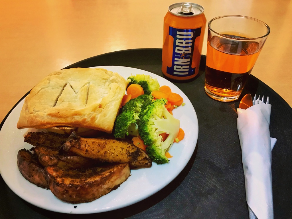
As I settled down to sleep that night I felt comfortable knowing that I was halfway along the Loch Ness 360. I had asked for all my clothing to be washed and dried, and they were all returned to me within 2 hours completely dry, folded up and smelling gorgeous. The power bank chargers that I had packed for this hike were able to be fully charged and I was overjoyed that each bed space had enough power sockets to accommodate this. The evening meal I ordered was meat pie with chunky chips and vegetables with Irn Bru which was absolutely delicious. I have to admit I loved every aspect of my stay at Morag’s Lodge. The setting is very hiker friendly with helpful and reliable staff who go out of their way to make their guests feel welcome. I had emailed the lodge several days beforehand, enquiring about the facilities and services I needed and these were all ready and available on my arrival. I cannot thank the staff enough, especially the young lady who served me and catered for my needs. After a long, tiring hike, it is this type of kindness which makes the journey memorable and will keep people returning for a long time to come.
Walk Summary
Distance walked: 16.47 miles.

Elevation gain: 1,883 feet.

I have to say that today’s hike from Glenmoriston to Fort Augustus was an eventful one to say the least, mainly due to the sporadic weather forecast which made conditions difficult and uncomfortable in parts. Weather definitely changes perceptions of an adventure and a particularly wet day does make the terrain more challenging. An example of this was when I reached the path that leads the way up to Stone Seat just before Invermoriston. The path looks tricky in parts anyway with the rocky sections that only have very tiny rocks to put your feet on during both the ascent and descent, however when wet, the rocks became extremely slippy indeed. This could be said for much of the walkway on the trail in these conditions. Places to shelter from the rain are few and far between with only the Stone Cave and cafe at Invermoriston being any kind of refuge. Waterproof outer clothing and sturdy walking boots were definitely maxed out today and with the torrential fall from around 3pm, I couldn’t have appreciated these more!
Tiredness also was a big issue having noticing that I didn’t seem to have as much energy as normal. I truly believe that the only thing keeping me me going was the knowledge that I was checked into a comfortable room at Morag’s Lodge, all the excitement and emotions of the last few days finally catching up. I had noticed too that as I approached the hostel, I had a throbbing headache which although rectified with the use of Paracetamol, still took a lot out of me during the hike. My shoulders at this stage were also hurting from carrying the rucksack through the long distances of the days.
In saying this though, the section of the Loch Ness walked today really was something in parts. The lower route, although being mostly forest track did have the added extras of the Stone Cave and Stone Seat which I found to be interesting landmarks bringing a sense of both history and character to the trail. It was nice to know that walkers of the lower route would still be rewarded despite not having the added benefits of a high vantage point. A part of me did feel I had lost out for not choosing the high road but I quickly justified this decision by remembering my reasoning, and knew in that instant that it gave me a wonderful opportunity to return later to do it all over again. Rome wasn’t built in a day the saying goes, and the same applies with hiking.
Fort Augustus is approximately 45 miles along the Loch Ness 360 trail so I was now past the halfway point by the time I reached Morag’s Lodge. For my first ever thru hike, I felt this was something of an achievement. It was here in Fort Augustus that the realisation dawned on me that shortly I would be leaving the Great Glen Way, my time on this fantastic trail almost over. Tomorrow would see me begin the first section of the South Loch Ness Trail which over the next 3 days would gradually bring me back to the safe confines of Inverness.
Writing and sharing my adventure means a great deal to me and to anyone who has read it so far, I can only thank you for your time and patience. The positive comments and posts on my social media pages, together with the feedback I receive from readers on my blog site are priceless and make all the difference to my adventures whether it was on this one or any others I embark on in the future. I don’t feel that this walk would’ve been as successful if it wasn’t for all of the help and support I have received.
I would like to offer special thanks to the numerous people who messaged me both on Instagram and personally on day 3 in particular, as this was the first day where phone signal was poor for long periods. Due to not having signal all night from day 2 until around 11am on day 3, it was a worrying time for some who noticed that I had not posted photographs or status updates in a while. Once again, I would like to thank Carl Johnson Outdoors for checking in. It made me feel safer knowing that people were looking out for me in spirit even if they couldn’t physically be there and gave me a wonderful sense of well-being in the hiker community knowing that fellow hikers and adventurers all look out for one another when we can. Carl would be setting out on his own adventure the following week to walk the West Highland Way in Scotland and I was looking forward to seeing his videos when released. This is the hike I have planned for 2022.
Once again, Thankyou for sticking it this far and I hope you enjoyed part 3 of my Loch Ness 360 Trail. Part 4 will see me leave the Great Glen Way for the more open mountain scenes of the South side of Loch Ness. Take care and see you soon.
All images for this blog post have been taken by myself Lucy Bailey using iPhone 7 camera device and edited from my Instagram page @soloexplorer23 using Instagram photo editor tool. Map image and elevation was taken from data tracked on my Strava app.
Resource sites used to aid this blog are as follows:
- Loch Ness 360 Trail Guide 2019 http://www.lochness360.com
- Day 80 Walking the black dog. Jules Forth. http://www.julesforth.com
- Invermoriston to Drumnadrochit Information – Great Glen Way. http://www.highland.gov.uk
- Great Glen Way 5 Low route: Invermoriston to Drumnadrochit. http://www.walkhighlands.co.uk

Hi Lucy =”,’= I must say you really captivated my interest. I felt I was right there beside you hurrying to put the water-proofs on as the heavens opened up. And sitting in the Cave, which I’ve seen before as it’s like the one on the Tissington Trail in the Derbyshire Dales. As for your headache, I suspect that was precipitated by the change in Barametric Pressure as you descended into Town that afternoon and of course the increase in free ions as the stormy weather approached. So, ya halfway through ya story, I canni wait for part 2. Thank you for sharing ya trekking tales.
LikeLiked by 1 person
Thankyou so much for your encouraging words Holly. It means a lot that you share the same interests and enjoy the blog. I’m starting part 5 soon. 🙂
LikeLike